File:KDEN AirportDiag!.png

本预览的尺寸:392 × 600像素。 其他分辨率:157 × 240像素 | 313 × 480像素 | 502 × 768像素 | 669 × 1,024像素 | 1,636 × 2,504像素。
原始文件 (1,636 × 2,504像素,文件大小:190 KB,MIME类型:image/png)
摘要
| 描述 |
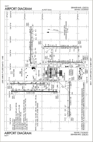
English: Source: Rotated copy of the original PDF from the National Aeronautical Charting Office in the FAA.
commons:category:Denver International Airport commons:category:Federal Aviation Administration commons:category:Maps |
| 日期 | 2007年6月17日 (原始上传日期) |
| 来源 | 本檔案是由Sreejithk2000使用CommonsHelper,從en.wikipedia轉移到維基共享資源。 |
| 作者 | 原上传者为英语维基百科的Inetpup |
许可协议

|
|
 |
原始上传日志
原始描述頁面位於這裡。下列使用者名稱均來自en.wikipedia。
- 2007-07-02 05:05 Incubusman27 2504×1636× (257176 bytes) {{PD-USGov-FAA}} same reason as previous version This image has been rotated 180 degrees from the previous version, so it is now right-side up.
- 2007-06-17 04:40 Inetpup 0×0× (205044 bytes) {{PD-USGov-FAA}} same reason as previous version
文件历史
点击某个日期/时间查看对应时刻的文件。
| 日期/时间 | 缩略图 | 大小 | 用户 | 备注 | |
|---|---|---|---|---|---|
| 当前 | 2021年2月22日 (一) 10:01 | | 1,636 × 2,504(190 KB) | SteinsplitterBot | Bot: Image rotated by 270° |
| 2011年9月18日 (日) 11:36 |  | 2,504 × 1,636(251 KB) | File Upload Bot (Magnus Manske) | {{BotMoveToCommons|en.wikipedia|year={{subst:CURRENTYEAR}}|month={{subst:CURRENTMONTHNAME}}|day={{subst:CURRENTDAY}}}} {{Information |Description={{en|Source: Rotated copy of the [http://naco.faa.gov/d-tpp/0710/09077AD.PDF original PDF] from the National |
文件用途
没有页面链接到本图像。
全域文件用途
以下其他wiki使用此文件:
- bn.wikipedia.org上的用途
- cs.wikipedia.org上的用途
- en.wikipedia.org上的用途
- es.wikipedia.org上的用途
- he.wikipedia.org上的用途
- simple.wikipedia.org上的用途
- th.wikipedia.org上的用途