File:Kingdom of Hungary counties.svg

此SVG文件的PNG预览的大小:779 × 513像素。 其他分辨率:320 × 211像素 | 640 × 421像素 | 1,024 × 674像素 | 1,280 × 843像素 | 2,560 × 1,686像素。
原始文件 (SVG文件,尺寸为779 × 513像素,文件大小:235 KB)
摘要
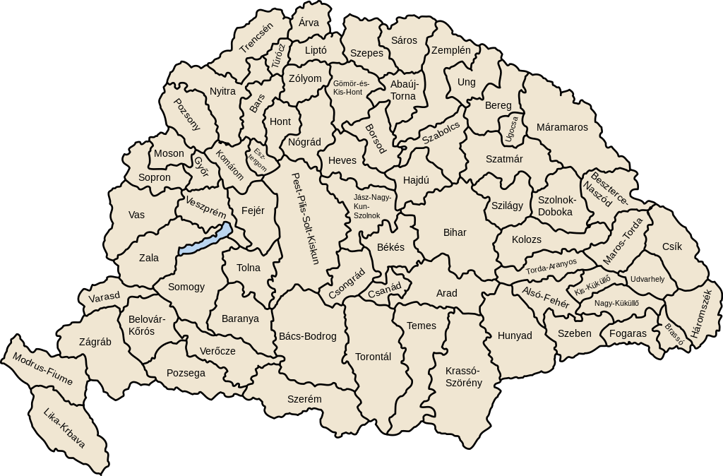
| 描述 | Map of counties of Kingdom of Hungary (Hungary proper and Croatia & Slavonia), 1886-1918 |
| 日期 | |
| 来源 | 自己的作品 |
| 作者 | User:IMeowbot |
| 其他版本 | 此文件衍生的作品: Kingdom of Hungary counties-2.svg |
| SVG development | W3C-validity not checked. |
许可协议
| 我,本作品著作权人,释出本作品至公有领域。这适用于全世界。 在一些国家这可能不合法;如果是这样的话,那么: 我无条件地授予任何人以任何目的使用本作品的权利,除非这些条件是法律规定所必需的。 |
文件历史
点击某个日期/时间查看对应时刻的文件。
| 日期/时间 | 缩略图 | 大小 | 用户 | 备注 | |
|---|---|---|---|---|---|
| 当前 | 2023年7月19日 (三) 07:41 | | 779 × 513(235 KB) | Alphathon | Reverted to version as of 22:47, 16 August 2022 (UTC). Bars/Hont and Csongrád/Bács-Bodrog borders are inaccurate, several more are distored (most only slightly) and the file is a "FakeSVG" – a raster image using an SVG as a container with no actual vector elements. |
| 2023年1月20日 (五) 22:43 |  | 8,277 × 5,472(589 KB) | Ascended Dreamer | Added FIume and increased line weight | |
| 2023年1月20日 (五) 22:31 |  | 8,277 × 5,472(607 KB) | Ascended Dreamer | Increased border accuracy | |
| 2022年8月16日 (二) 22:47 |  | 779 × 513(235 KB) | Alphathon | corrected õ → ő (tilde → double accute) | |
| 2009年12月5日 (六) 17:53 |  | 779 × 513(235 KB) | SimonTrew | Fix spelling error Veszprém. | |
| 2009年12月3日 (四) 14:24 |  | 779 × 513(235 KB) | SimonTrew | Fixed spelling of "Poszsony" -> "Pozsony". | |
| 2007年8月20日 (一) 20:25 |  | 779 × 513(235 KB) | Xavax | == Summary == {{Information| |Description= Map of counties of Hungary with Croatia & Slavonia, 1886-1918 |Source=own drawing |Date=April 30, 2006 |Author=User:IMeowbot |Permission= |other_versions= }} == Licensing == {{PD-self}} <!--Categories--> [[ | |
| 2006年4月30日 (日) 22:10 |  | 779 × 513(223 KB) | IMeowbot~commonswiki | line weight | |
| 2006年4月30日 (日) 21:34 |  | 779 × 513(221 KB) | IMeowbot~commonswiki | ||
| 2006年4月30日 (日) 18:34 |  | 779 × 513(195 KB) | IMeowbot~commonswiki | {{Information| |Description= Map of late 1870s Hungary counties |Source=own drawing |Date=April 30, 2006 |Author=User:IMeowbot |Permission= |other_versions= }} |
文件用途
以下页面使用本文件:
全域文件用途
以下其他wiki使用此文件:
- als.wikipedia.org上的用途
- an.wikipedia.org上的用途
- ar.wikipedia.org上的用途
- azb.wikipedia.org上的用途
- bg.wikipedia.org上的用途
- bn.wikipedia.org上的用途
- ca.wikipedia.org上的用途
- cs.wikipedia.org上的用途
- cy.wikipedia.org上的用途
- de.wikipedia.org上的用途
- el.wikipedia.org上的用途
- en.wikipedia.org上的用途
- Liptó County
- Zemplén County
- Hont County
- Bars County
- Turóc County
- Brassó County
- Bihar County
- Kingdom of Hungary
- Esztergom County
- Pozsony County
- Nyitra County
- Moson County
- Sopron County
- Bács-Bodrog County
- Heves County (former)
- Jász-Nagykun-Szolnok County (former)
- Trencsén County
- Zólyom County
- Pest-Pilis-Solt-Kiskun County
- Komárom County
- Bereg County
- Borsod County
- Ung County
- Hajdú County
- Máramaros County
- Szabolcs County
- Szatmár County
查看本文件的更多全域用途。