File:Kuala Lumpur locator map.svg

此SVG文件的PNG预览的大小:428 × 599像素。 其他分辨率:171 × 240像素 | 343 × 480像素 | 548 × 768像素 | 731 × 1,024像素 | 1,463 × 2,048像素 | 500 × 700像素。
原始文件 (SVG文件,尺寸为500 × 700像素,文件大小:306 KB)
摘要
| 描述 |
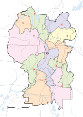
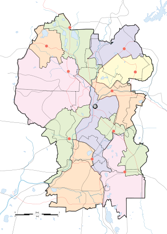
English: Map of w:Kuala Lumpur divided according to constituencies with highways (black) and major roads (red). City centre is marked by a Star Button and constituency towns marked by Red Buttons. Mukims (communes) are marked with dotted lines. |
||
| 日期 | |||
| 来源 |
Own work by uploader for w:Wikipedia:WikiProject Malaysia/Cartography New boundaries were from SPR Malaysia and Tindak Malaysia (2018) |
||
| 作者 |
|
||
| 其他版本 | File:Kuala Lumpur subdistrict locator map.svg |
许可协议
我,本作品著作权人,特此采用以下许可协议发表本作品:
本文件采用知识共享署名-相同方式共享 4.0 国际许可协议授权。
- 您可以自由地:
- 共享 – 复制、发行并传播本作品
- 修改 – 改编作品
- 惟须遵守下列条件:
- 署名 – 您必须对作品进行署名,提供授权条款的链接,并说明是否对原始内容进行了更改。您可以用任何合理的方式来署名,但不得以任何方式表明许可人认可您或您的使用。
- 相同方式共享 – 如果您再混合、转换或者基于本作品进行创作,您必须以与原先许可协议相同或相兼容的许可协议分发您贡献的作品。
文件历史
点击某个日期/时间查看对应时刻的文件。
| 日期/时间 | 缩略图 | 大小 | 用户 | 备注 | |
|---|---|---|---|---|---|
| 当前 | 2020年4月29日 (三) 19:50 | | 500 × 700(306 KB) | *angys* | add mukim boundaries |
| 2020年4月29日 (三) 19:18 |  | 500 × 700(293 KB) | *angys* | Refined boundary, many thanks to Tindak Malaysia | |
| 2018年9月10日 (一) 18:00 |  | 500 × 700(379 KB) | *angys* | new seat boundary from File:Selangor WPKL PRU14.svg | |
| 2009年6月22日 (一) 11:56 |  | 500 × 700(307 KB) | Mdzafri | {{Information |Description={{en|1=Map of w:Kuala Lumpur divided according to constituencies with highways (black) and major roads (red). City centre is marked by a Star Button and constituency towns marked by Red Buttons.}} |Source=Own work by uploade |
文件用途
以下37个页面使用本文件:
全域文件用途
以下其他wiki使用此文件:
- ar.wikipedia.org上的用途
- bjn.wikipedia.org上的用途
- ceb.wikipedia.org上的用途
- en.wikipedia.org上的用途
- Bangsar
- Taman Tun Dr Ismail
- RMAF Kuala Lumpur Air Base
- Wangsa Maju
- Islamic Arts Museum Malaysia
- User:Mdzafri
- Module:Location map/data/Malaysia Kuala Lumpur/doc
- Abdul Rahman Auf Mosque
- Kuala Lumpur Hospital
- Wikipedia:Meetup/Kuala Lumpur
- The Boulevard Hotel Kuala Lumpur
- Module:Location map/data/Malaysia Kuala Lumpur
- Wikipedia:Graphics Lab/Map workshop/Archive/Jun 2018
- 2019 Malaysia M3 League
- 2020 Malaysia M3 League
- Wikipedia:Graphics Lab/Map workshop/Archive/Feb 2020
- fa.wikipedia.org上的用途
- fr.wikipedia.org上的用途
- he.wikipedia.org上的用途
- id.wikipedia.org上的用途
- jv.wikipedia.org上的用途
- kn.wikipedia.org上的用途
- ms.wikipedia.org上的用途
- mt.wikipedia.org上的用途
- pl.wikipedia.org上的用途
查看本文件的更多全域用途。