File:Location of the Kingdom of Asturias.PNG
此为最大尺寸。
Location_of_the_Kingdom_of_Asturias.PNG (250 × 115像素,文件大小:5 KB,MIME类型:image/png)
| 我,本作品著作权人,释出本作品至公有领域。这适用于全世界。 在一些国家这可能不合法;如果是这样的话,那么: 我无条件地授予任何人以任何目的使用本作品的权利,除非这些条件是法律规定所必需的。 |
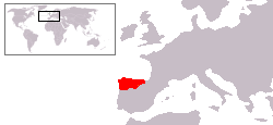
Mapa aproximado del Reino de Asturias en su apogeo.
Basado en Image:Location of the Kingdom of Scotland.PNG y Image:Península ibérica 814.svg
文件历史
点击某个日期/时间查看对应时刻的文件。
| 日期/时间 | 缩略图 | 大小 | 用户 | 备注 | |
|---|---|---|---|---|---|
| 当前 | 2009年6月19日 (五) 04:42 | | 250 × 115(5 KB) | AlGarcia | Correción. |
| 2009年2月1日 (日) 10:46 |  | 250 × 115(5 KB) | AlGarcia | ||
| 2006年7月27日 (四) 16:19 |  | 250 × 115(5 KB) | AlGarcia | {{PD-self/es}} Mapa aproximado del Reino de Asturias en su apogeo. Basado en Image:Location of the Kingdom of Scotland.PNG Category:Locator maps for former territories Category:Maps of the history of Spain Category:Asturias |
文件用途
以下2个页面使用本文件:
全域文件用途
以下其他wiki使用此文件:
- an.wikipedia.org上的用途
- ar.wikipedia.org上的用途
- arz.wikipedia.org上的用途
- ast.wikipedia.org上的用途
- be.wikipedia.org上的用途
- bg.wikipedia.org上的用途
- ca.wikipedia.org上的用途
- de.wikipedia.org上的用途
- eo.wikipedia.org上的用途
- et.wikipedia.org上的用途
- eu.wikipedia.org上的用途
- fa.wikipedia.org上的用途
- fr.wikipedia.org上的用途
- fy.wikipedia.org上的用途
- ga.wikipedia.org上的用途
- gl.wikipedia.org上的用途
- hr.wikipedia.org上的用途
- hy.wikipedia.org上的用途
- ia.wikipedia.org上的用途
- io.wikipedia.org上的用途
- la.wikipedia.org上的用途
- li.wikipedia.org上的用途
- lt.wikipedia.org上的用途
- nl.wikipedia.org上的用途
- no.wikipedia.org上的用途
- oc.wikipedia.org上的用途
- pnb.wikipedia.org上的用途
- ro.wikipedia.org上的用途
- sco.wikipedia.org上的用途
- sh.wikipedia.org上的用途
- tr.wikipedia.org上的用途
- ur.wikipedia.org上的用途
- www.wikidata.org上的用途