File:Lop Nur, Xinjiang, China.jpg

本预览的尺寸:588 × 600像素。 其他分辨率:235 × 240像素 | 470 × 480像素 | 753 × 768像素 | 1,004 × 1,024像素 | 2,366 × 2,414像素。
原始文件 (2,366 × 2,414像素,文件大小:372 KB,MIME类型:image/jpeg)
摘要
| 描述 |
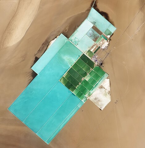
English: Natural-colour image of Lop Nur. The rectangular shapes in this image show the bright colours characteristic of solar evaporation ponds. Around the evaporation ponds are the earth tones typical of sandy desert. |
|||||
| 日期 | ||||||
| 来源 | NASA Earth Observatory | |||||
| 作者 | Jesse Allen and Robert Simmon | |||||
| 授权 (二次使用本文件) |
|

| 相机位置 | | 在以下服务上查看本图像和附近其他图像: OpenStreetMap |
|---|
Image captured by the Advanced Land Imager (ALI) on NASA’s Earth Observing-1 (EO-1) satellite. EO-1 ALI data provided courtesy of the NASA EO-1 team.
文件历史
点击某个日期/时间查看对应时刻的文件。
| 日期/时间 | 缩略图 | 大小 | 用户 | 备注 | |
|---|---|---|---|---|---|
| 当前 | 2011年6月20日 (一) 10:07 | | 2,366 × 2,414(372 KB) | Originalwana | {{Information |Description ={{en|1=Natural-colour image of Lop Nur. The rectangular shapes in this image show the bright colours characteristic of solar evaporation ponds. Around the evaporation ponds are the earth tones typical of sandy desert. }} |
文件用途
以下2个页面使用本文件:
全域文件用途
以下其他wiki使用此文件:
- ro.wikipedia.org上的用途
- sl.wikipedia.org上的用途
- te.wikipedia.org上的用途