File:Map Denmark CIA extended.gif
此为最大尺寸。
Map_Denmark_CIA_extended.gif (300 × 347像素,文件大小:16 KB,MIME类型:image/gif)
摘要
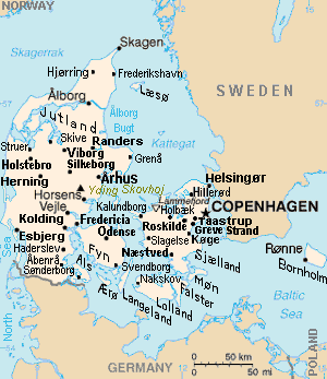
| 描述 | Map of Denmark, showing largest cities and island/region names. Most city names (31) have been labeled with font-face Arial or Arial Narrow, as font-size 8 or 10; the island/region names are labeled on the diagonal at a 20-degree slant. Denmark contains over 300 towns, but they are evenly dispersed around 35 main towns, except near Copenhagen, which has very high density. |
| 日期 | |
| 来源 | Derivative of CIA map (Wikimedia Commons): Image:Denmark-CIA WFB Map.png (adding 25 labels, restoring color to CIA hues, and magnified 15%) |
| 作者 | Wikid77 (derivative of CIA map, adding 25 labels) |
| 其他版本 |
This map has some variations:
|
许可协议
|
|
 |
Format

This file is purposely maintained in GIF format (most international GIF-related patents have expired) for compatibility with the original CIA maps. Semi-automatic conversions to PNG-format might lose the color hues of the CIA maps, tending to shift to lighter blue and shift beige to white. A larger, detailed version of the map is being expanded, with more of the smaller 300 towns added.
文件历史
点击某个日期/时间查看对应时刻的文件。
| 日期/时间 | 缩略图 | 大小 | 用户 | 备注 | |
|---|---|---|---|---|---|
| 当前 | 2012年11月30日 (五) 16:26 | | 300 × 347(16 KB) | Ras67 | cropped |
| 2007年9月4日 (二) 13:51 |  | 300 × 350(16 KB) | Wikid77 | relabeled "NORWAY"/"POLAND"; raised "Taastrup"/"Koge" near city-dots | |
| 2007年9月3日 (一) 15:41 |  | 300 × 350(16 KB) | Wikid77 | added "Kalundborg" by lowering "Fredericia"/"Odense"/"Fyn" and lowered Copenhagen star, "Taastrup"/"Koge" and "Greve Strand" etc. | |
| 2007年8月31日 (五) 13:24 |  | 300 × 350(16 KB) | Wikid77 | slashed 'o' 3x | |
| 2007年8月29日 (三) 06:04 |  | 300 × 350(16 KB) | Wikid77 | {{Information | Description=Map of Denmark, showing largest cities and island/region names. | Source=Derivative of CIA map | Date=29-August-2007 | Author= Wikid77 (derivative of CIA map) | Permission=(see below) }} |
文件用途
以下页面使用本文件:
全域文件用途
以下其他wiki使用此文件:
- ast.wikipedia.org上的用途
- ca.wikipedia.org上的用途
- es.wikipedia.org上的用途
- et.wikipedia.org上的用途
- fa.wikipedia.org上的用途
- gl.wikipedia.org上的用途
- hr.wikipedia.org上的用途
- ja.wikipedia.org上的用途
- kn.wikipedia.org上的用途
- ko.wikipedia.org上的用途
- mk.wikipedia.org上的用途
- ms.wikipedia.org上的用途
- pt.wikipedia.org上的用途
- th.wikipedia.org上的用途
- vi.wikipedia.org上的用途