File:Map of Virginia Counties and Independent Cities.svg

此SVG文件的PNG预览的大小:800 × 371像素。 其他分辨率:320 × 149像素 | 640 × 297像素 | 1,024 × 475像素 | 1,280 × 594像素 | 2,560 × 1,189像素 | 1,260 × 585像素。
原始文件 (SVG文件,尺寸为1,260 × 585像素,文件大小:220 KB)
| 描述 |
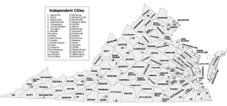
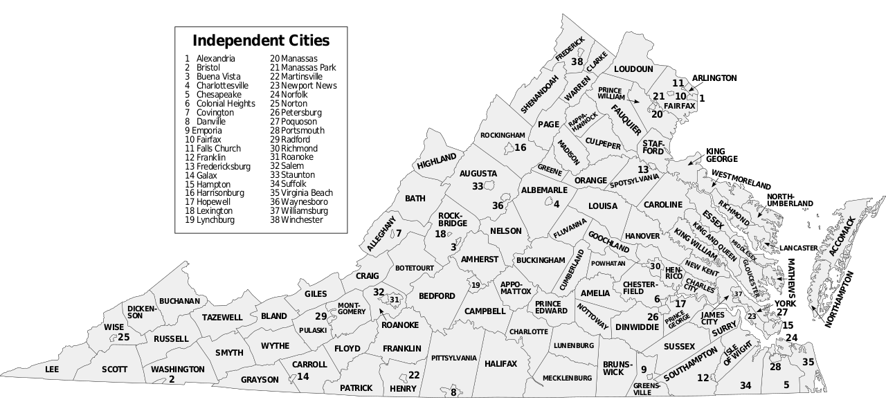
Map of Virginia counties and independent cities, SVG format. David Benbennick made the outline map modified here. For more information, see Commons:United States county locator maps. |
||
| 日期 | (UTC) | ||
| 来源 | |||
| 作者 | |||
| SVG开发 | 此SVG 文件使用了内嵌文本,可以使用任何文本编辑器轻松翻译。
|
本文件采用知识共享署名-相同方式共享 3.0 未本地化版本许可协议授权。
- 您可以自由地:
- 共享 – 复制、发行并传播本作品
- 修改 – 改编作品
- 惟须遵守下列条件:
- 署名 – 您必须对作品进行署名,提供授权条款的链接,并说明是否对原始内容进行了更改。您可以用任何合理的方式来署名,但不得以任何方式表明许可人认可您或您的使用。
- 相同方式共享 – 如果您再混合、转换或者基于本作品进行创作,您必须以与原先许可协议相同或相兼容的许可协议分发您贡献的作品。
原始上传日志
This image is a derivative work of the following images:
- Virginia counties and independent cities map.gif licensed with Cc-by-sa-3.0-migrated-with-disclaimers, GFDL-en
- 2006-10-16T20:34:33Z JosN 1009x491 (71702 Bytes) Map of Virginia counties and independant cities.
- Map of Virginia highlighting Floyd County.svg licensed with PD-self
- 2006-02-12T17:43:56Z David Benbennick 7486x3247 (228776 Bytes) {{subst:User:Dbenbenn/clm|county=Floyd County|state=Virginia|type=county}}
Uploaded with derivativeFX
文件历史
点击某个日期/时间查看对应时刻的文件。
| 日期/时间 | 缩略图 | 大小 | 用户 | 备注 | |
|---|---|---|---|---|---|
| 当前 | 2016年11月8日 (二) 21:08 | | 1,260 × 585(220 KB) | Offnfopt | removed left over boundary from defunct city removed in previous edit and centered Bedford text |
| 2016年11月8日 (二) 05:22 |  | 1,260 × 585(219 KB) | Offnfopt | Update per request @ W:WP:GL/MAP Bedford is no longer a city so removing from list | |
| 2009年9月15日 (二) 18:43 |  | 1,260 × 585(742 KB) | Soundoftoday | Fit to legal-size paper | |
| 2009年9月15日 (二) 18:36 |  | 7,488 × 3,249(741 KB) | Soundoftoday | {{Information |Description=Map of Virginia counties and independent cities. David Benbennick made the outline map modified here. For more information, see Commons:United States county locator maps. |Source=*[[:File:Virginia_countie |
文件用途
以下页面使用本文件:
全域文件用途
以下其他wiki使用此文件:
- bjn.wikipedia.org上的用途
- cy.wikipedia.org上的用途
- en.wikipedia.org上的用途
- fa.wikipedia.org上的用途
- fi.wikipedia.org上的用途
- frr.wikipedia.org上的用途
- hu.wikipedia.org上的用途
- id.wikipedia.org上的用途
- pt.wikipedia.org上的用途
- ro.wikipedia.org上的用途
- ru.wikipedia.org上的用途
- sq.wikipedia.org上的用途
- tr.wikipedia.org上的用途