File:Mauryan Empire Map-zh-classical.png
此为最大尺寸。
Mauryan_Empire_Map-zh-classical.png (400 × 337像素,文件大小:10 KB,MIME类型:image/png)

|
此historical map图片可使用矢量图形重新创建为SVG文件。这具有很多好处;更多信息请参见共享资源:待清理媒体。如果存在此图片的SVG格式,请将其上传,然后将此模板替换为
{{vector version available|新图片名称}}。
建议您将SVG命名为“Mauryan Empire Map-zh-classical.svg”,这样在使用Vector version available(或Vva)模板时就不需要填写新图片名称参数。 |

|
This map has been uploaded by Electionworld from en.wikipedia.org to enable the |
摘要
| 描述 |
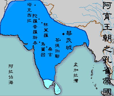
English: A political map of the Mauryan Empire, including notable cities, such as the capital Pataliputra, and site of the Buddha's enlightenment.
Original picture was uploaded here.
The Classical Chinese Modification is made by User:Itsmine. |
| 日期 | File was made on August 3, 2006, using Microsoft Paint. |
| 来源 | Based upon common poltical maps of the Mauryan Empire, created from this template: Image:Marathas.GIF |
| 作者 |
许可协议
| 本作品已被作者Vastu释出到公有领域。这适用于全世界。 在一些国家这可能不合法;如果是这样的话,那么: |
文件历史
点击某个日期/时间查看对应时刻的文件。
| 日期/时间 | 缩略图 | 大小 | 用户 | 备注 | |
|---|---|---|---|---|---|
| 当前 | 2007年5月12日 (六) 08:41 | | 400 × 337(10 KB) | Itsmine | {{ew|en|Vastu}} {{ShouldBeSVG|map}} ==Description== A poltical map of the Mauryan Empire, including notable cities, such as the capital Pataliputra, and site of the Buddha's enlightenment. Original picture was uploaded [[:Image:Mauryan Emp |