File:MetroLink map (article version).svg

此SVG文件的PNG预览的大小:800 × 167像素。 其他分辨率:320 × 67像素 | 640 × 133像素 | 1,024 × 213像素 | 1,280 × 266像素 | 2,560 × 533像素 | 1,936 × 403像素。
原始文件 (SVG文件,尺寸为1,936 × 403像素,文件大小:407 KB)
.svg?uselang=zh)
.svg?uselang=zh)
.svg?action=history&uselang=zh)
.svg)
摘要
| 描述 |
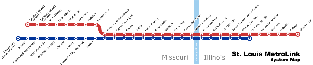
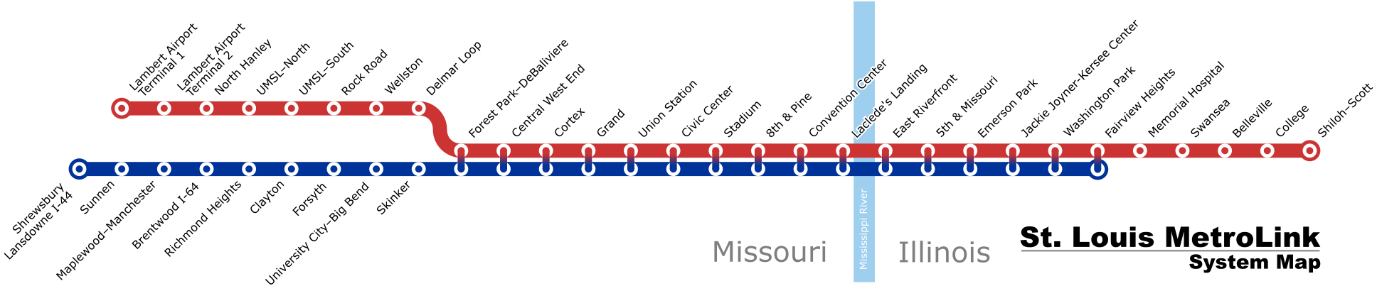
English: A schematic map of the the St. Louis MetroLink system as of August 2018 |
| 日期 | (latest version) |
| 来源 | 自己的作品 |
| 作者 | Millbrooky |
| 其他版本 |
 |
许可协议
我,本作品著作权人,特此采用以下许可协议发表本作品:
本文件采用知识共享署名-相同方式共享 3.0 未本地化版本许可协议授权。
- 您可以自由地:
- 共享 – 复制、发行并传播本作品
- 修改 – 改编作品
- 惟须遵守下列条件:
- 署名 – 您必须对作品进行署名,提供授权条款的链接,并说明是否对原始内容进行了更改。您可以用任何合理的方式来署名,但不得以任何方式表明许可人认可您或您的使用。
- 相同方式共享 – 如果您再混合、转换或者基于本作品进行创作,您必须以与原先许可协议相同或相兼容的许可协议分发您贡献的作品。
文件历史
点击某个日期/时间查看对应时刻的文件。
| 日期/时间 | 缩略图 | 大小 | 用户 | 备注 | |
|---|---|---|---|---|---|
| 当前 | 2019年4月2日 (二) 14:29 | 1,936 × 403(407 KB) | Dream out loud | extended Blue Line to Fairview Heights | |
| 2019年2月21日 (四) 12:23 | 1,936 × 403(392 KB) | Dream out loud | fixed station names, changed appearance of Red/Blue shared stations | ||
| 2018年8月11日 (六) 19:39 | 1,925 × 380(473 KB) | Pi.1415926535 | update for Cortex station opening | ||
| 2015年3月9日 (一) 23:57 | 1,920 × 460(390 KB) | Dream out loud | updated Laclede's Landing station name | ||
| 2015年2月1日 (日) 21:21 | 1,920 × 460(385 KB) | Dream out loud | |||
| 2008年10月31日 (五) 21:20 | 1,920 × 460(484 KB) | Millbrooky | one last revision to make text slightly larger | ||
| 2008年10月29日 (三) 17:57 | 1,885 × 400(492 KB) | Millbrooky | {{Information |Description= |Source= |Date= |Author= |Permission= |other_versions= }} | ||
| 2008年10月28日 (二) 15:53 | 1,885 × 400(72 KB) | Millbrooky | {{Information |Description={{en|1=A schematic map of the the St. Louis MetroLink system as of October 27, 2008.}} |Source=Own work by uploader |Author=Millbrooky |Date=2008 |Permission= |other_versions=MetroLink map.svg }} <!--{{Image |
文件用途
以下页面使用本文件:
全域文件用途
以下其他wiki使用此文件:
- cy.wikipedia.org上的用途
- de.wikipedia.org上的用途
- en.wikipedia.org上的用途
- fr.wikipedia.org上的用途
- he.wikivoyage.org上的用途
- ru.wikipedia.org上的用途
- uk.wikipedia.org上的用途
- www.wikidata.org上的用途
.svg)