File:Meyers b9 s0067b.jpg
本预览的尺寸:457 × 599像素。 其他分辨率:183 × 240像素 | 366 × 480像素 | 586 × 768像素 | 781 × 1,024像素 | 1,562 × 2,048像素。
原始文件 (1,562 × 2,048像素,文件大小:594 KB,MIME类型:image/jpeg)
摘要
| 描述 |
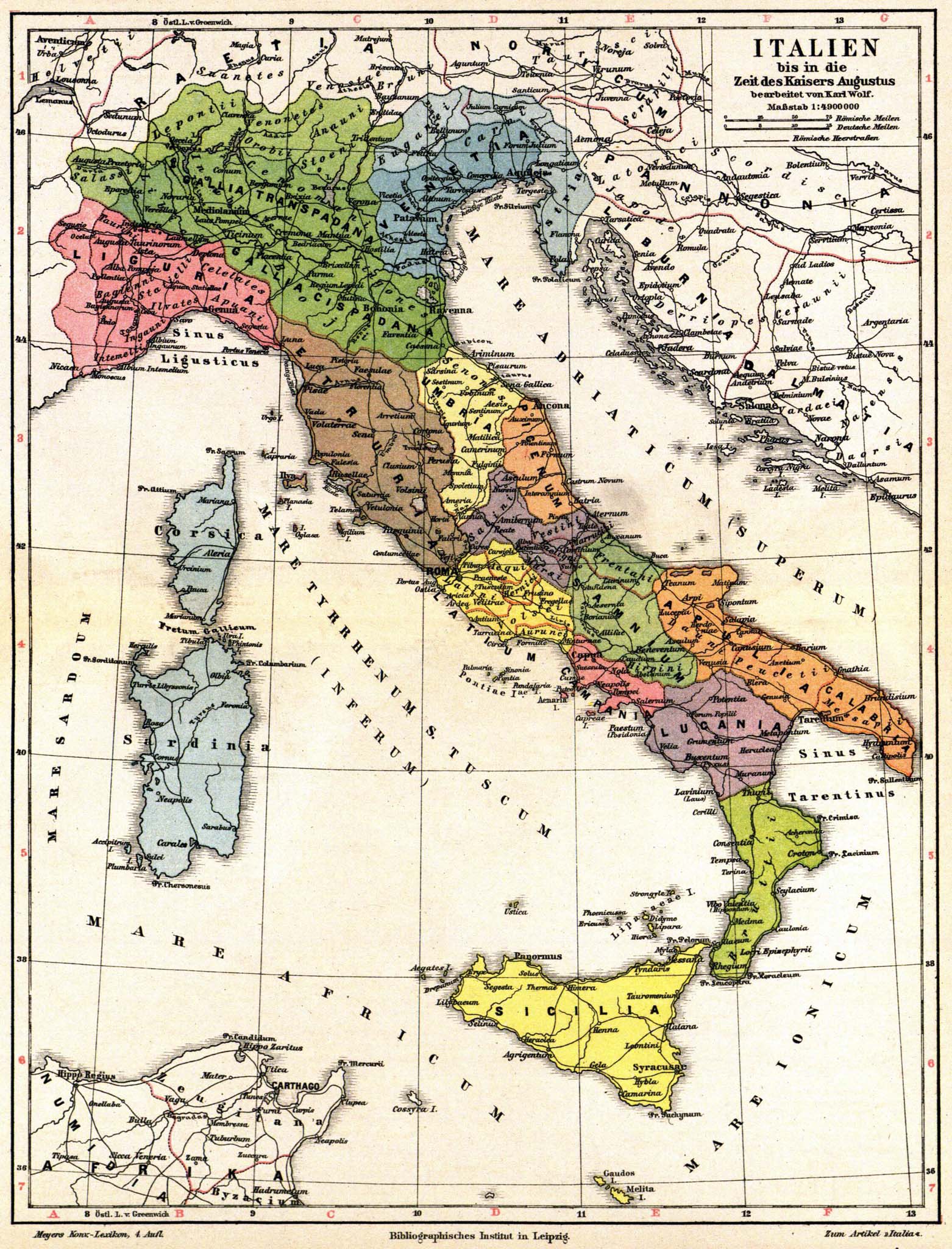
English: Old map of Italy and Austria, in time period of Caesar Augustus (27 BCE - AD 14). The map has labels in Latin & German, from Volume 9 of German encyclopedia Meyers Konversations-Lexikon.
Deutsch: Italien bis in die Zeit des Kaisers Augustus bearbeitet von Karl Wolf. Maßstab 1 : 4 900 000. |
| 日期 | 从1885年到1890年 |
| 来源 |
Meyers Konversations-Lexikon, Band 9 http://susi.e-technik.uni-ulm.de:8080/Meyers2/index/index.html |
| 作者 | Karl Wolf |
| 其他版本 |
Register:
|


许可协议
| This image comes from the 4th edition of Meyers Konversationslexikon (1885–90). The copyrights have expired and this image is in the public domain. |
|
本作品在其来源国以及其他著作权期限是作者逝世后100年或以下的国家和地区属于公有领域。 | |
| 本文件已被确认为免除已知的著作权法限制(包括所有相关权利)。 | |
文件历史
点击某个日期/时间查看对应时刻的文件。
| 日期/时间 | 缩略图 | 大小 | 用户 | 备注 | |
|---|---|---|---|---|---|
| 当前 | 2015年7月31日 (五) 19:33 | | 1,562 × 2,048(594 KB) | Mapmarks | higher resolution |
| 2007年8月30日 (四) 17:23 |  | 800 × 1,049(248 KB) | Red Rooster | {{Information |Description={{PD-Meyers-pages|9}} |Source=http://susi.e-technik.uni-ulm.de:8080/Meyers2/index/index.html |Date= |Author= |Permission=Author died more than 70 years ago - public domain |other_versions= }} {{PD-old}} |
文件用途
以下页面使用本文件:
全域文件用途
以下其他wiki使用此文件:
- af.wikipedia.org上的用途
- ast.wikipedia.org上的用途
- ba.wikipedia.org上的用途
- de.wikipedia.org上的用途
- de.wikisource.org上的用途
- en.wikipedia.org上的用途
- eo.wikivoyage.org上的用途
- es.wikipedia.org上的用途
- fr.wikipedia.org上的用途
- hu.wikipedia.org上的用途
- it.wikipedia.org上的用途
- ja.wikipedia.org上的用途
- ko.wikipedia.org上的用途
- lv.wikipedia.org上的用途
- pl.wikipedia.org上的用途
- pt.wikipedia.org上的用途
- ru.wikipedia.org上的用途
- sl.wikipedia.org上的用途
- te.wikipedia.org上的用途
- tr.wikipedia.org上的用途