File:Miletus Bay silting evolution map-en.svg

此SVG文件的PNG预览的大小:800 × 581像素。 其他分辨率:320 × 232像素 | 640 × 465像素 | 1,024 × 744像素 | 1,280 × 930像素 | 2,560 × 1,860像素 | 1,857 × 1,349像素。
原始文件 (SVG文件,尺寸为1,857 × 1,349像素,文件大小:1.54 MB)
摘要
| 相机位置 | | 在以下服务上查看本图像和附近其他图像: OpenStreetMap |
|---|
| 描述 |
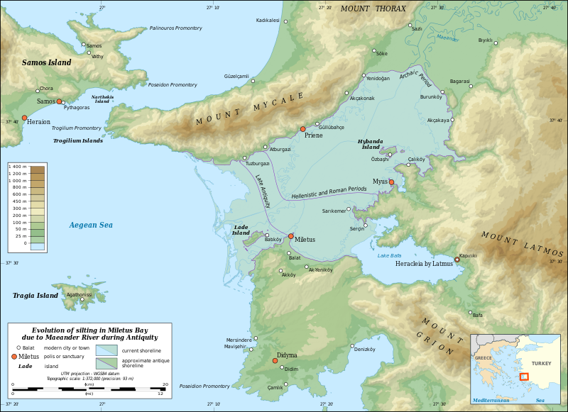
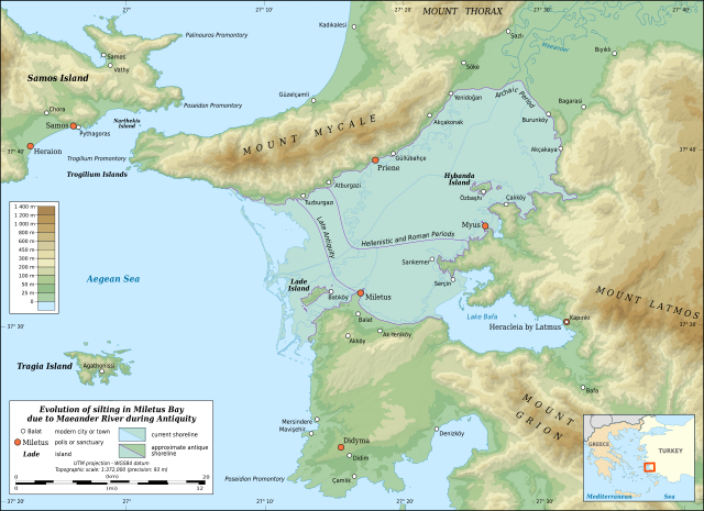
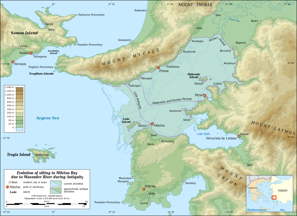
English: Map in English showing the silting evolution of Miletus Bay due to the alluvium brought by the Maeander River during Antiquity. Are also displayed some of the modern cities and towns of the area, the current course of the Maeander River and the current shoreline.
Notes:
Français : Carte en anglais de l'évolution de l'ensablement de la baie de Milet dû aux alluvions déposés par le Méandre. Sont aussi montrés le parcours actuel du Méandre, le littoral actuel et diverses agglomérations modernes. Notes :
UTM projection – WGS84 datum |
||
| 日期 | |||
| 来源 |
自己的作品
|
||
| 作者 | Eric Gaba (Sting - fr:Sting) | ||
| 授权 (二次使用本文件) |
|
||
| 其他版本 |
|


|
此SVG檔案包含可翻譯至您的語言的内嵌文字,可以使用任何可用SVG編輯器、文本編輯器或SVG翻譯工具來翻譯。詳情請見:關於翻譯SVG檔案。 |
许可协议
Eric Gaba, Wikimedia Commons user Sting,本作品著作权人,特此采用以下许可协议发表本作品:

|
已授权您依据自由软件基金会发行的无固定段落及封面封底文字(Invariant Sections, Front-Cover Texts, and Back-Cover Texts)的GNU自由文件许可协议1.2版或任意后续版本的条款,复制、传播和/或修改本文件。该协议的副本请见“GNU Free Documentation License”。 |
本文件采用知识共享署名-相同方式共享 3.0 未本地化版本许可协议授权。
署名: Eric Gaba, Wikimedia Commons user Sting
- 您可以自由地:
- 共享 – 复制、发行并传播本作品
- 修改 – 改编作品
- 惟须遵守下列条件:
- 署名 – 您必须对作品进行署名,提供授权条款的链接,并说明是否对原始内容进行了更改。您可以用任何合理的方式来署名,但不得以任何方式表明许可人认可您或您的使用。
- 相同方式共享 – 如果您再混合、转换或者基于本作品进行创作,您必须以与原先许可协议相同或相兼容的许可协议分发您贡献的作品。
您可以选择您需要的许可协议。
文件历史
点击某个日期/时间查看对应时刻的文件。
| 日期/时间 | 缩略图 | 大小 | 用户 | 备注 | |
|---|---|---|---|---|---|
| 当前 | 2010年7月16日 (五) 21:00 | | 1,857 × 1,349(1.54 MB) | Sting | Test: embedded sRGB profile |
| 2009年7月2日 (四) 12:22 |  | 1,857 × 1,349(1.59 MB) | Sting | == Summary == {{Location|37|35|00|N|27|16|00|E|scale:500000}} <br/> {{Information| |Description={{en|Map in English showing the silting evolution of Miletus Bay due to the alluvium brought by the [[:en:Büyük Menderes River|Maeander Rive |
文件用途
全域文件用途
以下其他wiki使用此文件:
- ar.wikipedia.org上的用途
- azb.wikipedia.org上的用途
- az.wikipedia.org上的用途
- bg.wikipedia.org上的用途
- ca.wikipedia.org上的用途
- ceb.wikipedia.org上的用途
- cs.wikipedia.org上的用途
- de.wikipedia.org上的用途
- de.wikivoyage.org上的用途
- el.wikipedia.org上的用途
- en.wikipedia.org上的用途
- Miletus
- Priene
- Battle of Mycale
- Didyma
- Büyük Menderes River
- Mycale
- Lake Bafa
- Battle of Lade (201 BCE)
- Myus
- Beşparmak Mountains
- Dilek Peninsula-Büyük Menderes Delta National Park
- Wikipedia:Featured picture candidates/October-2016
- Wikipedia:Featured picture candidates/Miletus Bay Silting Map
- User:Abyssal/bla
- Lydian–Milesian War
- es.wikipedia.org上的用途
- fa.wikipedia.org上的用途
- fi.wikipedia.org上的用途
- fr.wikipedia.org上的用途
- he.wikipedia.org上的用途
- hr.wikipedia.org上的用途
查看本文件的更多全域用途。