File:Montenegro Map.png

原始文件 (2,427 × 1,807像素,文件大小:1.03 MB,MIME类型:image/png)
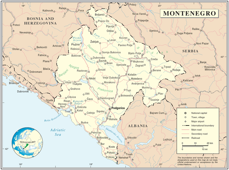
Map of Montenegro
| 描述 | Map of Montenegro | |||
| 日期 | ||||
| 来源 | The Cartographic Section of the United Nations (CSUN) | |||
| 作者 | Cartographer of the United Nations | |||
| 授权 (二次使用本文件) |
|

文件历史
点击某个日期/时间查看对应时刻的文件。
| 日期/时间 | 缩略图 | 大小 | 用户 | 备注 | |
|---|---|---|---|---|---|
| 当前 | 2007年3月10日 (六) 17:03 | | 2,427 × 1,807(1.03 MB) | Minestrone | Map of Montenegro {{Information |Description=Map of Montenegro |Source=The Cartographic Section of the United Nations (CSUN) |Date=2007-03-10 |Author=Cartographer of the United Nations |Permission={{Template:UN map}} and the cartographer of the UN [ |
文件用途
以下页面使用本文件:
全域文件用途
以下其他wiki使用此文件:
- als.wikipedia.org上的用途
- ar.wikipedia.org上的用途
- avk.wikipedia.org上的用途
- be-tarask.wikipedia.org上的用途
- bg.wikipedia.org上的用途
- cs.wikipedia.org上的用途
- cy.wikipedia.org上的用途
- de.wikipedia.org上的用途
- el.wikipedia.org上的用途
- en.wikipedia.org上的用途
- fa.wikipedia.org上的用途
- fr.wikipedia.org上的用途
- gag.wikipedia.org上的用途
- gd.wikipedia.org上的用途
- hr.wiktionary.org上的用途
- ia.wikipedia.org上的用途
- incubator.wikimedia.org上的用途
- io.wikipedia.org上的用途
- ka.wikipedia.org上的用途
- la.wikipedia.org上的用途
- ms.wikipedia.org上的用途
- nl.wikipedia.org上的用途
- pl.wikipedia.org上的用途
- pl.wiktionary.org上的用途
- pnb.wikipedia.org上的用途
- ps.wikipedia.org上的用途
- rm.wikipedia.org上的用途
- roa-tara.wikipedia.org上的用途
- ro.wikipedia.org上的用途
- ro.wikivoyage.org上的用途
- ru.wikipedia.org上的用途
查看本文件的更多全域用途。