File:Nagorno Karabakh03.png

本预览的尺寸:418 × 600像素。 其他分辨率:167 × 240像素 | 334 × 480像素 | 988 × 1,418像素。
原始文件 (988 × 1,418像素,文件大小:50 KB,MIME类型:image/png)
摘要
| 描述 |
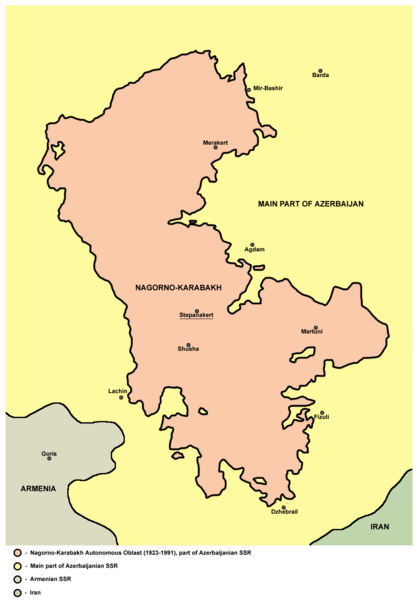
English: Nagorno-Karabakh Autonomous Oblast map. |
| 日期 | |
| 来源 | 自己的作品 |
| 作者 | user:PANONIAN |

|
This map has been uploaded by Electionworld from en.wikipedia.org to enable the |
| 我,本作品著作权人,释出本作品至公有领域。这适用于全世界。 在一些国家这可能不合法;如果是这样的话,那么: 我无条件地授予任何人以任何目的使用本作品的权利,除非这些条件是法律规定所必需的。 |
References
- http://www.karabakh.org/wp-content/uploads/2011/09/nagorno-karabakh.gif
- http://www.halotrust.org/Library/images/page_images/full_width/738_nagorno_karabakh.jpg
- http://www.acig.org/artman/uploads/map_nagorniy_karabakh.jpg
- http://sumgait.info/img/ethnic-cleansing-in-progress/nkr.gif
- http://1.bp.blogspot.com/-ykHF0dWo72U/TXwe8zLvO0I/AAAAAAAAAAM/UJlJxfMvxWg/s1600/nagornkarabah-1.gif
文件历史
点击某个日期/时间查看对应时刻的文件。
| 日期/时间 | 缩略图 | 大小 | 用户 | 备注 | |
|---|---|---|---|---|---|
| 当前 | 2023年12月13日 (三) 16:51 | | 988 × 1,418(50 KB) | Josemite | Reverted to version as of 19:29, 3 October 2020 (UTC) |
| 2020年12月10日 (四) 05:53 |  | 793 × 971(30 KB) | Nicolay Sidorov | ... | |
| 2020年12月10日 (四) 05:51 |  | 793 × 971(34 KB) | Nicolay Sidorov | new | |
| 2020年10月3日 (六) 19:29 |  | 988 × 1,418(50 KB) | Nicolay Sidorov | ooops! cities labels are forgot.. | |
| 2020年10月3日 (六) 19:22 |  | 988 × 1,418(48 KB) | Nicolay Sidorov | fully fixed borders (1988 actual) | |
| 2014年4月29日 (二) 09:58 |  | 988 × 1,418(66 KB) | PANONIAN | aesthetics | |
| 2012年6月25日 (一) 17:10 |  | 1,017 × 1,433(66 KB) | PANONIAN | improved my own work | |
| 2006年12月19日 (二) 19:51 |  | 898 × 1,112(39 KB) | Electionworld | {{ew|en|PANONIAN}} Nagorno-Karabakh map (self made) {{PD-self}} Category:Maps of Azerbaijan Category:Maps of Nagorno Karabakh |
文件用途
全域文件用途
以下其他wiki使用此文件:
- ar.wikipedia.org上的用途
- ast.wikipedia.org上的用途
- be-tarask.wikipedia.org上的用途
- bg.wikipedia.org上的用途
- bn.wikipedia.org上的用途
- br.wikipedia.org上的用途
- ca.wikipedia.org上的用途
- cs.wikipedia.org上的用途
- cy.wikipedia.org上的用途
- de.wikipedia.org上的用途
- dv.wikipedia.org上的用途
- el.wikipedia.org上的用途
- en.wikipedia.org上的用途
- en.wiktionary.org上的用途
- eo.wikipedia.org上的用途
- es.wikipedia.org上的用途
- fa.wikipedia.org上的用途
- fi.wikipedia.org上的用途
- fr.wikipedia.org上的用途
- gl.wikipedia.org上的用途
- he.wikipedia.org上的用途
- hu.wikipedia.org上的用途
- hy.wikipedia.org上的用途
- hyw.wikipedia.org上的用途
- id.wikipedia.org上的用途
查看本文件的更多全域用途。