File:Nova Scotia municipalities.png
本预览的尺寸:698 × 600像素。 其他分辨率:279 × 240像素 | 559 × 480像素 | 894 × 768像素 | 1,192 × 1,024像素 | 2,550 × 2,191像素。
原始文件 (2,550 × 2,191像素,文件大小:126 KB,MIME类型:image/png)
摘要
| 描述 |
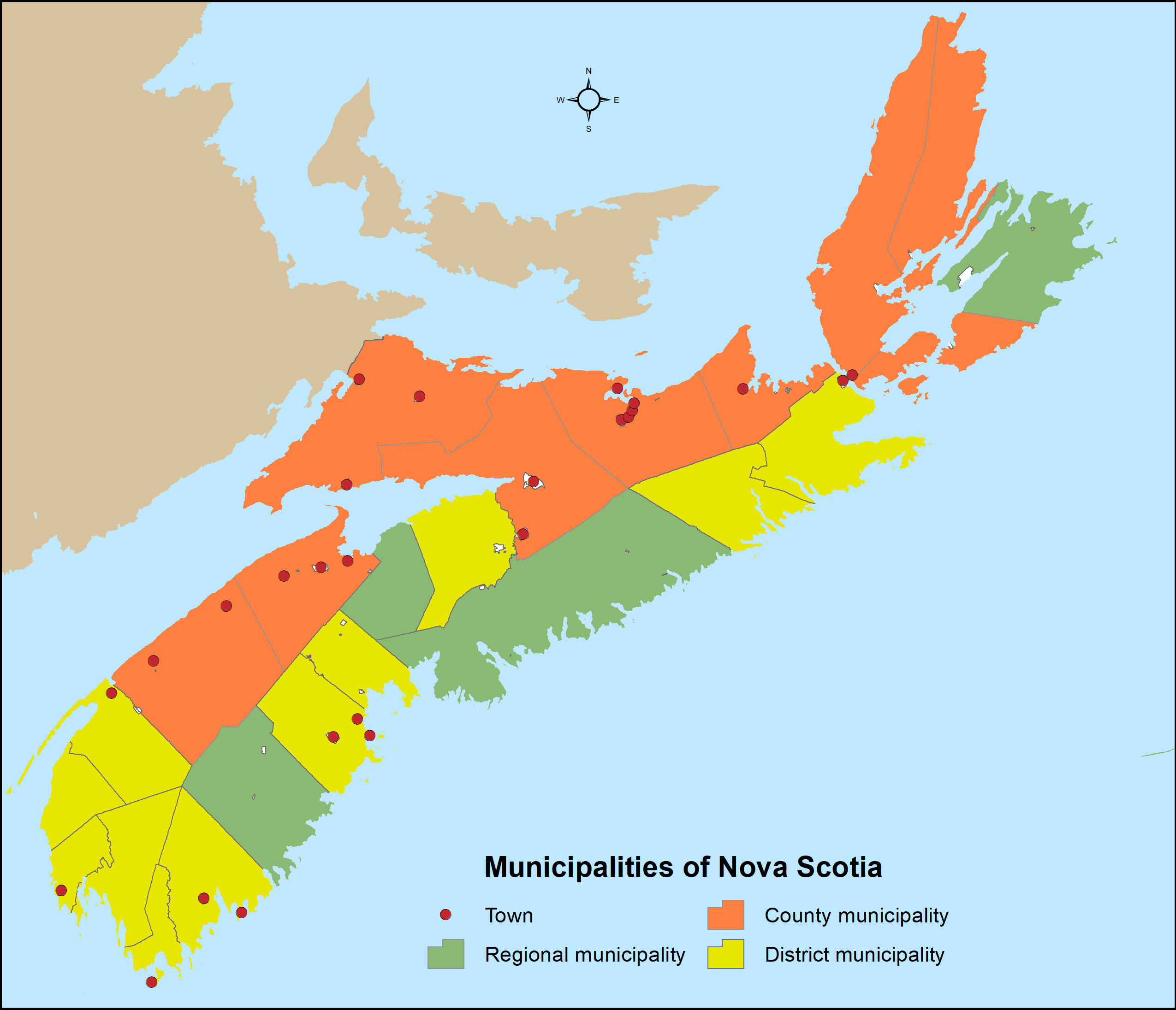
English: Distribution of Nova Scotia's 49 municipalities (4 regional municipalities, 9 county municipalities, 12 district municipalities and 25 towns) utilizing Statistics Canada's 2016 census subdivision boundaries. |
| 日期 | |
| 来源 | 自己的作品 |
| 作者 | Hwy43 |
许可协议
我,本作品著作权人,特此采用以下许可协议发表本作品:
本文件采用知识共享署名 3.0 未本地化版本许可协议授权。
- 您可以自由地:
- 共享 – 复制、发行并传播本作品
- 修改 – 改编作品
- 惟须遵守下列条件:
- 署名 – 您必须对作品进行署名,提供授权条款的链接,并说明是否对原始内容进行了更改。您可以用任何合理的方式来署名,但不得以任何方式表明许可人认可您或您的使用。
文件历史
点击某个日期/时间查看对应时刻的文件。
| 日期/时间 | 缩略图 | 大小 | 用户 | 备注 | |
|---|---|---|---|---|---|
| 当前 | 2021年7月31日 (六) 19:20 | | 2,550 × 2,191(126 KB) | Hwy43 | Revise to reflect the amalgamation of the Town of Windsor with the Municipality of the District of West Hants to form a new regional municipality named West Hants Regional Municipality.en |
| 2016年12月28日 (三) 09:00 |  | 816 × 701(31 KB) | Hwy43 | Reflect the dissolution of the former Town of Parrsboro | |
| 2016年12月8日 (四) 08:05 |  | 816 × 701(31 KB) | Hwy43 | return accidentally dissolved district municipality boundaries and fix background colour for Prince Edward Island | |
| 2016年12月7日 (三) 02:20 |  | 816 × 701(30 KB) | Hwy43 | hide dissolved towns of Canso and Hantsport and reveal Indian reserves | |
| 2016年1月2日 (六) 03:22 |  | 3,400 × 2,921(198 KB) | Hwy43 | remove towns dissolved since 2011 census | |
| 2016年1月1日 (五) 23:05 |  | 3,400 × 2,921(201 KB) | Hwy43 | Display only those nine historical counties that are incorporated as county municipalities (with symbology changes). | |
| 2016年1月1日 (五) 20:00 |  | 3,400 × 2,921(241 KB) | Hwy43 | User created page with UploadWizard |
文件用途
没有页面链接到本图像。
全域文件用途
以下其他wiki使用此文件:
- en.wikipedia.org上的用途