File:Nubia on al-Idrisi's map (12th century).jpg
此为最大尺寸。
Nubia_on_al-Idrisi's_map_(12th_century).jpg (453 × 577像素,文件大小:209 KB,MIME类型:image/jpeg)
.jpg?uselang=zh)
.jpg?uselang=zh)
.jpg?action=history&uselang=zh)
.jpg)
摘要
| 描述 |
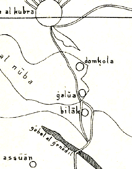
English: Nubia on al-Idrisi's small map (1192), which swaps north and south. The map contains several errors, like placing Makuria (domkola) south of Alodia (galua) or placing Philae (Bilak) in the area between the Nile and the Atbara river, although it should be located just south of Assuan. Further reading: https://journals.openedition.org/afriques/807 |
| 日期 | |
| 来源 | Die kleine Idrisikarte vom Jahr 1192 n. Chr. |
| 作者 | Konrad Miller |
许可协议
|
本作品在其来源国以及其他著作权期限是作者逝世后70年或以下的国家和地区属于公有领域。 | |
| 本文件已被确认为免除已知的著作权法限制(包括所有相关权利)。 | |
文件历史
点击某个日期/时间查看对应时刻的文件。
| 日期/时间 | 缩略图 | 大小 | 用户 | 备注 | |
|---|---|---|---|---|---|
| 当前 | 2018年9月17日 (一) 15:07 | | 453 × 577(209 KB) | LeGabrie | User created page with UploadWizard |
文件用途
以下页面使用本文件:
全域文件用途
以下其他wiki使用此文件:
- en.wikipedia.org上的用途
- pt.wikipedia.org上的用途
- vi.wikipedia.org上的用途
.jpg)