File:Overview of the Gale Crater Landing Site.jpg

本预览的尺寸:430 × 600像素。 其他分辨率:172 × 240像素 | 344 × 480像素 | 551 × 768像素 | 734 × 1,024像素 | 1,469 × 2,048像素 | 3,856 × 5,376像素。
原始文件 (3,856 × 5,376像素,文件大小:3.8 MB,MIME类型:image/jpeg)
摘要
| 描述 |
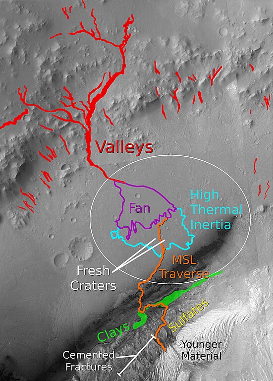
English: This graphic shows key features at the MSL landing site in Gale crater. A possible traverse path is shown in orange. Branching valleys from the crater wall lead to an alluvial fan in the center of the ellipse. At the end of the alluvial fan, the terrain transitions to a fractured, layered unit with a high thermal inertia. Several fresh craters in this unit are accessible. The primary target of the mission is the clay-bearing unit on the lower portion of the layered central mound, and its transition to the overlying sulfate-bearing layers. Cemented fractures in the sulfate-bearing rocks suggest groundwater interactions. A light-toned lens of younger material, heavily eroded by wind, marks the end of the notional traverse. |
| 日期 | |
| 来源 | The basemap for this image is a mosaic of images from the Context Camera (CTX) on the Mars Reconnaissance Orbiter (MRO). Clay and sulfate units are based on mineral parameter maps generated by Milliken et al., 2010 using data from the Compact Reconnaissance Imaging Spectrometer for Mars (CRISM) on MRO. Other units and features are adapted from Anderson and Bell, 2010 |
| 作者 | Ryan Anderson |
许可协议
我,本作品著作权人,特此采用以下许可协议发表本作品:
本文件采用知识共享署名-相同方式共享 3.0 未本地化版本许可协议授权。
- 您可以自由地:
- 共享 – 复制、发行并传播本作品
- 修改 – 改编作品
- 惟须遵守下列条件:
- 署名 – 您必须对作品进行署名,提供授权条款的链接,并说明是否对原始内容进行了更改。您可以用任何合理的方式来署名,但不得以任何方式表明许可人认可您或您的使用。
- 相同方式共享 – 如果您再混合、转换或者基于本作品进行创作,您必须以与原先许可协议相同或相兼容的许可协议分发您贡献的作品。
文件历史
点击某个日期/时间查看对应时刻的文件。
| 日期/时间 | 缩略图 | 大小 | 用户 | 备注 | |
|---|---|---|---|---|---|
| 当前 | 2011年7月30日 (六) 02:41 | | 3,856 × 5,376(3.8 MB) | RyanA1084 |
文件用途
以下页面使用本文件:
全域文件用途
以下其他wiki使用此文件:
- ca.wikipedia.org上的用途
- hr.wikipedia.org上的用途
- ja.wikipedia.org上的用途
- sr.wikipedia.org上的用途