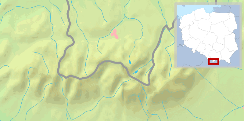
File:POL Tatry.svg

此SVG文件的PNG预览的大小:800 × 396像素。 其他分辨率:320 × 158像素 | 640 × 316像素 | 1,024 × 506像素 | 1,280 × 633像素 | 2,560 × 1,266像素 | 811 × 401像素。
原始文件 (SVG文件,尺寸为811 × 401像素,文件大小:5.36 MB)
| 描述 |
English: Map of the Tatra Mountains Polski: Mapa Tatr |
| 日期 | (UTC) |
| 来源 | |
| 作者 |
|
| 其他版本 |
|
| SVG开发 |


本文件采用知识共享署名-相同方式共享 3.0 未本地化版本许可协议授权。
- 您可以自由地:
- 共享 – 复制、发行并传播本作品
- 修改 – 改编作品
- 惟须遵守下列条件:
- 署名 – 您必须对作品进行署名,提供授权条款的链接,并说明是否对原始内容进行了更改。您可以用任何合理的方式来署名,但不得以任何方式表明许可人认可您或您的使用。
- 相同方式共享 – 如果您再混合、转换或者基于本作品进行创作,您必须以与原先许可协议相同或相兼容的许可协议分发您贡献的作品。
原始上传日志
This image is a derivative work of the following images:
- File:Tatry mapa 2.png licensed with PD-Demis
- 2008-09-02T21:41:25Z ToSter 811x401 (305387 Bytes) {{Information |Description={{en|1=Map of the Tatra Mountains}} {{pl|1=Mapa Tatr}} |Source=PD map from Demis - modified version of [[:Image:Tatry mapa.png]] by [[User:Botev]] |Author=[[User:ToSter|ToSter]] |Date=Sep 2nd, 2008
- File:Poland location map white.svg licensed with Cc-by-sa-3.0, Cc-by-sa-3.0/en
- 2009-01-29T00:51:50Z Mareklug 862x838 (358904 Bytes) {{Information |Description={{de| Positionskarte von Polen auf weissem Hintergrund. Quadratische Plattkarte, N-S-Streckung 160 %. Geographische Begrenzung der Karte: * N: 55.2° N * S: 48.7° N * W: 13.8° O * O: 24.5° O {{en
Uploaded with derivativeFX
文件历史
点击某个日期/时间查看对应时刻的文件。
| 日期/时间 | 缩略图 | 大小 | 用户 | 备注 | |
|---|---|---|---|---|---|
| 当前 | 2009年2月11日 (三) 10:30 | | 811 × 401(5.36 MB) | Mareklug | pozycjonowanie w górnym rogu na życzenie, ramka (subtelna, półprzezroczysta) / positioning in upper corner on request, border (a suttle, semi-transparent one) |
| 2009年2月11日 (三) 03:19 |  | 811 × 401(5.36 MB) | Mareklug | repositioned the POL white map miniature to the lower right corner, because it was occluding some of Poland. Now both Tatry maps that are national variants use that corner (SVK Tatry.svg & POL Tatry.svg) | |
| 2009年2月10日 (二) 13:32 |  | 811 × 401(5.19 MB) | Mareklug | {{Information |Description={{en|1=Map of the Tatra Mountains}} {{pl|1=Mapa Tatr}} |Source=*File:Tatry_mapa_2.png *File:Poland_location_map_white.svg |Date=2009-02-10 13:28 (UTC) |Author=*File:Tatry_mapa_2.png: ToSter |Dat |
文件用途
以下页面使用本文件:
全域文件用途
以下其他wiki使用此文件:
- de.wikivoyage.org上的用途
- en.wikipedia.org上的用途
- fy.wikipedia.org上的用途
- ko.wikipedia.org上的用途
- pl.wikipedia.org上的用途
- Giewont
- Rysy
- Tatry
- Starorobociański Wierch
- Kozi Wierch
- Liliowe (przełęcz)
- Świnica
- Granaty
- Morskie Oko
- Czarny Staw Gąsienicowy
- Wodogrzmoty Mickiewicza
- Mnich (Tatry)
- Żabi Mnich
- Zadni Mnich
- Niżnie Rysy
- Żabi Szczyt Wyżni
- Żabi Szczyt Niżni
- Żabi Koń
- Mięguszowiecka Przełęcz pod Chłopkiem
- Kazalnica Mięguszowiecka
- Cubryna
- Wrota Chałubińskiego
- Szpiglasowa Przełęcz
- Szpiglasowy Wierch
- Miedziane (Tatry)
- Opalony Wierch
- Gładki Wierch
- Gładka Przełęcz
- Kasprowy Wierch
- Walentkowy Wierch
- Zawrat
- Mały Kozi Wierch
- Zmarzła Przełęcz
- Zamarła Turnia
- Kozia Przełęcz
- Kozie Czuby
- Czarne Ściany
- Orla Baszta
- Buczynowe Czuby
- Krzyżne
- Żółta Turnia
- Roztocka Czuba
- Wierch pod Fajki
- Czarny Staw pod Rysami
- Wielki Staw Polski
- Zadni Staw Polski
查看此文件的更多全域用途。