File:Qattara depression map.png
Qattara_depression_map.png (599 × 435像素,文件大小:54 KB,MIME类型:image/png)

|
此locator map图片可使用矢量图形重新创建为SVG文件。这具有很多好处;更多信息请参见共享资源:待清理媒体。如果存在此图片的SVG格式,请将其上传,然后将此模板替换为
{{vector version available|新图片名称}}。
建议您将SVG命名为“Qattara depression map.svg”,这样在使用Vector version available(或Vva)模板时就不需要填写新图片名称参数。 |
| 描述 | |
| 日期 | 2005年5月20日 (原始上传日期) |
| 来源 | Adapted from https://www.un.org/geospatial/content/egypt and en:Image:Eg-map.png |
| 作者 | 原上传者为英语维基百科的ChrisO |
许可协议
| This image is a map derived from a United Nations map.
Unless stated otherwise, UN maps are to be considered in the public domain. This applies worldwide. UN maps are, in principle, open source material and you can use them in your work or for making your own map. UN requests however that you delete the UN name, logo and reference number upon any modification to the map. Content of your map will be your responsibility. You can state in your publication, if you wish, something like: based on UN map … (map name, map number, revision number and date). See: Geospatial Information Section. And: Geospatial, location data for a better world. |
 |
原始上传日志
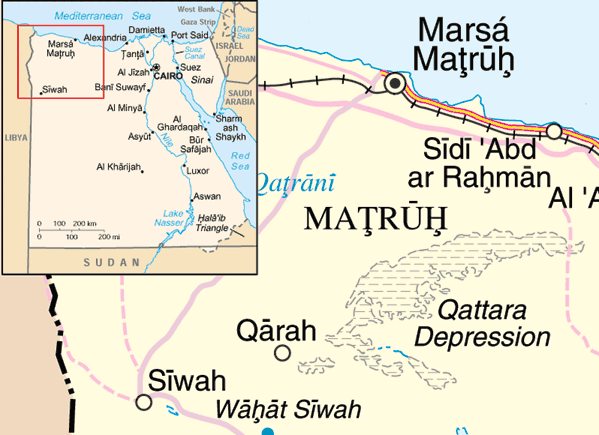
- 2005-05-20 22:10 ChrisO 599×435× (54888 bytes) Map of the [[Qattara Depression]], [[Egypt]] Adapted from http://www.un.org/Depts/Cartographic/map/profile/egypt.pdf and [[:Image:Eg-map.png]] {{UN map}}
文件历史
点击某个日期/时间查看对应时刻的文件。
| 日期/时间 | 缩略图 | 大小 | 用户 | 备注 | |
|---|---|---|---|---|---|
| 当前 | 2009年3月31日 (二) 12:29 | | 599 × 435(54 KB) | File Upload Bot (Magnus Manske) | {{BotMoveToCommons|en.wikipedia|year={{subst:CURRENTYEAR}}|month={{subst:CURRENTMONTHNAME}}|day={{subst:CURRENTDAY}}}} {{Information |Description={{en|Map of the en:Qattara Depression, en:Egypt Adapted from http://www.un.org/Depts/Cartographic |
文件用途
以下页面使用本文件:
全域文件用途
以下其他wiki使用此文件:
- ar.wikipedia.org上的用途
- arz.wikipedia.org上的用途
- cs.wikipedia.org上的用途
- da.wikipedia.org上的用途
- en.wikipedia.org上的用途
- eo.wikipedia.org上的用途
- es.wikipedia.org上的用途
- fa.wikipedia.org上的用途
- fi.wikipedia.org上的用途
- fr.wikipedia.org上的用途
- ga.wikipedia.org上的用途
- hr.wikipedia.org上的用途
- id.wikipedia.org上的用途
- ml.wikipedia.org上的用途
- my.wikipedia.org上的用途
- no.wikipedia.org上的用途
- uk.wikipedia.org上的用途
- ur.wikipedia.org上的用途
- vi.wikipedia.org上的用途
- war.wikipedia.org上的用途
- zu.wikipedia.org上的用途