File:Quercus macrocarpa range map 1.png
本预览的尺寸:600 × 600像素。 其他分辨率:240 × 240像素 | 480 × 480像素 | 768 × 768像素 | 1,024 × 1,024像素 | 2,048 × 2,048像素。
原始文件 (2,048 × 2,048像素,文件大小:135 KB,MIME类型:image/png)
摘要
| 描述 |
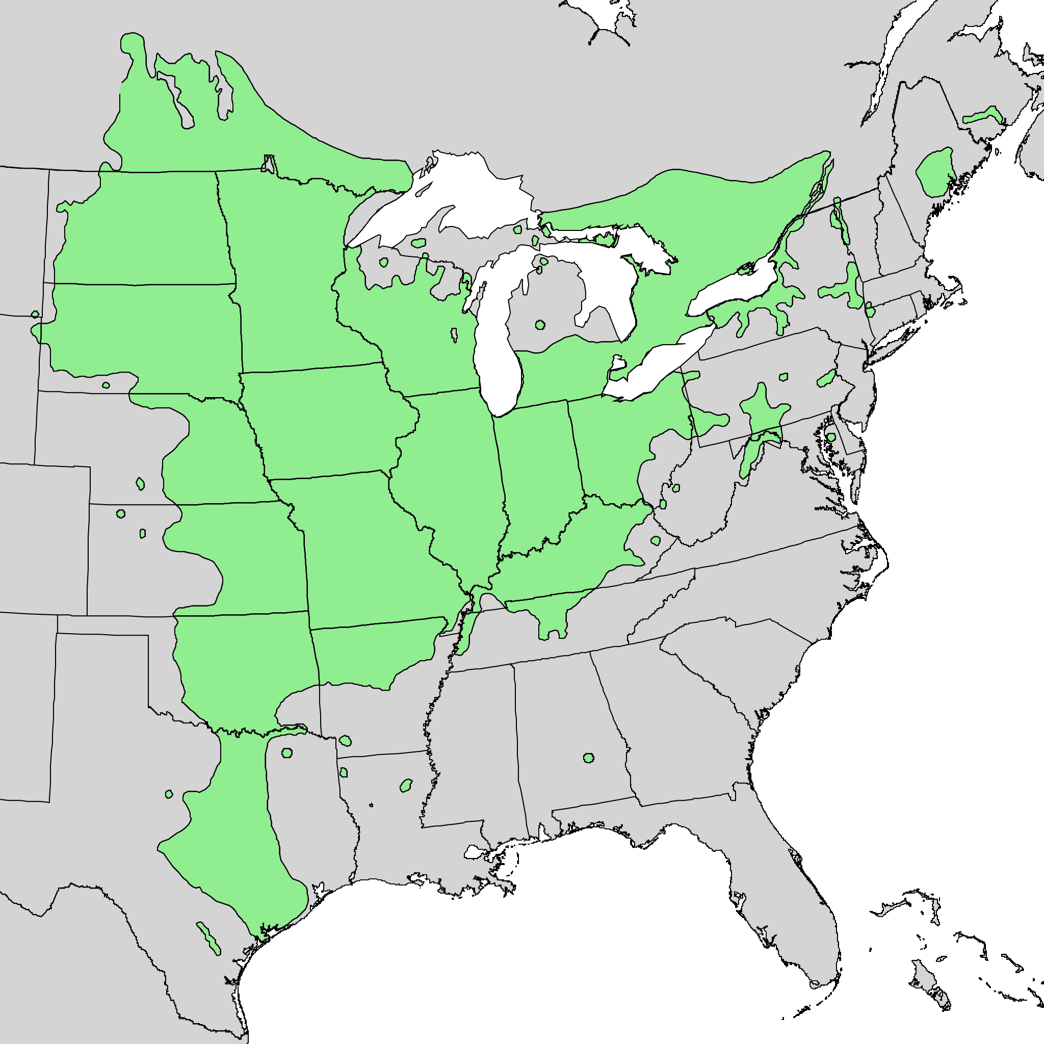
English: Range map of Quercus macrocarpa. |
| 日期 | |
| 来源 | Digital representation of "Atlas of United States Trees" by Elbert L. Little, Jr. [1] |
| 作者 | U.S. Geological Survey |
许可协议
|
|
原始上传日志
本檔案是由Quadell使用CommonsHelper,從en.wikipedia轉移到維基共享資源。
原始描述頁面位於這裡。下列使用者名稱均來自en.wikipedia。
- 2010-05-21 03:22 Masebrock 743×612× (139721 bytes) {{Information |Description=Range map of Quercus marcocarpa |Source=Digital representation of "Atlas of United States Trees" by Elbert L. Little, Jr. [http://esp.cr.usgs.gov/data/atlas/little/] |Date=1999 |Author=U.S. Geological Survey |Permission={{PD-US
文件历史
点击某个日期/时间查看对应时刻的文件。
| 日期/时间 | 缩略图 | 大小 | 用户 | 备注 | |
|---|---|---|---|---|---|
| 当前 | 2013年10月20日 (日) 20:40 | | 2,048 × 2,048(135 KB) | Nonenmac | Doubled the resolution so that more of the little green circles contain green instead of just black |
| 2013年10月18日 (五) 14:47 |  | 1,024 × 1,024(45 KB) | Nonenmac | larger png version without the vertical striping, directly from the same USGS source | |
| 2011年9月7日 (三) 20:43 |  | 743 × 612(136 KB) | File Upload Bot (Magnus Manske) | {{BotMoveToCommons|en.wikipedia|year={{subst:CURRENTYEAR}}|month={{subst:CURRENTMONTHNAME}}|day={{subst:CURRENTDAY}}}} {{Information |Description={{en|Range map of Quercus marcocarpa}} |Source=Transferred from [http://en.wikipedia.org en.wikipedia]; tran |
文件用途
以下页面使用本文件:
全域文件用途
以下其他wiki使用此文件:
- ar.wikipedia.org上的用途
- arz.wikipedia.org上的用途
- ca.wikipedia.org上的用途
- ceb.wikipedia.org上的用途
- cs.wikipedia.org上的用途
- en.wikipedia.org上的用途
- es.wikipedia.org上的用途
- fa.wikipedia.org上的用途
- hu.wikipedia.org上的用途
- is.wikipedia.org上的用途
- it.wikipedia.org上的用途
- ka.wikipedia.org上的用途
- no.wikipedia.org上的用途
- pl.wikipedia.org上的用途
- ru.wikipedia.org上的用途
- sv.wikipedia.org上的用途
- uk.wikipedia.org上的用途
- vi.wikipedia.org上的用途
- www.wikidata.org上的用途