File:Range map Tapirus bairdii with borders.png
此为最大尺寸。
Range_map_Tapirus_bairdii_with_borders.png (338 × 419像素,文件大小:8 KB,MIME类型:image/png)
摘要
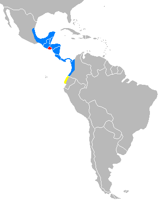
| 描述 | Distribution of Tapirus bairdii with national borders added |
| 日期 | |
| 来源 | 自己的作品 |
| 作者 | tr:Kullanıcı:Mskyrider |
Explications
Created from the information on [1] archive copy at the Wayback Machine. In red El Salvador where Baird's Tapir is extinct. In yellow Ecuador where Baird's Tapir presence is unconfirmed. In blue actual distribution.
许可协议
| 我,本作品著作权人,释出本作品至公有领域。这适用于全世界。 在一些国家这可能不合法;如果是这样的话,那么: 我无条件地授予任何人以任何目的使用本作品的权利,除非这些条件是法律规定所必需的。 |
文件历史
点击某个日期/时间查看对应时刻的文件。
| 日期/时间 | 缩略图 | 大小 | 用户 | 备注 | |
|---|---|---|---|---|---|
| 当前 | 2019年7月12日 (五) 10:59 | | 338 × 419(8 KB) | Prosfilaes | Reverted to version as of 20:51, 24 February 2007 (UTC) |
| 2019年7月9日 (二) 19:02 |  | 338 × 419(17 KB) | Thylacinus cynocephalus | Removed unnecessary borders | |
| 2007年2月24日 (六) 20:51 |  | 338 × 419(8 KB) | Mskyrider | == Summary == {{Information |Description=Distribution of ''Tapirus bairdii'' |Source=own work |Date=24 Şubat 2007 |Author=tr:Kullanıcı:Mskyrider |Permission= |other_versions= }} ==Explications== Created from the information on [http://www.tapirs. |
文件用途
以下页面使用本文件:
全域文件用途
以下其他wiki使用此文件:
- ar.wikipedia.org上的用途
- avk.wikipedia.org上的用途
- br.wikipedia.org上的用途
- ceb.wikipedia.org上的用途
- cs.wikipedia.org上的用途
- da.wikipedia.org上的用途
- de.wikipedia.org上的用途
- en.wikipedia.org上的用途
- es.wikipedia.org上的用途
- eu.wikipedia.org上的用途
- fa.wikipedia.org上的用途
- fi.wikipedia.org上的用途
- fr.wikipedia.org上的用途
- gl.wikipedia.org上的用途
- he.wikipedia.org上的用途
- hr.wikipedia.org上的用途
- hu.wikipedia.org上的用途
- id.wikipedia.org上的用途
- it.wikipedia.org上的用途
- ja.wikipedia.org上的用途
- ka.wikipedia.org上的用途
- ko.wikipedia.org上的用途
- lv.wikipedia.org上的用途
- mn.wikipedia.org上的用途
- ms.wikipedia.org上的用途
- nl.wikipedia.org上的用途
- no.wikipedia.org上的用途
- nv.wikipedia.org上的用途
- pl.wikipedia.org上的用途
- pt.wikipedia.org上的用途
- ru.wikipedia.org上的用途
- sco.wikipedia.org上的用途
- sh.wikipedia.org上的用途
- simple.wikipedia.org上的用途
- sv.wikipedia.org上的用途
- th.wikipedia.org上的用途
- tr.wikipedia.org上的用途
- uk.wikipedia.org上的用途
- vi.wikipedia.org上的用途