File:Rif Damashq.svg

此SVG文件的PNG预览的大小:800 × 523像素。 其他分辨率:320 × 209像素 | 640 × 418像素 | 1,024 × 670像素 | 1,280 × 837像素 | 2,560 × 1,674像素 | 1,485 × 971像素。
原始文件 (SVG文件,尺寸为1,485 × 971像素,文件大小:7.38 MB)

摘要
| 描述 |
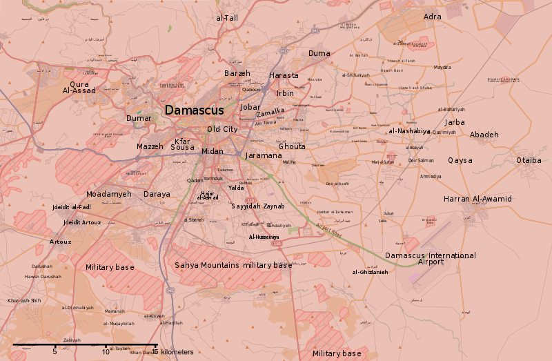
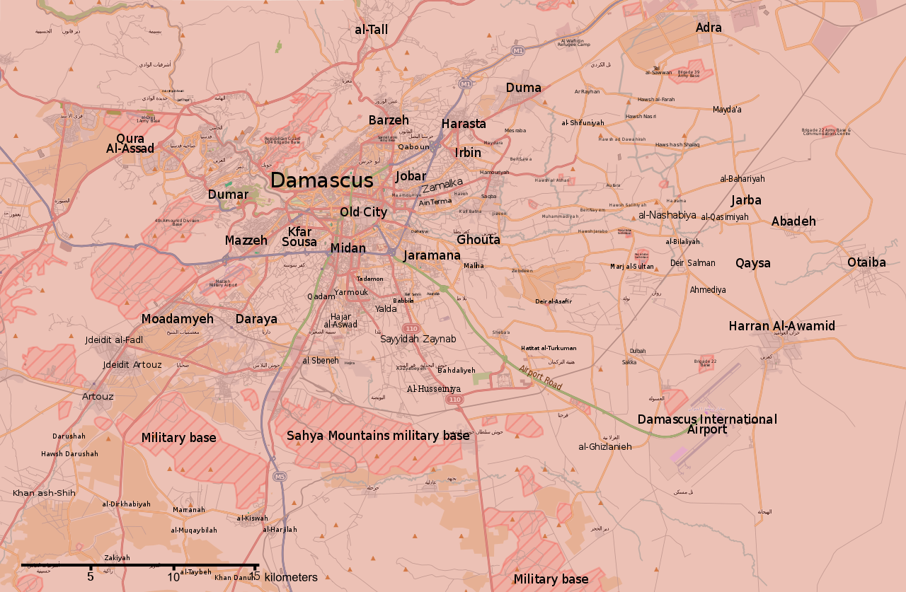
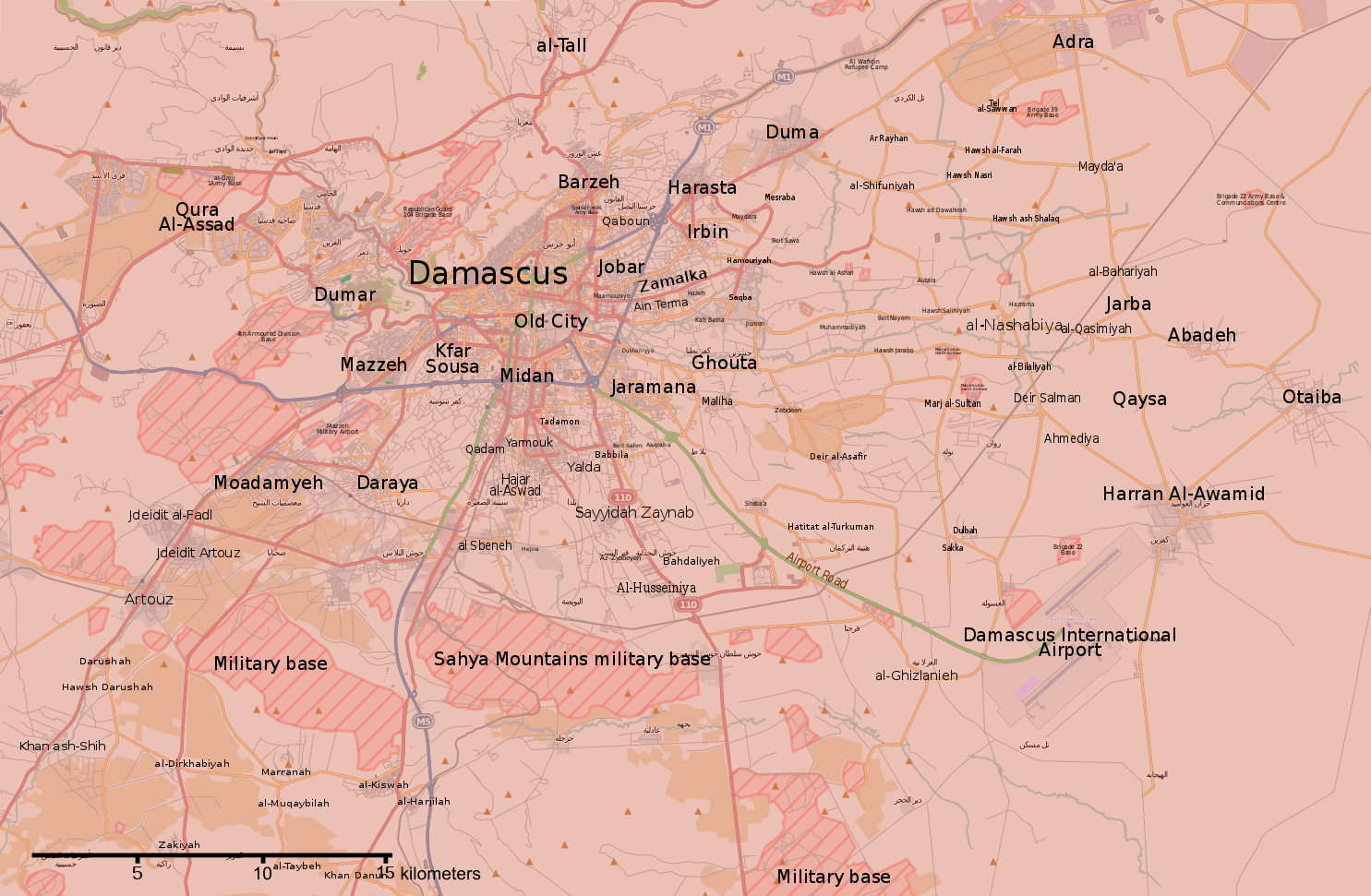
English: Map of the situation in Damascus and Rif Damashq during the Syrian Civil War.
English: Controlled by the Syrian Government
Controlled by the Syrian opposition
Controlled by the Islamic State of Iraq and the Levant
Truce/ceasefire zones
Contested/unclear situation العربية: خريطة الوضع في دمشق وريف دمشق خلال الحرب الأهلية السورية
تسيطر عليها الحكومة السورية
تسيطر عليها المعارضة السورية
تسيطر عليها تنظيم الدولة الإسلامية
مناطق الهدنة/وقف إطلاق النار
الحالة المتنازع عليها/غير الواضحة |
||||
| 日期 | |||||
| 来源 | File:Rif Dimashq offensive (September 2013).svg | ||||
| 作者 | MrPenguin20 | ||||
| 其他版本 |
|
||||
| SVG开发 |


.svg)

.png)


.svg)


.svg)


_Territory_Change_2014-2016.gif)

_(within_Northern_Syria).svg)


.png)
.svg)


_map.png)
.svg)


.svg)


.svg)
许可协议
| 此作品内含来自OpenStreetMap贡献者的地图资料,以开放数据库许可证(ODbL)释出。
对于从ODbL数据生成的地图,ODbL不需要任何特定许可。在2020年8月1日之前,OpenStreetMap基金会制作的地图图块已根据CC-BY-SA-2.0许可证授权。其他人制作的地图可能需要获得其他许可。 |
本文件采用知识共享署名-相同方式共享 3.0 未本地化版本许可协议授权。
- 您可以自由地:
- 共享 – 复制、发行并传播本作品
- 修改 – 改编作品
- 惟须遵守下列条件:
- 署名 – 您必须对作品进行署名,提供授权条款的链接,并说明是否对原始内容进行了更改。您可以用任何合理的方式来署名,但不得以任何方式表明许可人认可您或您的使用。
- 相同方式共享 – 如果您再混合、转换或者基于本作品进行创作,您必须以与原先许可协议相同或相兼容的许可协议分发您贡献的作品。
文件历史
点击某个日期/时间查看对应时刻的文件。
| 日期/时间 | 缩略图 | 大小 | 用户 | 备注 | |
|---|---|---|---|---|---|
| 当前 | 2018年5月22日 (二) 02:15 | | 1,485 × 971(7.38 MB) | Kami888 | damascus cleared |
| 2018年5月8日 (二) 05:56 |  | 1,485 × 971(7.38 MB) | Kami888 | updates | |
| 2018年5月4日 (五) 18:00 |  | 1,485 × 971(7.38 MB) | Kami888 | Evacuation of HTS and other non-ISIS rebels, ISIS pocket reported to be split in two. | |
| 2018年4月29日 (日) 18:41 |  | 1,485 × 971(7.39 MB) | Kami888 | ISIS withdrew from Qadam http://www.syriahr.com/en/?p=90681 | |
| 2018年4月26日 (四) 13:34 |  | 1,485 × 971(7.39 MB) | Kami888 | Taking update from https://pbs.twimg.com/media/Dbp4AVbX0AAxqSe.jpg:large as the only source that I know of that reports on situation in south damascus | |
| 2018年4月14日 (六) 02:42 |  | 1,485 × 971(7.39 MB) | Kami888 | Army of Islam evacuated from Douma | |
| 2018年4月1日 (日) 23:19 |  | 1,485 × 971(7.45 MB) | Kami888 | FAR and HTS evacuated to Idlib http://www.syriahr.com/2018/03/31/%d8%a8%d8%a7%d8%b3%d8%aa%d8%ab%d9%86%d8%a7%d8%a1-%d8%af%d9%88%d9%85%d8%a7-%d9%82%d9%88%d8%a7%d8%aa-%d8%a7%d9%84%d9%86%d8%b8%d8%a7%d9%85-%d8%aa%d9%81%d8%b1%d8%b6-%d8%b3%d9%8a%d8%b7%d8%b1%d8%aa/ | |
| 2018年3月27日 (二) 03:16 |  | 1,485 × 971(7.71 MB) | Kami888 | Changed Harasta to red per suggestion on talk page. Other towns still evacuating. | |
| 2018年3月25日 (日) 10:43 |  | 1,485 × 971(7.76 MB) | Kami888 | Changed Ein Terma/Hazeh. Evacuation from the other towns still appears to be ongoing. | |
| 2018年3月20日 (二) 12:00 |  | 1,485 × 971(7.77 MB) | Kami888 | south Qadam to contested |
文件用途
全域文件用途
以下其他wiki使用此文件:
- ar.wikipedia.org上的用途
- be.wikipedia.org上的用途
- en.wikipedia.org上的用途
- es.wikipedia.org上的用途
- fa.wikipedia.org上的用途
- fo.wikipedia.org上的用途
- hu.wikipedia.org上的用途
- hy.wikipedia.org上的用途
- id.wikipedia.org上的用途
- ko.wikipedia.org上的用途
- ku.wikipedia.org上的用途
- pa.wikipedia.org上的用途
- pl.wikipedia.org上的用途
- pt.wikipedia.org上的用途
- ru.wikipedia.org上的用途
- tr.wikipedia.org上的用途
- www.wikidata.org上的用途