File:Rojava february2014.png

本预览的尺寸:800 × 405像素。 其他分辨率:320 × 162像素 | 640 × 324像素 | 1,124 × 569像素。
原始文件 (1,124 × 569像素,文件大小:54 KB,MIME类型:image/png)
摘要
| 描述 |
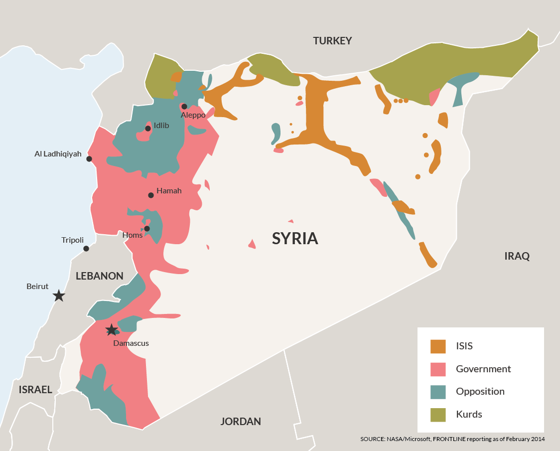
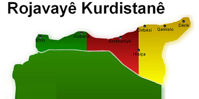
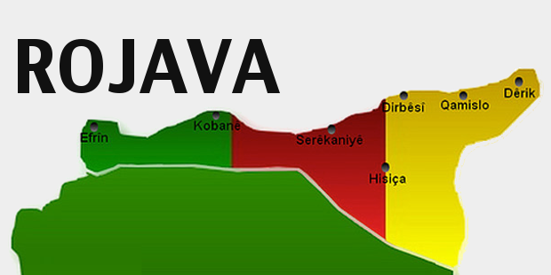
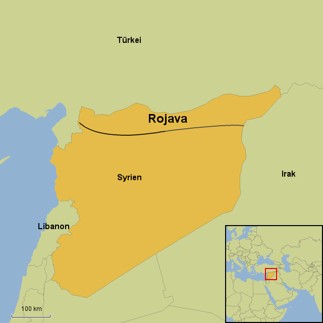
English: Map showing de facto cantons of Rojava (Western Kurdistan) in February 2014, as well as territories claimed by Rojava (Western Kurdistan), but not controlled by the Kurds in February 2014. |
| 日期 | |
| 来源 | 自己的作品 |
| 作者 | PANONIAN |
许可协议
我,本作品著作权人,特此采用以下许可协议发表本作品:
| 本作品采用知识共享CC0 1.0 通用公有领域贡献许可协议授权。 | |
| 采用本宣告发表本作品的人,已在法律允许的范围内,通过在全世界放弃其对本作品拥有的著作权法规定的所有权利(包括所有相关权利),将本作品贡献至公有领域。您可以复制、修改、传播和表演本作品,将其用于商业目的,无需要求授权。
|
References
Cantons of Rojava (Western Kurdistan) and frontline situation in February 2014:
- http://civiroglu.net/the-constitution-of-the-rojava-cantons/
- http://www.the-american-interest.com/wp-content/uploads/2014/02/syria_battlelines.png
Claimed borders of Rojava (Western Kurdistan):
- http://www.pydrojava.net/en/index.php/kurds-in-west-of-kurdistan/21-list-of-names-of-kurdish-parties-in-west-of-kurdistan
- http://www.pydrojava.net/en/images/west_kurdistan/2013/10/1268440_705746996107027_1388773568_o.jpg
- http://www.pydrojava.net/eng/index.php/kurds-in-west-of-kurdistan/21-list-of-names-of-kurdish-parties-in-west-of-kurdistan archive copy at the Wayback Machine
- http://www.pydrojava.net/eng/images/west_kurdistan/2013/10/1268440_705746996107027_1388773568_o.jpg
- http://freedomroad.org/2014/05/the-revolution-in-rojava/?___p
- http://freedomroad.org/wp-content/uploads/2014/05/kurdistan-map.jpg
- http://www.kurder.dk/nuce/wp-content/uploads/2013/08/rojava.jpg
- http://galeri7.uludagsozluk.com/250/rojava_466585.jpg
- http://rojhelat.info/en/wp-content/uploads/2013/09/rojava-map.png
- http://www.timeturk.com/resim/tr/2013/11/18/rojava-kurdistani-ni-taniyacagiz.jpg
- http://rojhelat.info/en/wp-content/uploads/2013/11/rojava1.jpg
- http://www.kurdistan-post.eu/sites/default/files/styles/large/public/field/image/rojava_21.png?itok=VN8Tg2cO
- http://3.bp.blogspot.com/-or5CLme9lfQ/UJ28cGJsttI/AAAAAAAAAFc/Fb3FZkkz1ek/s1600/5709807449_285d7caef9_b.jpg
- http://www.stepmap.de/landkarte/rojava-1372442.png
文件历史
点击某个日期/时间查看对应时刻的文件。
| 日期/时间 | 缩略图 | 大小 | 用户 | 备注 | |
|---|---|---|---|---|---|
| 当前 | 2014年9月30日 (二) 16:40 | | 1,124 × 569(54 KB) | PANONIAN | {{Information |Description ={{en|1=Map showing de facto cantons of Western Kurdistan (Rojava) in February 2014, as well as territories claimed by Western Kurdistan (Rojava), but not controlled by the Kurds in February 2014.}} |Source ={{own}... |
文件用途
全域文件用途
以下其他wiki使用此文件:
- ar.wikipedia.org上的用途
- ckb.wikipedia.org上的用途
- cs.wikipedia.org上的用途
- de.wikipedia.org上的用途
- en.wikipedia.org上的用途
- fr.wikipedia.org上的用途
- ku.wikipedia.org上的用途
- pt.wikipedia.org上的用途
- ro.wikipedia.org上的用途
- ru.wikipedia.org上的用途
- sh.wikipedia.org上的用途
- sr.wikipedia.org上的用途