File:San Nicholas Island California military facilities.png
此为最大尺寸。
San_Nicholas_Island_California_military_facilities.png (734 × 385像素,文件大小:353 KB,MIME类型:image/png)

文件历史
点击某个日期/时间查看对应时刻的文件。
| 日期/时间 | 缩略图 | 大小 | 用户 | 备注 | |
|---|---|---|---|---|---|
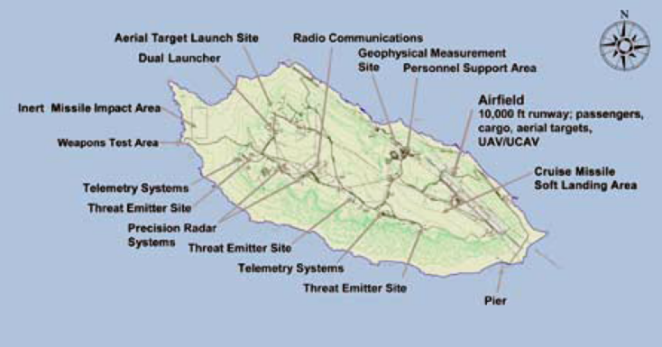
| 当前 | 2010年8月21日 (六) 15:53 | | 734 × 385(353 KB) | Cobatfor | == {{int:filedesc}} == {{Information |Description=Map showing the military facilities on San Nicolas Island, California (USA). |Source=U.S. Navy NAVAIR San Nicolas Island factsheet (NAVAIR Public Release 09-153) [http://www.navair.navy.mil/ranges/SEA/docs |
文件用途
以下页面使用本文件:
全域文件用途
以下其他wiki使用此文件:
- de.wikipedia.org上的用途
- en.wikipedia.org上的用途
- eo.wikipedia.org上的用途
- ja.wikipedia.org上的用途
- nl.wikipedia.org上的用途