File:Santiam Pass.jpg

原始文件 (2,272 × 1,514像素,文件大小:1.86 MB,MIME类型:image/jpeg)
| 描述 |
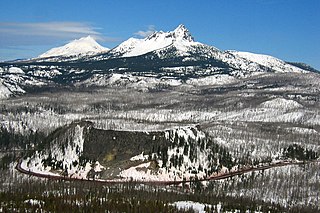
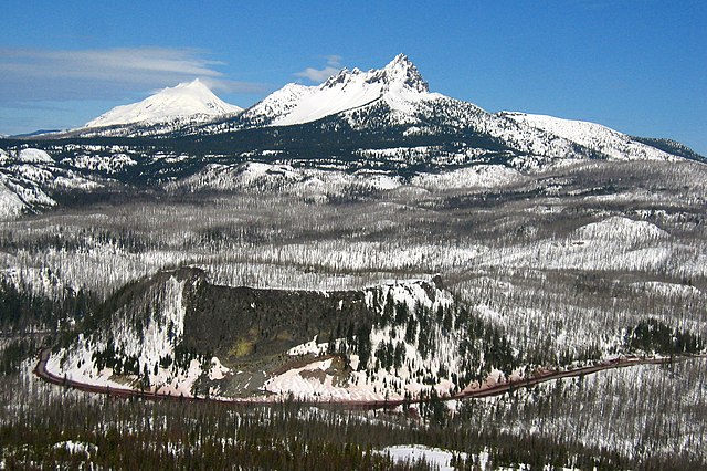
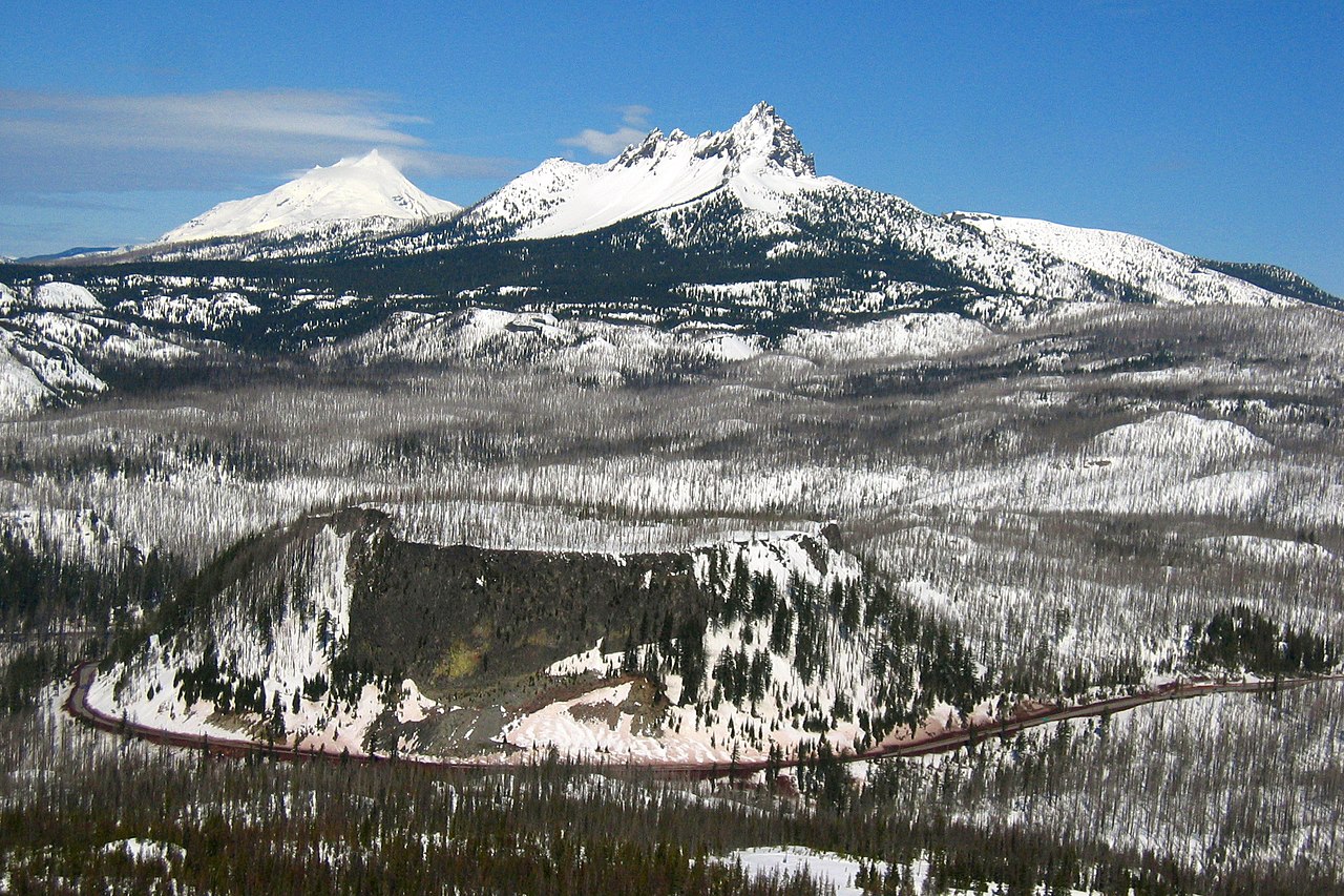
This is the majestic Santiam Pass, elevated at. 4817 ft above sea level in central Oregon Cascades. It is located about 18 mi (29 km) northwest of Sisters, between volcanic peaks of Three Fingered Jack to the north and Mount Washington to the south. U.S. Highway 20 connects eastern Oregon with the valley of the Santiam River on the west via Santiam Pass. One of the 19 or 20 lakes by the name of Lost Lake is located beside the highway just west of Santiam Pass. While the pass was known by native peoples, the first recorded crossing of the pass was in April 1859 by an expedition searching for a cattle trail over the Cascade Range from the Willamette Valley to Central Oregon. This expedition was led by Andrew Wiley, who reportedly climbed a tall tree on a mountain near Lost Prairie to help determine the route. Lost Prairie is located along Hackleman Creek between Fish Lake and Tombstone Prairie. Wiley later helped establish the Santiam Wagon Road. The prominent glaciated peak on the photo is the Three Fingered Jack, a Pleistocene volcano elevated 7,841 foot (2,390 meter), deeply glaciated and consists mainly of basaltic andesite lava. Mount Jefferson can also be seen from its left. The typical tuya volcano Hogg Rock, which is clearly visible from the photo below the Three Fingered Jack where US 20 Highway wraps in a nearly 180-degree curve below cliffs on the south and west sides, is only about 2 miles (3 km) north of Hayrick Butte, a somewhat larger tuya of similar age and composition. A tuya is a type of subglacial volcano, formed when lava erupts underneath an overlying glacier or ice sheet and then melts through to the surface and pools, producing the flat plateau on top with near-vertical walls along the ice-contact margin as the lava cools and hardens. Unlike most tuyas which have steep cliffs on all sides, Hogg Rock has a break in its cliffs on the east side, with a moderate slope which leads down to a small road and gravel pit. Santiam Pass was also the intended route over the Cascades for the Oregon Pacific Railroad, an early transcontinental railroad project led by Col. T. Egenton Hogg for whom Hogg Rock is named. Although the working line never extended east of Santiam Pass, the pass is today the eastern terminus of the Oregon Pacific Railroad Linear Historic District, which is listed on the US National Register of Historic Places. Taken from Hoodoo Ski Bowl summit. |
| 日期 | |
| 来源 | santiam pass |
| 作者 | Shaun Che from Oregon, US |
| 物体位置 | | 在以下服务上查看本图像和附近其他图像: OpenStreetMap |
|---|
许可协议
| 此张图片原发布于Flickr,在March 14, 2009由管理员或审查员File Upload Bot (Magnus Manske)检查后,确认检查时图片在Flickr的版权声明与维基共享资源的版权使用方针相符。 |
| 註解 | 該圖片含有註解:在維基媒體共享資源上查看註解 |
文件历史
点击某个日期/时间查看对应时刻的文件。
| 日期/时间 | 缩略图 | 大小 | 用户 | 备注 | |
|---|---|---|---|---|---|
| 当前 | 2009年3月14日 (六) 06:29 | | 2,272 × 1,514(1.86 MB) | File Upload Bot (Magnus Manske) | {{Information |Description= This is the majestic [http://en.wikipedia.org/wiki/Santiam_Pass Santiam Pass], elevated at. 4817 ft above sea level in central Oregon Cascades. It is located about 18 mi (29 km) northwest of Sisters, between volcanic peaks of |
文件用途
以下2个页面使用本文件:
全域文件用途
以下其他wiki使用此文件:
- en.wikipedia.org上的用途
- es.wikipedia.org上的用途
- fr.wikipedia.org上的用途
- id.wikipedia.org上的用途
- it.wikipedia.org上的用途
- pt.wikipedia.org上的用途
- uk.wikipedia.org上的用途
- www.wikidata.org上的用途