File:Schleswig-Holstein map.PNG
本预览的尺寸:389 × 600像素。 其他分辨率:156 × 240像素 | 311 × 480像素 | 763 × 1,176像素。
原始文件 (763 × 1,176像素,文件大小:131 KB,MIME类型:image/png)
| 描述 |
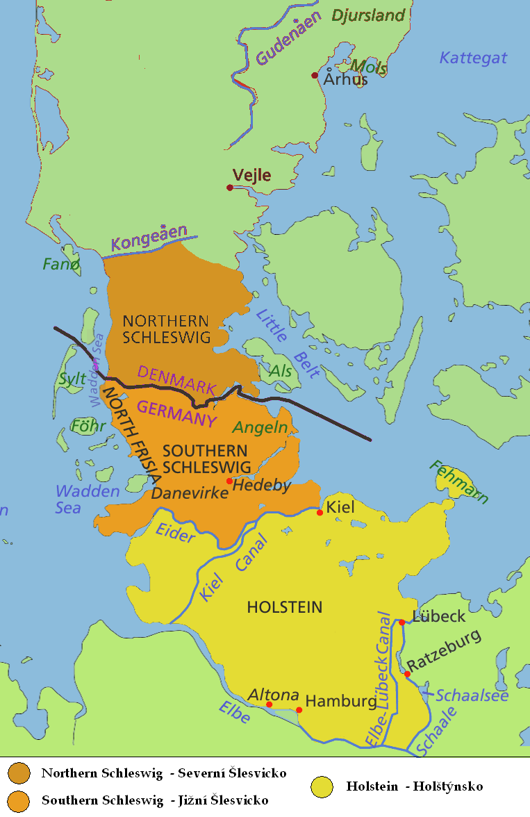
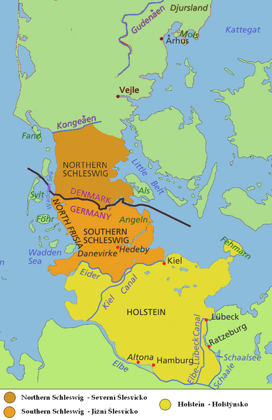
English: Map of Jutland Peninsula
Southern Jutland (Sønderjylland in Danish) or Northern Schleswig (Nordschleswig in German): Danish since 1920; part of the Duchy of Schleswig until 1864; German from 1864 until 1920
Southern Schleswig (German since 1864; part of the Duchy of Schleswig until 1864; formerly considered part of Southern Jutland)
Historical area of Holstein, sometimes considered part of Jutland Peninsula - south to the Elbe and the Elbe-Lübeck Canal
Deutsch: Karte der Halbinsel Jütland/Cimbrische Halbinsel
Nordschleswig, dänisch Sønderjylland (Südjütland): Herzogtum Schleswig bis 1864, Deutschland 1864 bis 1920, Dänemark seit 1920
Südschleswig (bis 1920 als Teil Südjütlands betrachtet): Herzogtum Schleswig bis 1864, Deutschland seit 1864
Historisches Gebiet von Holstein, manchmal als Teil der Halbinsel Jütland angesehen - südlich bis zur Elbe und dem Elbe-Lübeck-Kanal
Čeština: Mapa Jutského poloostrova
Jižní Jutsko, Severní Schleswig (Sønderjylland, Nordslesvig)
Jižní Schleswig
Historický Holstein |
| 日期 | (UTC) |
| 来源 | |
| 作者 |
|
| 这是一张修改过的图片,这意味着它已在原版本的基础上通过软件进行了编辑,改动内容:map only of Schleswig-Hostein region, in english and czech。其原始版本为:Jutland Peninsula map.PNG。修改者: Kolomaznik。
|
我,本作品著作权人,特此采用以下许可协议发表本作品:
- 您可以自由地:
- 共享 – 复制、发行并传播本作品
- 修改 – 改编作品
- 惟须遵守下列条件:
- 署名 – 您必须对作品进行署名,提供授权条款的链接,并说明是否对原始内容进行了更改。您可以用任何合理的方式来署名,但不得以任何方式表明许可人认可您或您的使用。
- 相同方式共享 – 如果您再混合、转换或者基于本作品进行创作,您必须以与原先许可协议相同或相兼容的许可协议分发您贡献的作品。
| 本文件采用知识共享署名-相同方式共享 3.0 未本地化版本许可协议授权。 | ||
| ||
| 本许可协议标签作为GFDL许可协议更新的组成部分被添加至本文件。 |

|
已授权您依据自由软件基金会发行的无固定段落及封面封底文字(Invariant Sections, Front-Cover Texts, and Back-Cover Texts)的GNU自由文件许可协议1.2版或任意后续版本的条款,复制、传播和/或修改本文件。该协议的副本请见“GNU Free Documentation License”。 |
您可以选择您需要的许可协议。
原始上传日志
This image is a derivative work of the following images:
- File:Jutland_Peninsula_map.PNG licensed with Cc-by-sa-2.5,2.0,1.0, Cc-by-sa-3.0-migrated, GFDL
- 2008-04-23T10:22:18Z PhJ 964x1741 (145790 Bytes) {{Information |Description= |Source= |Date= |Author= |Permission= |other_versions= }}
- 2006-05-04T07:46:11Z Roke 964x1741 (120421 Bytes) schaale schaalsee
- 2006-04-29T03:27:54Z Roke 964x1741 (118906 Bytes) Altona position
- 2006-04-29T03:21:29Z Roke 964x1741 (118899 Bytes) wadden sea, nordstrand border, extend yellow to Schalle and Ratzeburg, +Altona, +Helgoland
- 2006-04-27T00:20:44Z Roke 964x1741 (115442 Bytes) nordstrand
- 2006-04-27T00:15:11Z Roke 964x1741 (115380 Bytes) same colour from border to Eider river
- 2006-04-26T01:22:06Z Valentinian 964x1741 (137475 Bytes) Fixed Nordstrand
- 2006-04-25T12:45:35Z Roke 964x1741 (116408 Bytes) moved dannevirke north
- 2006-04-25T05:30:35Z Roke 964x1741 (116169 Bytes) deleted a layer i shouldnt have
- 2006-04-25T05:26:17Z Roke 964x1741 (114293 Bytes) minor fix of eider, kiel canal
- 2006-04-25T05:02:03Z Roke 964x1741 (116502 Bytes) eider, wadden sea, hedeby
- 2006-04-17T06:17:25Z Roke 964x1741 (116712 Bytes) Map of Jutland Peninsula [[Category:Denmark]]
Uploaded with derivativeFX
文件历史
点击某个日期/时间查看对应时刻的文件。
| 日期/时间 | 缩略图 | 大小 | 用户 | 备注 | |
|---|---|---|---|---|---|
| 当前 | 2009年8月2日 (日) 16:17 | | 763 × 1,176(131 KB) | Kolomaznik | {{Information |Description= |Source=*File:Jutland_Peninsula_map.PNG |Date=2009-08-02 16:15 (UTC) |Author=*File:Jutland_Peninsula_map.PNG: Roke *derivative work: ~~~ |Permission=see below |other_versions= }} {{RetouchedPicture|map only of Sch |
文件用途
以下页面使用本文件:
全域文件用途
以下其他wiki使用此文件:
- ca.wikipedia.org上的用途
- cs.wikipedia.org上的用途
- fi.wikipedia.org上的用途
- fr.wiktionary.org上的用途
- ja.wikipedia.org上的用途