File:SiegeAlesia.png
本预览的尺寸:693 × 599像素。 其他分辨率:278 × 240像素 | 555 × 480像素 | 977 × 845像素。
原始文件 (977 × 845像素,文件大小:46 KB,MIME类型:image/png)

|
此map图片可使用矢量图形重新创建为SVG文件。这具有很多好处;更多信息请参见共享资源:待清理媒体。如果存在此图片的SVG格式,请将其上传,然后将此模板替换为
{{vector version available|新图片名称}}。
建议您将SVG命名为“SiegeAlesia.svg”,这样在使用Vector version available(或Vva)模板时就不需要填写新图片名称参数。 |
摘要
| 描述 |
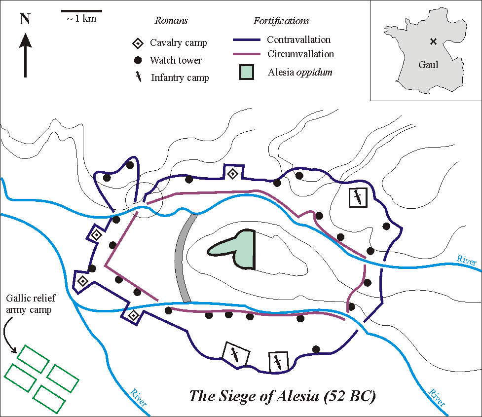
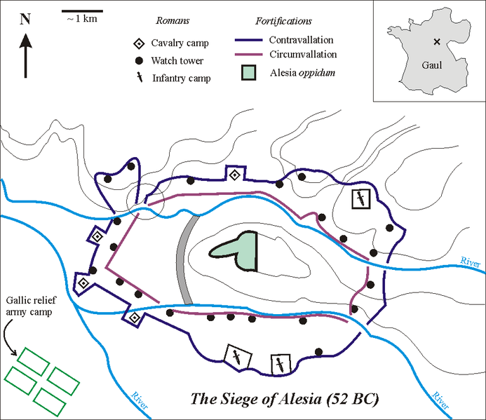
English: Sketch of the Battle of Alesia, drawn by Muriel Gottrop in December 2004. Inbox: cross shows location of Alesia in Gaul (modern France). The open circle shows the weakness in the contravallation line
Deutsch: Skizze der Schlacht um Alesia von Muriel Gottrop, Dezember 2004. Der Kartenausschnitt zeigt die Lage von Alesia in Gallien (heute Frankreich). Der offene Kreis zeigt die Schwachstelle in der Contravallation
Español: Las fortificaciones construidas por César en Alesia de acuerdo a la hipótesis de localización en Alise-Sainte-Reine En el mapa de la esquina la cruz muestra la localización de Alesia en la Galia (hoy Francia). En el esquema, el círculo muestra el punto débil en la circunvalación |
| 来源 | |
| 作者 | 英语维基百科的Muriel Gottrop |
| 其他版本 |
[]
|


本文件采用知识共享署名-相同方式共享 1.0 通用许可协议授权。
- 您可以自由地:
- 共享 – 复制、发行并传播本作品
- 修改 – 改编作品
- 惟须遵守下列条件:
- 署名 – 您必须对作品进行署名,提供授权条款的链接,并说明是否对原始内容进行了更改。您可以用任何合理的方式来署名,但不得以任何方式表明许可人认可您或您的使用。
- 相同方式共享 – If you alter, transform, or build upon this work, you must distribute the resulting work under the same license as the original.
文件历史
点击某个日期/时间查看对应时刻的文件。
| 日期/时间 | 缩略图 | 大小 | 用户 | 备注 | |
|---|---|---|---|---|---|
| 当前 | 2004年12月2日 (四) 12:03 | | 977 × 845(46 KB) | Muriel Gottrop~commonswiki | Sketch of the Battle of Alesia, drawn by Muriel Gottrop in December 2004. {{GFDL}} |
文件用途
以下页面使用本文件:
全域文件用途
以下其他wiki使用此文件:
- ar.wikipedia.org上的用途
- azb.wikipedia.org上的用途
- az.wikipedia.org上的用途
- bg.wikipedia.org上的用途
- bo.wikipedia.org上的用途
- ca.wikipedia.org上的用途
- cs.wikipedia.org上的用途
- cy.wikipedia.org上的用途
- en.wikipedia.org上的用途
- es.wikipedia.org上的用途
- fa.wikipedia.org上的用途
- fi.wikipedia.org上的用途
- he.wikipedia.org上的用途
- hr.wikipedia.org上的用途
- hu.wikipedia.org上的用途
- hy.wikipedia.org上的用途
- id.wikipedia.org上的用途
- it.wikipedia.org上的用途
- ja.wikipedia.org上的用途
- ko.wikipedia.org上的用途
- ms.wikipedia.org上的用途
- nl.wikipedia.org上的用途
- no.wikipedia.org上的用途
- pl.wikipedia.org上的用途
- ro.wikipedia.org上的用途
- sl.wikipedia.org上的用途
- sr.wikipedia.org上的用途
- uk.wikipedia.org上的用途
- www.wikidata.org上的用途