File:SierraEscarpmentCA.jpg
本预览的尺寸:799 × 203像素。 其他分辨率:320 × 81像素 | 640 × 163像素。
原始文件 (2,359 × 600像素,文件大小:424 KB,MIME类型:image/jpeg)
摘要
| 描述 |
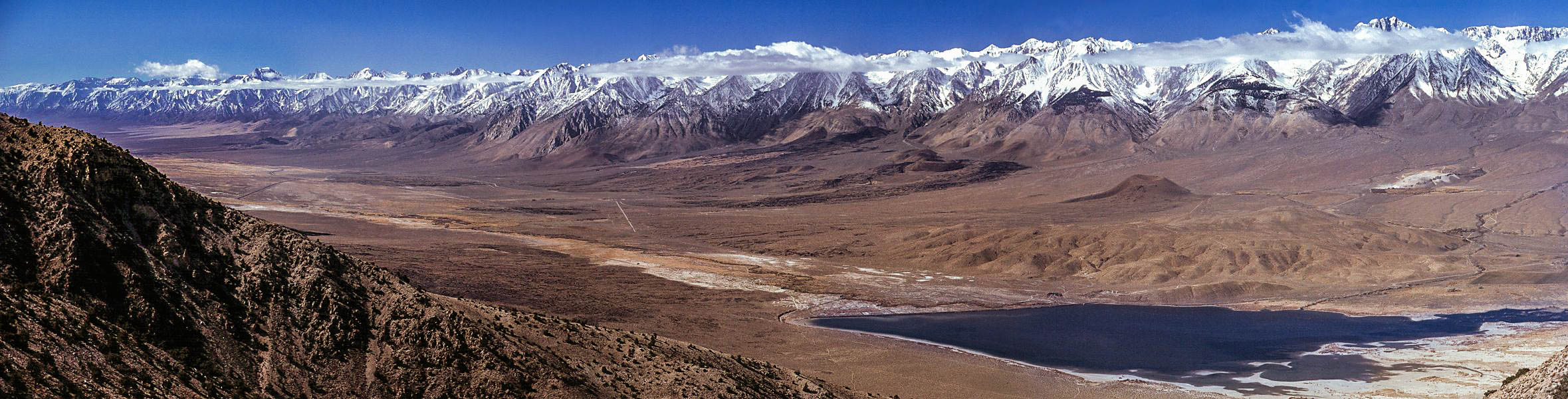
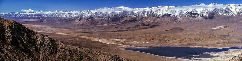
English: Owens Valley, eastern California, and the eastern escarpment of the Sierra Nevada mountain range. The view is looking southwest from the Inyo Mountains near Harkless Flat. Tinemaha Reservoir is visible in the near distance. There is an old cabin and an old mining trail owned and still claimed here at Harkless Flat. |
| 日期 | 2006年6月2日 (原始上传日期) |
| 来源 | 自己的作品 |
| 作者 | G. Thomas (留言 · 贡献) |
| 其他版本 | 此文件衍生的作品: Tinemaha Reservoir.jpg |
| 相机位置 | | 在以下服务上查看本图像和附近其他图像: OpenStreetMap |
|---|
许可协议
| 本作品已被作者英语维基百科的G. Thomas释出到公有领域。这适用于全世界。 在一些国家这可能不合法;如果是这样的话,那么: G. Thomas无条件地授予任何人以任何目的使用本作品的权利,除非这些条件是法律规定所必需的。 |
原始上传日志
原始描述頁面位於這裡。下列使用者名稱均來自en.wikipedia。
- 2006-06-02 21:08 G. Thomas 2359×600× (317148 bytes) Owens Valley, California, and the eastern escarpment of the Sierra Nevada mountains, looking southwest from the Inyo Mountains near Harkless Flat. Tinemaha Reservoir is visible in the near distance.
| 註解 | 該圖片含有註解:在維基媒體共享資源上查看註解 |
文件历史
点击某个日期/时间查看对应时刻的文件。
| 日期/时间 | 缩略图 | 大小 | 用户 | 备注 | |
|---|---|---|---|---|---|
| 当前 | 2014年12月24日 (三) 02:54 | 2,359 × 600(424 KB) | WPMember | color balance changes, resolving haloing issue | |
| 2014年12月24日 (三) 02:45 | 2,359 × 600(369 KB) | WPMember | Sharpen and increase saturation to better levels for screen display | ||
| 2006年8月7日 (一) 08:59 | 2,359 × 600(310 KB) | Urban~commonswiki | From : http://upload.wikimedia.org/wikipedia/en/7/7b/SierraEscarpmentCA.jpg == Summary == Owens Valley, California, and the eastern escarpment of the Sierra Nevada mountains, looking southwest from the Inyo Mountains near Harkless Flat. Tinemaha Reservo |
文件用途
全域文件用途
以下其他wiki使用此文件:
- ar.wikipedia.org上的用途
- az.wikipedia.org上的用途
- ba.wikipedia.org上的用途
- de.wikipedia.org上的用途
- el.wikipedia.org上的用途
- en.wikipedia.org上的用途
- Sierra Nevada
- Inyo County, California
- Escarpment
- Owens Valley
- Owens River
- Wikipedia:Featured picture candidates/January-2007
- Wikipedia:Featured picture candidates/Sierra Escarpment
- Portal:California/Selected panorama/8
- Portal:California/Selected panorama/Archives
- Big Pine volcanic field
- Nevadaplano
- User:Dronebogus/Basement
- eo.wikipedia.org上的用途
- es.wikipedia.org上的用途
- fa.wikipedia.org上的用途
- fr.wikipedia.org上的用途
- he.wikipedia.org上的用途
- id.wikipedia.org上的用途
- it.wikipedia.org上的用途
- ja.wikipedia.org上的用途
- la.wikipedia.org上的用途
- ml.wikipedia.org上的用途
- pnb.wikipedia.org上的用途
- pt.wikipedia.org上的用途
- ru.wikipedia.org上的用途
- sr.wikipedia.org上的用途
- uk.wikipedia.org上的用途
- uz.wikipedia.org上的用途
- www.wikidata.org上的用途