File:Tad Fane Waterfall.JPG
此为最大尺寸。
Tad_Fane_Waterfall.JPG (550 × 413像素,文件大小:128 KB,MIME类型:image/jpeg)
摘要
| 描述 |
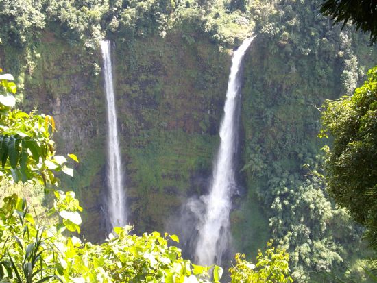
English: Tad Fan waterfall is situated in the Bolaven Plateau. The water drops about 120m.
ລາວ: ຕາດຟານ |
| 日期 | |
| 来源 | 自己的作品 |
| 作者 | Sebomann |
| 相机位置 | | 在以下服务上查看本图像和附近其他图像: OpenStreetMap |
|---|
许可协议
| 我,本作品著作权人,释出本作品至公有领域。这适用于全世界。 在一些国家这可能不合法;如果是这样的话,那么: 我无条件地授予任何人以任何目的使用本作品的权利,除非这些条件是法律规定所必需的。 |
文件历史
点击某个日期/时间查看对应时刻的文件。
| 日期/时间 | 缩略图 | 大小 | 用户 | 备注 | |
|---|---|---|---|---|---|
| 当前 | 2008年7月19日 (六) 21:11 | | 550 × 413(128 KB) | Sebomann | {{Information |Description={{en|1=Tad Fane waterfall is situated in the Bolaven Plateau. The water drops about 120m.}} |Source=Own work by uploader |Author=Sebomann |Date=10-31-07 |Permission= |other_versions= }} {{ImageUpload|full}} |
文件用途
以下4个页面使用本文件:
全域文件用途
以下其他wiki使用此文件:
- de.wikipedia.org上的用途
- de.wikivoyage.org上的用途
- en.wikipedia.org上的用途
- en.wikivoyage.org上的用途
- eo.wikipedia.org上的用途
- es.wikipedia.org上的用途
- fr.wikivoyage.org上的用途
- id.wikipedia.org上的用途
- it.wikipedia.org上的用途
- it.wikivoyage.org上的用途
- ja.wikipedia.org上的用途
- km.wikipedia.org上的用途
- ko.wikipedia.org上的用途
- lld.wikipedia.org上的用途
- mt.wikipedia.org上的用途
- pl.wikipedia.org上的用途
- pt.wikipedia.org上的用途
- ru.wikipedia.org上的用途
- th.wikipedia.org上的用途
- vi.wikipedia.org上的用途
- www.wikidata.org上的用途
- zh.wikivoyage.org上的用途