File:Tashkent City districts.png

本预览的尺寸:764 × 600像素。 其他分辨率:306 × 240像素 | 611 × 480像素 | 978 × 768像素 | 1,280 × 1,005像素。
原始文件 (1,280 × 1,005像素,文件大小:120 KB,MIME类型:image/png)
摘要
| 描述 |
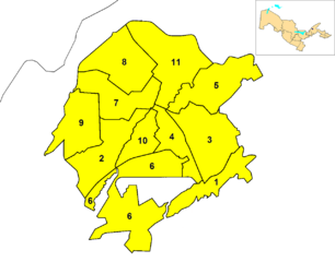
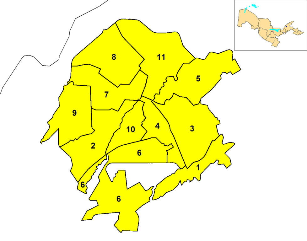
English: Map of the districts (tuman) of the province (viloyat) of Tashkent City in Uzbekistan. A map of Uzbekistan, highlighting Tashkent (blue dot), is shown in the upper right corner. |
| 日期 | |
| 来源 | 自己的作品 |
| 作者 | Rarelibra |
许可协议
| 我,本作品著作权人,释出本作品至公有领域。这适用于全世界。 在一些国家这可能不合法;如果是这样的话,那么: 我无条件地授予任何人以任何目的使用本作品的权利,除非这些条件是法律规定所必需的。 |
文件历史
点击某个日期/时间查看对应时刻的文件。
| 日期/时间 | 缩略图 | 大小 | 用户 | 备注 | |
|---|---|---|---|---|---|
| 当前 | 2014年10月10日 (五) 05:23 | | 1,280 × 1,005(120 KB) | Carpodacus | Delete fragment of incorrect border in the old version |
| 2014年10月9日 (四) 13:08 |  | 1,280 × 1,005(120 KB) | Carpodacus | Correct borders | |
| 2011年12月23日 (五) 15:19 |  | 1,576 × 1,237(66 KB) | DerBorg | new version (highlighting quarter map, removed white external frame) | |
| 2008年10月20日 (一) 17:59 |  | 2,112 × 1,632(42 KB) | Rarelibra | {{Information |Description={{en|1=Map of the districts (tuman) of the province (viloyat) of Tashkent City in Uzbekistan.}} |Source=Own work by uploader |Author=Rarelibra |Date=10/20/2008 |Permission= |other_versions= }} <!--{{ImageUplo |
文件用途
以下页面使用本文件:
全域文件用途
以下其他wiki使用此文件:
- ar.wikipedia.org上的用途
- ast.wikipedia.org上的用途
- azb.wikipedia.org上的用途
- de.wikipedia.org上的用途
- en.wikipedia.org上的用途
- es.wikipedia.org上的用途
- fa.wikipedia.org上的用途
- fr.wikipedia.org上的用途
- ja.wikipedia.org上的用途
- kk.wikipedia.org上的用途
- ko.wikipedia.org上的用途
- mn.wikipedia.org上的用途
- pnb.wikipedia.org上的用途
- ru.wikipedia.org上的用途
- ug.wikipedia.org上的用途
- ur.wikipedia.org上的用途
- uz.wikipedia.org上的用途
查看本文件的更多全域用途。