File:The Big Muddy, Western Edition (6987590721).jpg

原始文件 (5,559 × 3,706像素,文件大小:5.91 MB,MIME类型:image/jpeg)
.jpg?uselang=zh)
.jpg?uselang=zh)
.jpg?action=history&uselang=zh)
.jpg)
摘要
| 描述 |
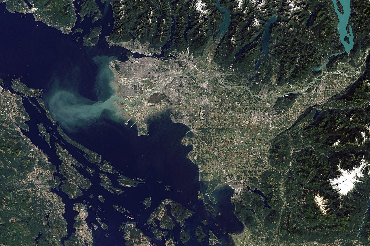
Arising from headwaters around Mount Robson in the Rocky Mountains, the Fraser River starts as a fast-moving stream. The river angles northward around the Columbia Mountains, picking up so much sediment that it appears brown by the time it reaches Quesnel. Near the coast, the river flows over flatter terrain, so it slows down and spreads out. On the final leg of its journey, the Fraser travels along the southern fringe of Vancouver. The Thematic Mapper on the Landsat 5 satellite captured this image of Vancouver on September 7, 2011. Flowing through braided channels, the Fraser River meanders toward the sea, emptying through multiple outlets. The river’s abundant sediment forms a distinct plume west of Vancouver, extending across the Strait of Georgia to the eastern shore of Valdes Island. In fact, the Fraser River carries an estimated 20 million metric tons of sediment to the Pacific Ocean each year. Some of it drops out of the water before reaching the ocean, and this steady delivery has contributed to the landscape of Vancouver. The muddy surface of the river often hides the complex, turbulent activity below. The mouth of the Fraser River is an estuary—a place where freshwater from rivers mixes with salt water from the ocean. But this estuary differs from some others in North America. In the San Francisco Bay, the Chesapeake Bay, and the mouth of the Hudson River, the mixing of salt and fresh water extends over miles. Near Vancouver, the mixing occurs along an abrupt front spanning just tens of meters. Although the swirling water and thick sediment can confuse salmon, the mixing also expels stagnant water and pollution and draws in oxygen. A salmon-rich river draining into a seafood-rich ocean likely played a role in human settlement along the Fraser. Artifacts in this region suggest that human occupation may have started as long as 16,000 years ago. Unlike many other rivers, the Fraser has not been dammed. But it faces an indirect threat from pine beetle infestation; the subsequent removal of trees may warm the river water, making it inhospitable to the fish. NASA Earth Observatory image created by Robert Simmon and Jesse Allen, using Landsat data provided by the United States Geological Survey. Caption by Michon Scott. Instrument: Landsat 5 - TM Credit: NASA Earth Observatory NASA Goddard Space Flight Center enables NASA’s mission through four scientific endeavors: Earth Science, Heliophysics, Solar System Exploration, and Astrophysics. Goddard plays a leading role in NASA’s accomplishments by contributing compelling scientific knowledge to advance the Agency’s mission. Follow us on Twitter Like us on Facebook Find us on Instagram |
| 日期 | |
| 来源 | The Big Muddy, Western Edition |
| 作者 | NASA Goddard Space Flight Center from Greenbelt, MD, USA |
| 其他版本 |
 |
| 相机位置 | | 在以下服务上查看本图像和附近其他图像: OpenStreetMap |
|---|
.jpg¶ms=049.252568_N_-123.213501_E_globe:Earth_type:camera_source:Flickr_&language=zh)
许可协议
| 这幅图片原始出处为Flickr的https://flickr.com/photos/24662369@N07/6987590721 ,作者为NASA Goddard Photo and Video 。经机器人FlickreviewR在2016年9月17日审查后确定为采用cc-by-2.0的协议授权使用。 |
| 本文件完全由NASA创作,在美国属于公有领域。根据NASA的版权方针,NASA的材料除非另有声明否则不受版权保护。(参见Template:PD-USGov/zh、NASA版权方针页面或JPL图片使用方针。) | ||
 |
警告:
|
文件历史
点击某个日期/时间查看对应时刻的文件。
| 日期/时间 | 缩略图 | 大小 | 用户 | 备注 | |
|---|---|---|---|---|---|
| 当前 | 2016年9月17日 (六) 21:48 | | 5,559 × 3,706(5.91 MB) | Vanished Account Byeznhpyxeuztibuo | Transferred from Flickr via Flickr2Commons |
文件用途
以下页面使用本文件:
全域文件用途
以下其他wiki使用此文件:
- en.wikipedia.org上的用途
- es.wikipedia.org上的用途
- fr.wikipedia.org上的用途
.jpg)