File:Tropical Cyclone Emma 2006.jpg

本预览的尺寸:469 × 599像素。 其他分辨率:188 × 240像素 | 376 × 480像素 | 601 × 768像素 | 801 × 1,024像素 | 1,603 × 2,048像素 | 7,201 × 9,201像素。
原始文件 (7,201 × 9,201像素,文件大小:8.9 MB,MIME类型:image/jpeg)
| 警告 | 部分浏览器在浏览此图片的完整大小时可能会遇到困难:该图片中有数量巨大的像素点,可能无法完全载入或者导致您的浏览器停止响应。 |
|---|
摘要
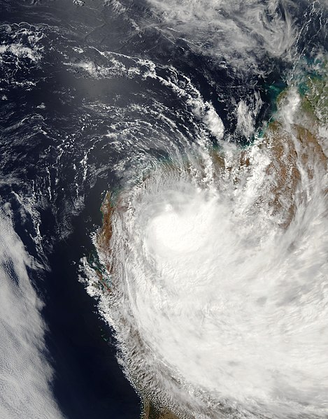
| 描述 | Tropical Cyclone Emma formed as a low-intensity storm system and built to cyclone strength only briefly. But Emma’s brief cyclone status belied its size and rainfall. The Moderate Resolution Imaging Spectrometer (MODIS) instrument on the Aqua observed the storm system as it was losing strength, and hence its tropical cyclone status, on February 28, 2006, at 5:55 UTC (1:55 p.m. local time). At this time, the cyclone had peak winds of roughly 55 kilometers per hour (35 miles per hour). As the image shows, the storm system covered an enormous area, extending over almost the entire extent of Western Australia. With it came heavy rain and substantial flooding to the Pilbara Region, the northwestern corner of Western Australia, where the storm system came ashore. | |||||
| 日期 | ||||||
| 来源 | http://earthobservatory.nasa.gov/NaturalHazards/natural_hazards_v2.php3?img_id=13385 | |||||
| 作者 | NASA image created by Jesse Allen, Earth Observatory, using data obtained from the Goddard Earth Sciences DAAC. | |||||
| 授权 (二次使用本文件) |
|

文件历史
点击某个日期/时间查看对应时刻的文件。
| 日期/时间 | 缩略图 | 大小 | 用户 | 备注 | |
|---|---|---|---|---|---|
| 当前 | 2019年1月11日 (五) 17:12 | | 7,201 × 9,201(8.9 MB) | FleurDeOdile | remove missing data |
| 2006年8月29日 (二) 14:40 |  | 6,476 × 8,635(5.21 MB) | Good kitty | == Summary == {{Information |Description=Tropical Cyclone Emma formed as a low-intensity storm system and built to cyclone strength only briefly. But Emma’s brief cyclone status belied its size and rainfall. The Moderate Resolution Imaging Spectrometer |
文件用途
以下页面使用本文件:
全域文件用途
以下其他wiki使用此文件:
- en.wikipedia.org上的用途
- pt.wikipedia.org上的用途