File:Ukraine under russian occupation grey.svg

此SVG文件的PNG预览的大小:800 × 538像素。 其他分辨率:320 × 215像素 | 640 × 430像素 | 1,024 × 688像素 | 1,280 × 860像素 | 2,560 × 1,720像素 | 3,780 × 2,540像素。
原始文件 (SVG文件,尺寸为3,780 × 2,540像素,文件大小:1.8 MB)
摘要
| 描述 |
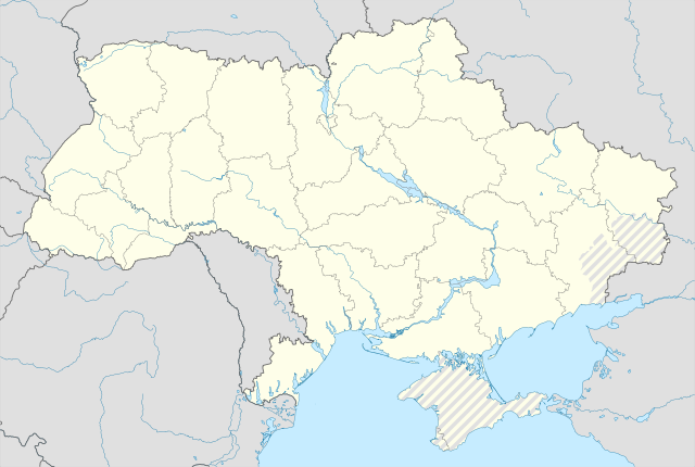
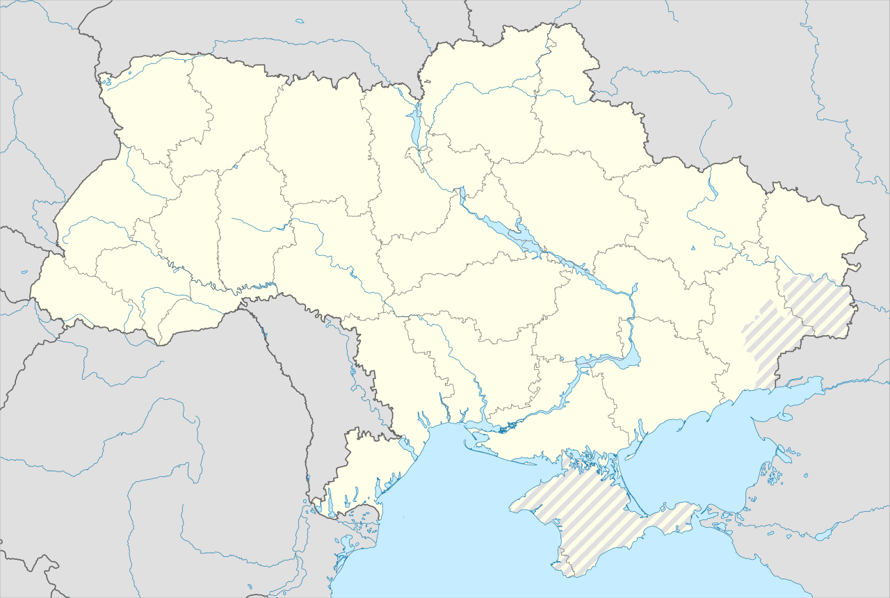
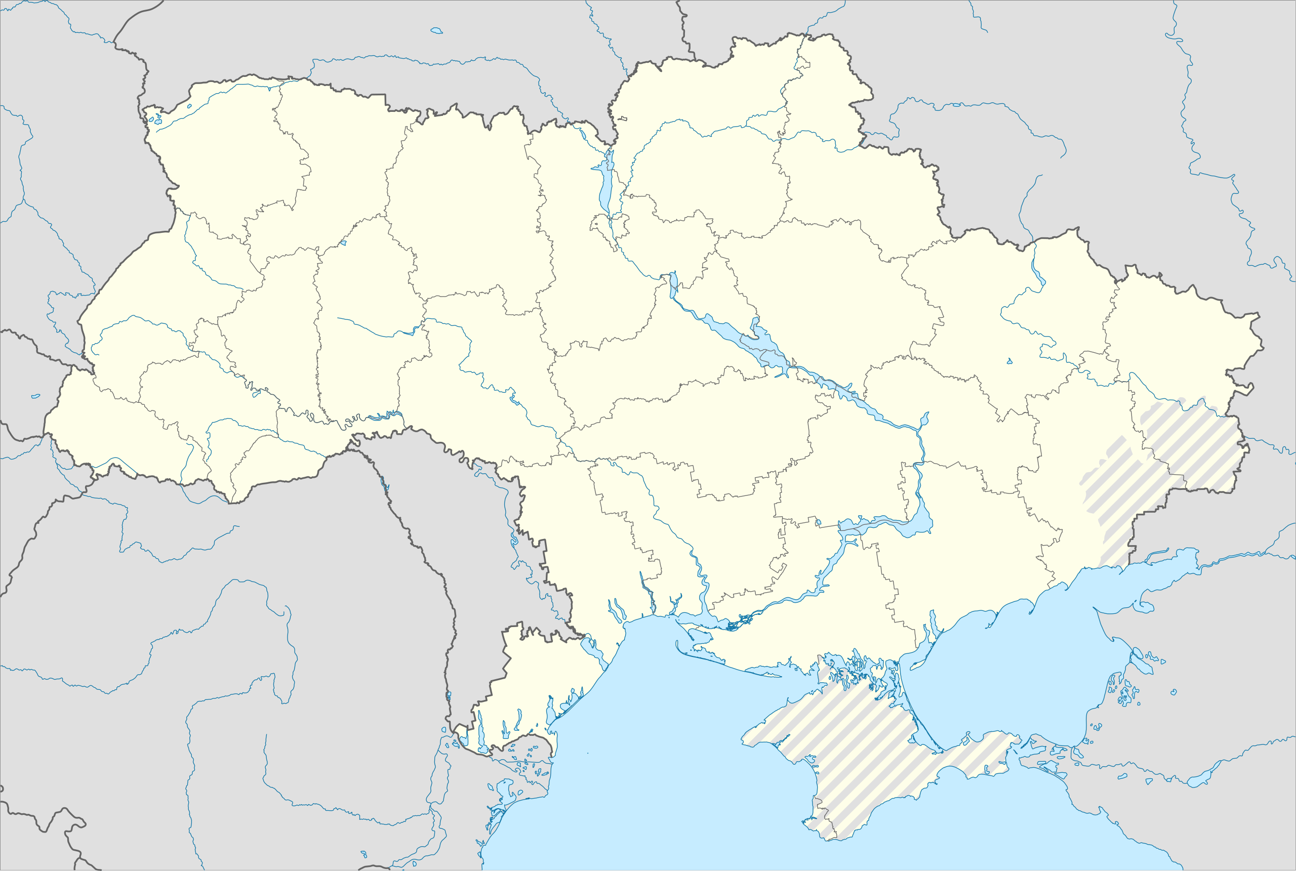
English: Location map of Ukraine under Russian occupation.
Українська: Карта України з зонами російської окупації. |
| 日期 | |
| 来源 |
个人作品,使用: Ukraine adm location map improved.svg, according to
|
| 作者 | Yakiv Gluck |
| 其他版本 |
|
| SVG开发 | 本矢量图使用Adobe Illustrator创作。 |


许可协议
我,本作品著作权人,特此采用以下许可协议发表本作品:
本文件采用知识共享署名-相同方式共享 4.0 国际许可协议授权。
- 您可以自由地:
- 共享 – 复制、发行并传播本作品
- 修改 – 改编作品
- 惟须遵守下列条件:
- 署名 – 您必须对作品进行署名,提供授权条款的链接,并说明是否对原始内容进行了更改。您可以用任何合理的方式来署名,但不得以任何方式表明许可人认可您或您的使用。
- 相同方式共享 – 如果您再混合、转换或者基于本作品进行创作,您必须以与原先许可协议相同或相兼容的许可协议分发您贡献的作品。
文件历史
点击某个日期/时间查看对应时刻的文件。
| 日期/时间 | 缩略图 | 大小 | 用户 | 备注 | |
|---|---|---|---|---|---|
| 当前 | 2023年6月19日 (一) 06:53 | | 3,780 × 2,540(1.8 MB) | Physeters | Reverted to version as of 02:11, 12 May 2023 (UTC) revert removed my detail improvements in the Dnieper delta and is no longer accurate |
| 2023年6月18日 (日) 21:48 |  | 3,780 × 2,540(1.54 MB) | Yeagvr | Reverted to version as of 17:23, 3 October 2022 (UTC) | |
| 2023年5月12日 (五) 02:11 |  | 3,780 × 2,540(1.8 MB) | Physeters | add improved tracing of the Dnieper Delta | |
| 2022年10月4日 (二) 01:30 |  | 3,780 × 2,540(1.36 MB) | Tol | Reverted to version as of 17:17, 3 March 2018 (UTC): this substantially changes a file that was not expected to be updated, this file is intentionally different from File:Ukraine under russian occupation.svg | |
| 2022年10月3日 (一) 17:23 |  | 3,780 × 2,540(1.54 MB) | Janitoalevic | Updated. | |
| 2018年3月3日 (六) 17:17 |  | 3,780 × 2,540(1.36 MB) | Yakiv Gluck | improved using new adm loc map | |
| 2018年1月27日 (六) 01:36 |  | 1,546 × 1,038(457 KB) | Yakiv Gluck | {{Information |Description ={{en|Location map of Ukraine under russian occupation.}} {{uk|Карта України з зонами російської окупації.}} |Source =own work, using [[:F... |
文件用途
没有页面链接到本图像。
全域文件用途
以下其他wiki使用此文件:
- bcl.wikipedia.org上的用途
- bn.wikipedia.org上的用途
- en.wikipedia.org上的用途
- Chernobyl
- Geography of Ukraine
- Poltava
- Kerch
- Sevastopol
- Tarashcha
- Yalta
- Nestor Makhno
- Sverdlovsk, Ukraine
- Chernivtsi
- Kaniv
- Halych
- Pripyat
- Lutsk
- Drohobych
- Kovel
- Ivano-Frankivsk
- Kalush, Ukraine
- Volodymyr (city)
- Kortelisy
- Starobilsk
- Uzhhorod
- Chernihiv
- Sumy
- Staryi Ostropil
- Kyiv
- Kosivka, Odesa Oblast
- Kosiv
- Shpola
- Mukachevo
- Simferopol
- Irpin
- Khmelnytskyi
- Fastiv
- Boltysh crater
查看本文件的更多全域用途。