File:Via Appia map.jpg

本预览的尺寸:800 × 433像素。 其他分辨率:320 × 173像素 | 640 × 346像素 | 1,280 × 692像素。
原始文件 (1,280 × 692像素,文件大小:599 KB,MIME类型:image/jpeg)

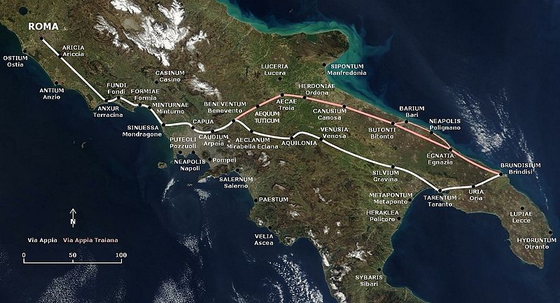
English: Map of the Appian Way and the later and shorter Via Appia Traiana.
Deutsch: Karte der Via Appia und der Via Appia Traiana.
摘要
This map is based on the following picture: Image:Satellite image of Italy in March 2003.jpg
许可协议
| 我,本作品著作权人,释出本作品至公有领域。这适用于全世界。 在一些国家这可能不合法;如果是这样的话,那么: 我无条件地授予任何人以任何目的使用本作品的权利,除非这些条件是法律规定所必需的。 |
| 本文件完全由NASA创作,在美国属于公有领域。根据NASA的版权方针,NASA的材料除非另有声明否则不受版权保护。(参见Template:PD-USGov/zh、NASA版权方针页面或JPL图片使用方针。) | ||
 |
警告:
|
文件历史
点击某个日期/时间查看对应时刻的文件。
| 日期/时间 | 缩略图 | 大小 | 用户 | 备注 | |
|---|---|---|---|---|---|
| 当前 | 2009年11月9日 (一) 17:19 | | 1,280 × 692(599 KB) | AlMare | Mondragone |
| 2009年7月27日 (一) 16:22 |  | 1,280 × 692(602 KB) | AlMare | +Aequum Tuticum | |
| 2009年2月14日 (六) 18:02 |  | 1,280 × 692(538 KB) | AlMare | Reverted to version as of 17:31, 13 July 2006 | |
| 2008年12月1日 (一) 21:03 |  | 1,280 × 692(603 KB) | AlMare | +Sessa Aurunca | |
| 2006年7月13日 (四) 17:31 |  | 1,280 × 692(538 KB) | AlMare | == Summary == This map is based on the following picture: Image:Satellite image of Italy in March 2003.jpg == Licensing == {{PD-self}} | |
| 2006年7月13日 (四) 17:26 |  | 1,000 × 433(357 KB) | AlMare | This map is based on the following picture: Image:Satellite image of Italy in March 2003.jpg) |
&action=edit&redlink=1)
文件用途
以下页面使用本文件:
全域文件用途
以下其他wiki使用此文件:
- af.wikipedia.org上的用途
- ar.wikipedia.org上的用途
- azb.wikipedia.org上的用途
- be.wikipedia.org上的用途
- bg.wikipedia.org上的用途
- bn.wikipedia.org上的用途
- ca.wikipedia.org上的用途
- cs.wikipedia.org上的用途
- de.wikipedia.org上的用途
- el.wikipedia.org上的用途
- en.wikipedia.org上的用途
- en.wikivoyage.org上的用途
- eo.wikipedia.org上的用途
- es.wikipedia.org上的用途
- et.wikipedia.org上的用途
- fr.wikipedia.org上的用途
- he.wikipedia.org上的用途
- hr.wikipedia.org上的用途
- hu.wikipedia.org上的用途
- id.wikipedia.org上的用途
- it.wikipedia.org上的用途
查看本文件的更多全域用途。