File:WalesRef97YesVote.png

本预览的尺寸:533 × 599像素。 其他分辨率:213 × 240像素 | 427 × 480像素 | 882 × 992像素。
原始文件 (882 × 992像素,文件大小:25 KB,MIME类型:image/png)
摘要
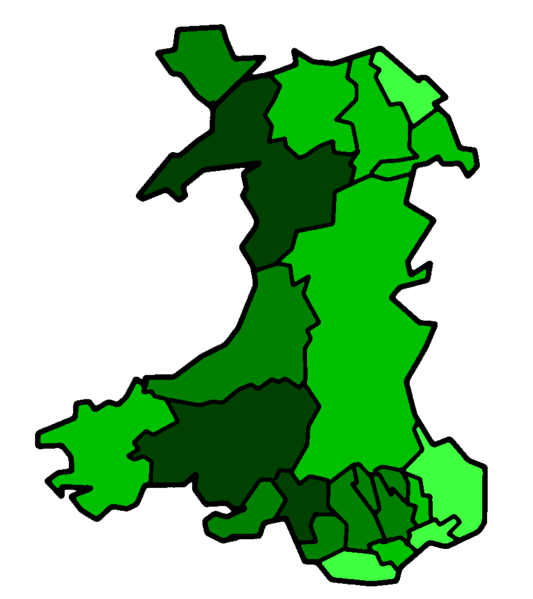
This is a map of the result of the 1997 referendum on devolution held in Wales on 18 Sept 1997. This map shows all 22 unitary authorities colour-coded by their percentage of votes for the Welsh Assembly (the darker colour shows a strong vote for the Assembly, while the lighter colours shows a weak vote for the Assembly). The map has been made from Morwen's blank map of Wales. As the original map was GFDL, this map is GFDL as well. The figures used to compile the map are from the BBC.
Key
30.1-39.9% of vote
40.1-49.9% of vote
50.1-59.9% of vote
60.1%+ of vote
许可协议

|
已授权您依据自由软件基金会发行的无固定段落及封面封底文字(Invariant Sections, Front-Cover Texts, and Back-Cover Texts)的GNU自由文件许可协议1.2版或任意后续版本的条款,复制、传播和/或修改本文件。该协议的副本请见“GNU Free Documentation License”。 |
| 本文件采用知识共享署名-相同方式共享 3.0 未本地化版本许可协议授权。 | ||
| ||
| 本许可协议标签作为GFDL许可协议更新的组成部分被添加至本文件。 |
文件历史
点击某个日期/时间查看对应时刻的文件。
| 日期/时间 | 缩略图 | 大小 | 用户 | 备注 | |
|---|---|---|---|---|---|
| 当前 | 2006年8月16日 (三) 03:21 | | 882 × 992(25 KB) | Hoshie | ==Summary== This is a map of the result of the 1997 referendum on devolution held in Wales on 18 Sept 1997. This map shows all 22 unitary authorities colour-coded by their percentage of votes for the Welsh Assembly (the darker colour shows a strong vote |
文件用途
没有页面链接到本图像。