File:World 1914 empires colonies territory.PNG

本预览的尺寸:800 × 330像素。 其他分辨率:320 × 132像素 | 640 × 264像素 | 1,522 × 628像素。
原始文件 (1,522 × 628像素,文件大小:45 KB,MIME类型:image/png)

|
此map图片可使用矢量图形重新创建为SVG文件。这具有很多好处;更多信息请参见共享资源:待清理媒体。如果存在此图片的SVG格式,请将其上传,然后将此模板替换为
{{vector version available|新图片名称}}。
建议您将SVG命名为“World 1914 empires colonies territory.svg”,这样在使用Vector version available(或Vva)模板时就不需要填写新图片名称参数。 |
摘要
| 描述 |
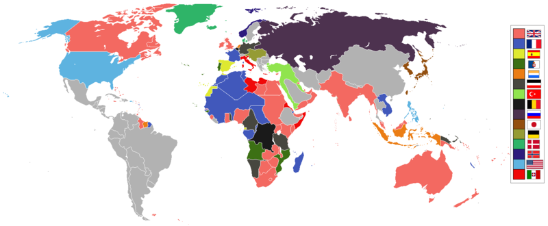
English: World empires and colonies in 1914, just before the First World War.
|
||||||||||||||||
| 日期 | |||||||||||||||||
| 来源 | 自己的作品 | ||||||||||||||||
| 作者 | Andrew0921 | ||||||||||||||||
.jpg)
._LOC_2001620596.jpg)
British Empire
France
Spain
Portugal
Netherlands
German Empire
Ottoman
Belgium
Russia
Japan
Denmark
Norway
United States of America
Italy
Independent/other countries
许可协议
我,本作品著作权人,特此采用以下许可协议发表本作品:
本文件采用知识共享署名 3.0 未本地化版本许可协议授权。
- 您可以自由地:
- 共享 – 复制、发行并传播本作品
- 修改 – 改编作品
- 惟须遵守下列条件:
- 署名 – 您必须对作品进行署名,提供授权条款的链接,并说明是否对原始内容进行了更改。您可以用任何合理的方式来署名,但不得以任何方式表明许可人认可您或您的使用。
文件历史
点击某个日期/时间查看对应时刻的文件。
| 日期/时间 | 缩略图 | 大小 | 用户 | 备注 | |
|---|---|---|---|---|---|
| 当前 | 2021年11月8日 (一) 09:28 | | 1,522 × 628(45 KB) | Randomastwritter | jubaland |
| 2021年4月14日 (三) 00:00 |  | 1,522 × 628(45 KB) | Offa29 | Fixed Togoland colour | |
| 2020年4月24日 (五) 18:57 |  | 1,522 × 628(45 KB) | The- | Norwegian flag | |
| 2020年4月24日 (五) 17:08 |  | 1,522 × 628(45 KB) | The- | If an old map with wrongly drawn borders is replaced with a better map wth a minor colour error, then fix that minor colour error. Don't just blithely revert to the bad old map. | |
| 2020年3月17日 (二) 21:52 |  | 1,474 × 620(36 KB) | Makkkkus | Replaced the Swedish-Norwegian union flag with the Norwegian flag. | |
| 2020年3月13日 (五) 19:25 |  | 1,474 × 620(22 KB) | Morris-frank | The new version introduced a big regression (coloring spain in the color of italy), also it did not contribute anything useful. | |
| 2019年8月14日 (三) 21:49 |  | 1,522 × 628(45 KB) | The- | More accurate map | |
| 2016年7月5日 (二) 12:47 |  | 1,474 × 620(22 KB) | Maproom | Removed borders between provinces of Australia, as requested at https://en.wikipedia.org/wiki/Wikipedia:Graphics_Lab/Map_workshop#FIFA_World_Cup_Maps_-_Colonial_Boundaries , because it had been united into a single dominion before 1914. | |
| 2010年12月26日 (日) 00:00 |  | 1,474 × 620(33 KB) | Quigley | by 1914, Qing Dynasty had collapsed and Republic of China established | |
| 2010年11月22日 (一) 13:56 |  | 1,474 × 620(20 KB) | AnonMoos | cropping margins, increasing PNG compression |
文件用途
以下页面使用本文件:
全域文件用途
以下其他wiki使用此文件:
- af.wikipedia.org上的用途
- ar.wikipedia.org上的用途
- azb.wikipedia.org上的用途
- bn.wikipedia.org上的用途
- ca.wikipedia.org上的用途
- da.wikipedia.org上的用途
- en.wikipedia.org上的用途
- eo.wikipedia.org上的用途
- eo.wikiquote.org上的用途
- es.wikipedia.org上的用途
- fa.wikipedia.org上的用途
- fi.wikipedia.org上的用途
- fr.wikipedia.org上的用途
- fy.wikipedia.org上的用途
- gl.wikipedia.org上的用途
- hu.wikipedia.org上的用途
- it.wikipedia.org上的用途
- ja.wikipedia.org上的用途
- jv.wikipedia.org上的用途
- ka.wikipedia.org上的用途
- lv.wikipedia.org上的用途
- mk.wikipedia.org上的用途
- ml.wikipedia.org上的用途
- oc.wikipedia.org上的用途
- pt.wikipedia.org上的用途
- ta.wikipedia.org上的用途
- te.wikipedia.org上的用途
查看本文件的更多全域用途。