File:Yuma arizona map.jpg

本预览的尺寸:406 × 599像素。 其他分辨率:162 × 240像素 | 576 × 850像素。
原始文件 (576 × 850像素,文件大小:57 KB,MIME类型:image/jpeg)
| 描述 |
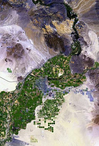
The raw satellite imagery shown in these images was obtained from NASA and/or the US Geological Survey. Post-processing and production by http://www.terraprints.com The en:Colorado River is the border between California, (top, and left), and Arizona, (bottom, and right). The en:Yuma Desert is shown quite prominently, south of Yuma, and the Fortuna Foothills, at the west of the en:Gila Mountains (Yuma County). The Yuma Desert is at the northwest of the Picacho Volcanic field complex, and the great: Gran Desierto de Altar, of north and northwest, Sonora state Mexico. (Note the en:Alluvial fans, especially around the Cargo Muchacho Mountains of California, but throughout the photo.) |
| 日期 | |
| 来源 | http://www.terraprints.com |
| 作者 | http://www.terraprints.com |
| 註解 | 該圖片含有註解:在維基媒體共享資源上查看註解 |
文件历史
点击某个日期/时间查看对应时刻的文件。
| 日期/时间 | 缩略图 | 大小 | 用户 | 备注 | |
|---|---|---|---|---|---|
| 当前 | 2007年9月25日 (二) 17:49 | | 576 × 850(57 KB) | Marku1988 | |
| 2006年10月25日 (三) 18:52 |  | 671 × 1,000(67 KB) | Terraprints | {{Information |Description=The raw satellite imagery shown in these images was obtain from NASA and/or the US Geological Survey. Post-processing and production by http://www.terraprints.com |Source=http://www.terraprints.com |Date=20061025 |Author=http:// |
文件用途
以下页面使用本文件:
全域文件用途
以下其他wiki使用此文件:
- arz.wikipedia.org上的用途
- ceb.wikipedia.org上的用途
- en.wikipedia.org上的用途
- es.wikipedia.org上的用途
- fr.wikipedia.org上的用途
- fy.wikipedia.org上的用途
- he.wikipedia.org上的用途
- ja.wikipedia.org上的用途
- lld.wikipedia.org上的用途
- nn.wikipedia.org上的用途
- www.wikidata.org上的用途