File:Campaign of the Battle of Ain Jalut 1260.svg

此SVG文件的PNG预览的大小:432 × 572像素。 其他分辨率:181 × 240像素 | 362 × 480像素 | 580 × 768像素 | 773 × 1,024像素 | 1,547 × 2,048像素。
原始文件 (SVG文件,尺寸为432 × 572像素,文件大小:146 KB)
摘要
| 描述 |
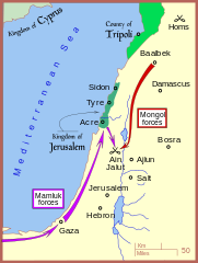
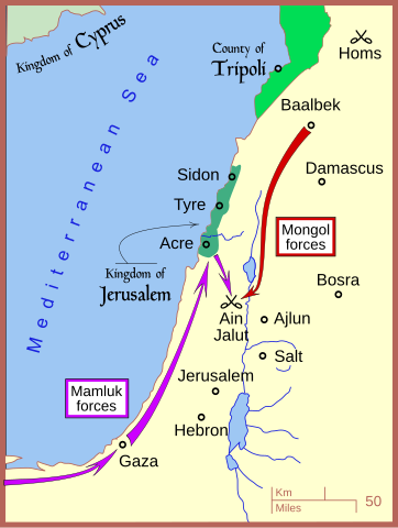
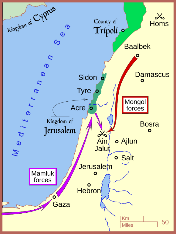
English: A map of the campaign leading to the Battle of Ain Jalut — in 1260 CE. |
| 日期 | |
| 来源 | 自己的作品 |
| 作者 | MapMaster |
| 其他版本 |
[]
|


|
This SVG file contains embedded text that can be translated into your language, using any capable SVG editor, text editor or the SVG Translate tool. For more information see: About translating SVG files. |
References
- Amitai-Preiss, Reuven (1995年) 《 Mongols and Mamluks: The Mamluk-Ilkhanid War, 1260-1281》、Cambridge University Press, Cambridge ISBN: 978-0521462266.
- Tschanz, David W. (July/August 2007). "History's Hinge: 'Ain Jalut". Saudi Aramco World. Retrieved on 2007-09-24.
The borders of the rump Kingdom of Jerusalem and the County of Tripoli are based on:
- Sheperd, William R. (1911) "Mediterranean Lands after 1204", in Historical Atlas, New York: Henry Holt and Company, p. 73.
许可协议
我,本作品著作权人,特此采用以下许可协议发表本作品:
本文件采用知识共享署名 3.0 未本地化版本许可协议授权。
- 您可以自由地:
- 共享 – 复制、发行并传播本作品
- 修改 – 改编作品
- 惟须遵守下列条件:
- 署名 – 您必须对作品进行署名,提供授权条款的链接,并说明是否对原始内容进行了更改。您可以用任何合理的方式来署名,但不得以任何方式表明许可人认可您或您的使用。
文件历史
点击某个日期/时间查看对应时刻的文件。
| 日期/时间 | 缩略图 | 大小 | 用户 | 备注 | |
|---|---|---|---|---|---|
| 当前 | 2008年7月7日 (一) 19:01 | | 432 × 572(146 KB) | MapMaster | adjusting colors |
| 2008年6月18日 (三) 04:53 |  | 432 × 572(151 KB) | MapMaster | ||
| 2008年6月13日 (五) 16:22 |  | 432 × 572(146 KB) | MapMaster | minor edits | |
| 2008年6月13日 (五) 11:33 |  | 434 × 574(126 KB) | MapMaster | {{Information |Description={{en|1=A map of the campaign leading to the Battle of Ain Jalut, 1260.}} |Source=Own work by uploader |Author=MapMaster |Date=13 June 2008 |Permission= |other_versions= }} {{ImageUpload|full}} |
文件用途
以下页面使用本文件:
全域文件用途
以下其他wiki使用此文件:
- azb.wikipedia.org上的用途
- ba.wikipedia.org上的用途
- bg.wikipedia.org上的用途
- bn.wikipedia.org上的用途
- ca.wikipedia.org上的用途
- ckb.wikipedia.org上的用途
- cs.wikipedia.org上的用途
- de.wikipedia.org上的用途
- en.wikipedia.org上的用途
- es.wikipedia.org上的用途
- et.wikipedia.org上的用途
- fr.wikipedia.org上的用途
- he.wikipedia.org上的用途
- hr.wikipedia.org上的用途
- id.wikipedia.org上的用途
- ja.wikipedia.org上的用途
- ko.wikipedia.org上的用途
- lt.wikipedia.org上的用途
- ml.wikipedia.org上的用途
- nl.wikipedia.org上的用途
- no.wikipedia.org上的用途
- pl.wikipedia.org上的用途
- pnb.wikipedia.org上的用途
- ru.wikipedia.org上的用途
- sl.wikipedia.org上的用途
- so.wikipedia.org上的用途
- sr.wikipedia.org上的用途
- su.wikipedia.org上的用途
- sv.wikipedia.org上的用途
- th.wikipedia.org上的用途
- tr.wikipedia.org上的用途
- ug.wikipedia.org上的用途
- uk.wikipedia.org上的用途
- ur.wikipedia.org上的用途
- uz.wikipedia.org上的用途
- www.wikidata.org上的用途