File:Serbia1878.png
本预览的尺寸:622 × 599像素。 其他分辨率:249 × 240像素 | 498 × 480像素 | 654 × 630像素。
原始文件 (654 × 630像素,文件大小:42 KB,MIME类型:image/png)

|
此historical map图片可使用矢量图形重新创建为SVG文件。这具有很多好处;更多信息请参见共享资源:待清理媒体。如果存在此图片的SVG格式,请将其上传,然后将此模板替换为
{{vector version available|新图片名称}}。
建议您将SVG命名为“Serbia1878.svg”,这样在使用Vector version available(或Vva)模板时就不需要填写新图片名称参数。 |
摘要
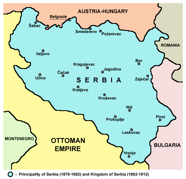
- English: Principality of Serbia (1878-1882) and Kingdom of Serbia (1882–1912).
- Srpskohrvatski / српскохрватски: Kneževina Srbija (1878-1882) i Kraljevina Srbija (1882-1912).
Source and licence
Self-made map by PANONIAN
| 本作品已被作者PANONIAN释出到公有领域。这适用于全世界。 在一些国家这可能不合法;如果是这样的话,那么: |

|
This map has been uploaded by Electionworld from en.wikipedia.org to enable the |
References
- The Times History of Europe, Times Books, London, 2002.
- Denis Šehić - Demir Šehić, Istorijski atlas Sveta, Beograd, 2007.
- Istorijski atlas, Geokarta, Beograd, 1999.
- Školski istorijski atlas, Zavod za izdavanje udžbenika SR Srbije, Beograd, 1970.
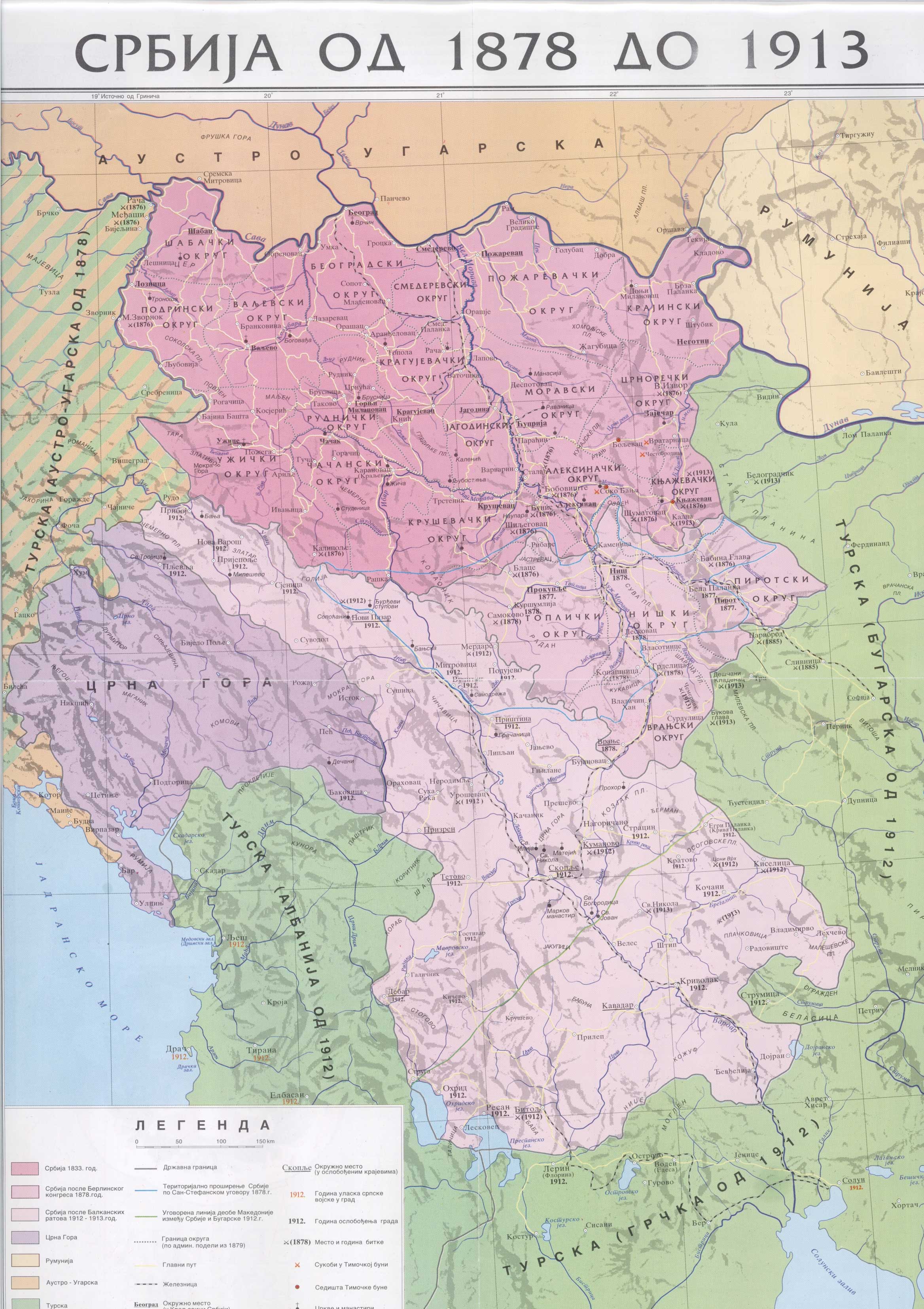
- http://anamnesis.info/resources/Srbija1878-1913.jpg
- http://terkepek.adatbank.transindex.ro/kepek/netre/99.gif
derivative works
Derivative works of this file: Kingdom of Serbia 1882–1912.png
文件历史
点击某个日期/时间查看对应时刻的文件。
| 日期/时间 | 缩略图 | 大小 | 用户 | 备注 | |
|---|---|---|---|---|---|
| 当前 | 2010年1月10日 (日) 17:52 | | 654 × 630(42 KB) | PANONIAN | improved version |
| 2006年12月21日 (四) 21:38 |  | 627 × 602(13 KB) | Electionworld | {{ew|en|PANONIAN}} Self-made map by PANONIAN {{PD-user|PANONIAN}} Category:Maps of Serbia |
文件用途
以下2个页面使用本文件:
全域文件用途
以下其他wiki使用此文件:
- ar.wikipedia.org上的用途
- azb.wikipedia.org上的用途
- az.wikipedia.org上的用途
- ba.wikipedia.org上的用途
- be-tarask.wikipedia.org上的用途
- be.wikipedia.org上的用途
- bg.wikipedia.org上的用途
- ca.wikipedia.org上的用途
- cs.wikipedia.org上的用途
- el.wikipedia.org上的用途
- en.wikipedia.org上的用途
- es.wikipedia.org上的用途
- et.wikipedia.org上的用途
- eu.wikipedia.org上的用途
- fa.wikipedia.org上的用途
- gl.wikipedia.org上的用途
- id.wikipedia.org上的用途
- it.wikipedia.org上的用途
- ja.wikipedia.org上的用途
- ms.wikipedia.org上的用途
- nl.wikipedia.org上的用途
- pl.wikipedia.org上的用途
- pnb.wikipedia.org上的用途
- pt.wikipedia.org上的用途
- ro.wikipedia.org上的用途
- ru.wikipedia.org上的用途
- sh.wikipedia.org上的用途
- sk.wikipedia.org上的用途
- sl.wikipedia.org上的用途
- sq.wikipedia.org上的用途
- sr.wikipedia.org上的用途
- sv.wikipedia.org上的用途
查看本文件的更多全域用途。