File:Aerial view of Porirua City Centre and Porirua Station.jpg

本预览的尺寸:800 × 534像素。 其他分辨率:320 × 214像素 | 640 × 427像素 | 1,024 × 683像素 | 1,280 × 854像素 | 2,560 × 1,709像素 | 5,145 × 3,434像素。
原始文件 (5,145 × 3,434像素,文件大小:7.05 MB,MIME类型:image/jpeg)
摘要
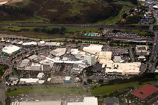
| 描述 | Viewed from west, with considerable visible detail at 100%. In upper right with the crowded parking lot is Porirua Station. North City Shopping Centre is on right (tan colored building with Kmart and Farmer's logo). State Highway 1 (SH 1N) and railway are at top. Green-walled building on left is a Countdown supermarket. |
| 日期 | |
| 来源 | Aerial view of Porirua City Centre and Porirua Station |
| 作者 | Derrick Coetzee (User:Dcoetzee) |
| 相机位置 | | 在以下服务上查看本图像和附近其他图像: OpenStreetMap |
|---|
许可协议
| 本作品采用知识共享CC0 1.0 通用公有领域贡献许可协议授权。 | |
| 采用本宣告发表本作品的人,已在法律允许的范围内,通过在全世界放弃其对本作品拥有的著作权法规定的所有权利(包括所有相关权利),将本作品贡献至公有领域。您可以复制、修改、传播和表演本作品,将其用于商业目的,无需要求授权。
|
| This image, originally posted to Flickr, was reviewed on 14 September 2013 by the administrator or reviewer Dcoetzee, who confirmed that it was available on Flickr under the stated license on that date. |
文件历史
点击某个日期/时间查看对应时刻的文件。
| 日期/时间 | 缩略图 | 大小 | 用户 | 备注 | |
|---|---|---|---|---|---|
| 当前 | 2013年9月14日 (六) 05:33 | | 5,145 × 3,434(7.05 MB) | Dcoetzee | Transferred from Flickr by User:Dcoetzee using flickr2commons |
文件用途
全域文件用途
以下其他wiki使用此文件:
- ar.wikipedia.org上的用途
- arz.wikipedia.org上的用途
- avk.wikipedia.org上的用途
- ca.wikipedia.org上的用途
- de.wikivoyage.org上的用途
- en.wikipedia.org上的用途
- en.wikivoyage.org上的用途
- es.wikipedia.org上的用途
- hi.wikipedia.org上的用途
- it.wikipedia.org上的用途
- ja.wikipedia.org上的用途
- ka.wikipedia.org上的用途
- ko.wikipedia.org上的用途
- no.wikipedia.org上的用途
- pl.wikipedia.org上的用途
- ru.wikipedia.org上的用途
- simple.wikipedia.org上的用途
- tr.wikipedia.org上的用途
- uk.wikipedia.org上的用途
- vo.wikipedia.org上的用途
- www.wikidata.org上的用途
- zh-yue.wikipedia.org上的用途