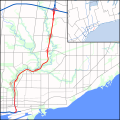
File:DVP map.svg

此SVG文件的PNG预览的大小:600 × 600像素。 其他分辨率:240 × 240像素 | 480 × 480像素 | 768 × 768像素 | 1,024 × 1,024像素 | 2,048 × 2,048像素 | 1,420 × 1,420像素。
原始文件 (SVG文件,尺寸为1,420 × 1,420像素,文件大小:545 KB)
文件历史
点击某个日期/时间查看对应时刻的文件。
| 日期/时间 | 缩略图 | 大小 | 用户 | 备注 | |
|---|---|---|---|---|---|
| 当前 | 2010年8月23日 (一) 02:13 |  | 1,420 × 1,420(545 KB) | Floydian | Complete rest of route, expand scope to the east to add a context map of GTA. Add rivers and parkland. |
| 2010年7月24日 (六) 05:44 |  | 840 × 1,420(305 KB) | Floydian | Adjust colours, add rails, some interchanges | |
| 2010年7月20日 (二) 18:51 |  | 840 × 1,420(29 KB) | Floydian | Fix issues | |
| 2010年7月20日 (二) 18:34 |  | 1,700 × 2,800(31 KB) | Floydian | {{Information |Description=A map of the Don Valley Parkway in Toronto, Canada, showing the freeways and arterial roads in the vicinity of it and Lake Ontario. First draft (no interchanges or urban/green landuse) |Source={{own}} based on the map on page 3 |
文件用途
以下页面使用本文件:
全域文件用途
以下其他wiki使用此文件:
- en.wikipedia.org上的用途
- fa.wikipedia.org上的用途
- fr.wikipedia.org上的用途
- kn.wikipedia.org上的用途
- www.wikidata.org上的用途
