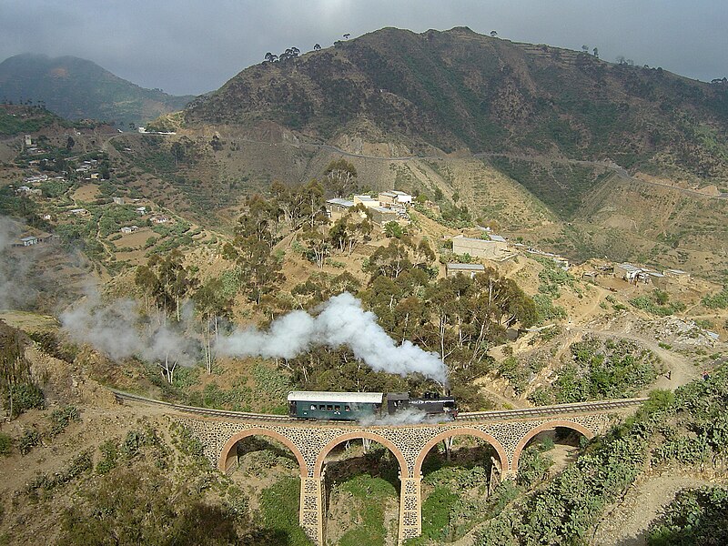
File:Eritrean Railway - 2008-11-04-edit1.jpg

本预览的尺寸:800 × 600像素。 其他分辨率:320 × 240像素 | 640 × 480像素 | 1,024 × 768像素 | 1,280 × 960像素 | 2,400 × 1,800像素。
原始文件 (2,400 × 1,800像素,文件大小:1.86 MB,MIME类型:image/jpeg)
文件历史
点击某个日期/时间查看对应时刻的文件。
| 日期/时间 | 缩略图 | 大小 | 用户 | 备注 | |
|---|---|---|---|---|---|
| 当前 | 2009年11月8日 (日) 18:55 |  | 2,400 × 1,800(1.86 MB) | Voice of Clam | As this version is a Featured Image on enwiki, I do not think it is appropriate to replace it without discussion. I will upload the new version with a different name. |
| 2009年11月8日 (日) 05:42 |  | 2,400 × 1,800(1.87 MB) | Citypeek | white balance | |
| 2008年11月14日 (五) 12:38 |  | 2,400 × 1,800(1.86 MB) | Jjron | {{User:Tivedshambo/Information |Description={{w|Eritrean Railway}}, showing mountainous terrain traversed between Arbaroba and {{w|Asmara}}. <br>This is an edited version of Image:Eritrean Railway - Tivedshambo 2008-11-04.jpg by jjron |
文件用途
以下页面使用本文件:
全域文件用途
以下其他wiki使用此文件:
- bg.wikipedia.org上的用途
- bs.wikipedia.org上的用途
- cy.wikipedia.org上的用途
- de.wikipedia.org上的用途
- en.wikipedia.org上的用途
- Eritrean Railway
- 1911 in rail transport
- Portal:Africa/Featured picture
- Wikipedia:Featured pictures thumbs/14
- Wikipedia:Picture peer review/Archives/Oct-Dec 2008
- Wikipedia:Picture peer review/Eritrean Railway
- Wikipedia:Featured picture candidates/Eritrean Railway
- Wikipedia:Wikipedia Signpost/2009-01-03/Features and admins
- Wikipedia:Featured picture candidates/December-2008
- Portal:Africa/Featured picture/29
- Wikipedia:Picture of the day/September 2009
- Template:POTD/2009-09-15
- User talk:Sarah777/Archive 25
- Portal:Eritrea/Featured picture
- Portal:Eritrea/Featured article
- Portal:Eritrea
- Portal:Eritrea/Featured picture/8
- Wikipedia:Featured pictures/Vehicles/Land
- Wikipedia:Wikipedia Signpost/2010-09-20/WikiProject report
- User talk:Voice of Clam/Archives/2008
- User talk:Voice of Clam/Archives/2009
- List of companies based in Eritrea
- Portal:Trains/Selected article/2014 archive
- Portal:Trains/Selected article/Week 34, 2014
- Wikipedia:Wikipedia Signpost/2009-01-03/SPV
- Wikipedia:Wikipedia Signpost/Single/2010-09-20
- User talk:Voice of Clam/Archives
- Portal:Trains/Did you know/December 2016
- User:Alb2017/sandbox
- Italian colonial railways
- Portal:Eritrea/Featured article/7
- User:Moonraker/P
- Wikipedia:Wikipedia Signpost/Single/2009-01-03
- eo.wikipedia.org上的用途
- es.wikipedia.org上的用途
- fa.wikipedia.org上的用途
- fr.wikipedia.org上的用途
- ha.wikipedia.org上的用途
查看此文件的更多全域用途。


