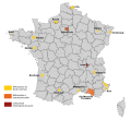
File:Métropoles en France.svg

此SVG文件的PNG预览的大小:760 × 600像素。 其他分辨率:304 × 240像素 | 608 × 480像素 | 973 × 768像素 | 1,280 × 1,010像素 | 2,560 × 2,021像素 | 840 × 663像素。
原始文件 (SVG文件,尺寸为840 × 663像素,文件大小:3.05 MB)
文件历史
点击某个日期/时间查看对应时刻的文件。
| 日期/时间 | 缩略图 | 大小 | 用户 | 备注 | |
|---|---|---|---|---|---|
| 当前 | 2018年2月24日 (六) 13:49 |  | 840 × 663(3.05 MB) | Touam | Avec http://professionnels.ign.fr/adminexpress, février 2018. Les limites des départements restent visibles "sous" les métropoles. |
| 2018年1月31日 (三) 19:56 |  | 886 × 708(3.38 MB) | Touam | Grand Dijon -> Dijon. | |
| 2018年1月28日 (日) 20:41 |  | 1,013 × 687(3.38 MB) | Touam | Carte des métropoles françaises, à partir de [https://www.data.gouv.fr/fr/datasets/admin-express/ ADMIN EXPRESS] - juin 2017, l'aide de [https://fr.wikipedia.org/wiki/Wikip%C3%A9dia:Atelier_graphique/Cartes Wikipédia:Atelier graphique/Cartes], QGIS... | |
| 2017年5月7日 (日) 08:15 |  | 1,100 × 1,000(7.43 MB) | Superbenjamin | Orléans | |
| 2017年5月2日 (二) 11:28 |  | 1,100 × 1,000(7.42 MB) | Superbenjamin | Création de la métropole de Dijon. | |
| 2017年3月22日 (三) 21:36 |  | 1,100 × 1,000(7.4 MB) | Superbenjamin | Création de la métropole de Tours. | |
| 2017年1月3日 (二) 14:19 |  | 1,100 × 1,000(7.39 MB) | Superbenjamin | Agrandissement de la métropole de Strasbourg | |
| 2016年4月22日 (五) 11:44 |  | 1,100 × 1,000(7.34 MB) | Superbenjamin | Mise à jour : Nancy | |
| 2016年3月7日 (一) 11:03 |  | 1,100 × 1,000(7.11 MB) | Superbenjamin | Carte à jour avec poids réduit | |
| 2016年2月28日 (日) 20:08 |  | 1,100 × 1,000(9.04 MB) | Gelli1742 | Reverted to version as of 19:12, 1 July 2014 (UTC) |
文件用途
以下页面使用本文件:
全域文件用途
以下其他wiki使用此文件:
- als.wikipedia.org上的用途
- ca.wikipedia.org上的用途
- cs.wikipedia.org上的用途
- en.wikipedia.org上的用途
- es.wikipedia.org上的用途
- fr.wikipedia.org上的用途
- hu.wikipedia.org上的用途
- ja.wikipedia.org上的用途
