File:Map Europe alliances 1914-en.svg

此SVG文件的PNG预览的大小:800 × 473像素。 其他分辨率:320 × 189像素 | 640 × 379像素 | 1,024 × 606像素 | 1,280 × 758像素 | 2,560 × 1,515像素 | 1,002 × 593像素。
原始文件 (SVG文件,尺寸为1,002 × 593像素,文件大小:97 KB)
| 描述 |
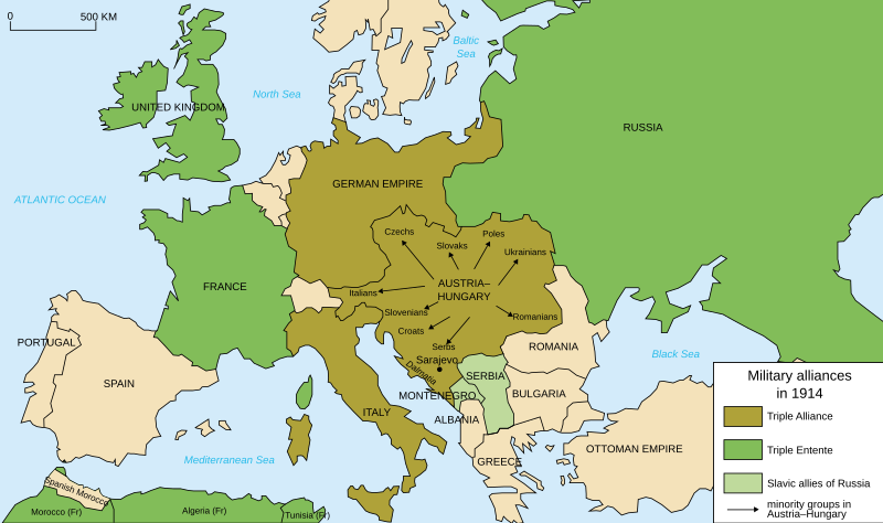
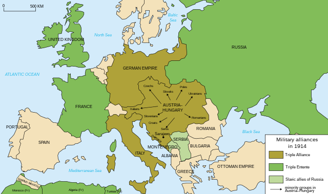
Deutsch: Karte von Militärbündnisse in Europa in 1914, (Englisch) English: Map of military alliances of Europe in 1914. (English) Français : Carte des alliances militaires en Europe en 1914. (Anglais) Русский: Схема военных альянсов в Европе в 1914 г. (англ.) |
| 日期 |
|
| 来源 | Translated in English from French SVG Map_Europe_alliances_1914-fr.svg |
| 作者 |
|
| 其他版本 |
此文件衍生的作品: Map Europe alliances 1914-he.svg
[] .gif)
|


W3C-validity not checked.

|
This SVG file contains embedded text that can be translated into your language, using any capable SVG editor, text editor or the SVG Translate tool. For more information see: About translating SVG files. |
| 这是一张修改过的图片,这意味着它已在原版本的基础上通过软件进行了编辑,改动内容:English translation。其原始版本为:Map Europe alliances 1914-fr.svg。修改者:Fluteflute。
|
我,本作品著作权人,特此采用以下许可协议发表本作品:
- 您可以自由地:
- 共享 – 复制、发行并传播本作品
- 修改 – 改编作品
- 惟须遵守下列条件:
- 署名 – 您必须对作品进行署名,提供授权条款的链接,并说明是否对原始内容进行了更改。您可以用任何合理的方式来署名,但不得以任何方式表明许可人认可您或您的使用。
- 相同方式共享 – 如果您再混合、转换或者基于本作品进行创作,您必须以与原先许可协议相同或相兼容的许可协议分发您贡献的作品。
原始上传日志
This image is a derivative work of the following images:
- File:Map_Europe_alliances_1914-fr.svg licensed with Cc-by-sa-2.5,2.0,1.0, Cc-by-sa-2.5,2.0,1.0/en
- 2007-02-26T23:36:35Z Bibi Saint-Pol 998x593 (100171 Bytes) {{Information |Description= {{fr|Carte des alliances militaires en Europe en 1914.}} |Source=Création personnelle(version renommée de [[:Image:Les rivalités en Europe en 1914.svg]]) |Date=2006-10-31 |Author=[[User:Histori
Uploaded with derivativeFX
文件历史
点击某个日期/时间查看对应时刻的文件。
| 日期/时间 | 缩略图 | 大小 | 用户 | 备注 | |
|---|---|---|---|---|---|
| 当前 | 2021年4月4日 (日) 20:59 | | 1,002 × 593(97 KB) | Andrewtips | File uploaded using svgtranslate tool (https://svgtranslate.toolforge.org/). Added translation for zh-hant. |
| 2020年8月4日 (二) 21:02 |  | 1,002 × 593(92 KB) | Ionaki | File uploaded using svgtranslate tool (https://svgtranslate.toolforge.org/). Added translation for eu. | |
| 2020年8月4日 (二) 21:02 |  | 1,002 × 593(92 KB) | Ionaki | File uploaded using svgtranslate tool (https://svgtranslate.toolforge.org/). Added translation for eu. | |
| 2020年8月4日 (二) 20:59 |  | 1,002 × 593(92 KB) | Ionaki | File uploaded using svgtranslate tool (https://svgtranslate.toolforge.org/). Added translation for eu. | |
| 2020年8月2日 (日) 15:14 |  | 1,002 × 593(72 KB) | Bogomolov.PL | reservoirs on Dnieper, Don and Volga rivers were built after Second WW, erased. Romania, Serbia, Montenegro, Albania and Bulgaria borders corrected | |
| 2017年1月21日 (六) 11:22 |  | 1,002 × 593(75 KB) | Perey | This portrays the Triple Alliance, not the Central Powers (of which Italy was never one). Error introduced in version dated 2010-03-07 by Mnmazur (talk). | |
| 2015年11月28日 (六) 21:18 |  | 1,002 × 593(75 KB) | Turnless | Aland Islands | |
| 2015年1月2日 (五) 12:25 |  | 1,002 × 593(75 KB) | Borodun | Moonsund archipelago is territory of Russia | |
| 2015年1月2日 (五) 00:30 |  | 1,002 × 593(70 KB) | ZYjacklin | Capitalize the name for Romania. | |
| 2010年11月17日 (三) 16:49 |  | 1,002 × 593(70 KB) | Ras67 | "cropped" and minor things |
文件用途
以下页面使用本文件:
全域文件用途
以下其他wiki使用此文件:
- ar.wikipedia.org上的用途
- bcl.wikipedia.org上的用途
- bh.wikipedia.org上的用途
- br.wikipedia.org上的用途
- cy.wikipedia.org上的用途
- da.wikipedia.org上的用途
- el.wikipedia.org上的用途
- en.wikipedia.org上的用途
- Franz Joseph I of Austria
- Triple Alliance (1882)
- Military alliance
- Triple Entente
- Yugoslav Committee
- Treaty of London (1915)
- Switzerland during the World Wars
- Polish Legions in World War I
- Two-front war
- History of Western civilization
- World War I
- France–Russia relations
- 1914
- European balance of power
- Wikipedia:Graphics Lab/Illustration workshop/Archive/Nov 2010
- Sweden during World War I
- Talk:World War I/Archive 16
- User:Chickstarr404/Gather lists/16060 – "Paris 1919" by Margaret Macmillan
- User:Chickstarr404/Gather lists
- User:Falcaorib
- Friedrich von Pourtalès
- Draft:Participants of World War I
- en.wikibooks.org上的用途
- en.wiktionary.org上的用途
- et.wikipedia.org上的用途
- eu.wikipedia.org上的用途
- fa.wikipedia.org上的用途
- fiu-vro.wikipedia.org上的用途
- fi.wikipedia.org上的用途
- fi.wikibooks.org上的用途
- fo.wikipedia.org上的用途
- fy.wikipedia.org上的用途
查看本文件的更多全域用途。