File:Rif Dimashq offensive (March 2013).svg

此SVG文件的PNG预览的大小:800 × 523像素。 其他分辨率:320 × 209像素 | 640 × 419像素 | 1,024 × 670像素 | 1,280 × 837像素 | 2,560 × 1,674像素 | 1,856 × 1,214像素。
原始文件 (SVG文件,尺寸为1,856 × 1,214像素,文件大小:13.07 MB)
.svg?uselang=zh-hans)
.svg?uselang=zh-hans)
.svg?action=history&uselang=zh-hans)
.svg)
摘要
| 描述 |
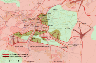
English: Map of the March 2013 Rif Dimashq offensive, showing frontlines before the offensive, and the current strategic situation.
العربية: خريطة تظهر هجوم مارس 2013 على دمشق، تظهر الخريطة خطوط الجبهات قبل الهجوم، و الوضع الاستراتيجي منذ سبتمبر 2013. |
| 日期 | |
| 来源 | 自己的作品, OpenStreetMap |
| 作者 | MrPenguin20 |
许可协议
| This work contains information from OpenStreetMap, which is made available under the Open Database License (ODbL).
The ODbL does not require any particular license for maps produced from ODbL data. Prior to 1 August 2020, map tiles produced by the OpenStreetMap Foundation were licensed under the CC-BY-SA-2.0 license. Maps produced by other people may be subject to other licences. |
我,本作品著作权人,特此采用以下许可协议发表本作品:
本文件采用知识共享署名-相同方式共享 3.0 未本地化版本许可协议授权。
- 您可以自由地:
- 共享 – 复制、发行并传播本作品
- 修改 – 改编作品
- 惟须遵守下列条件:
- 署名 – 您必须对作品进行署名,提供授权条款的链接,并说明是否对原始内容进行了更改。您可以用任何合理的方式来署名,但不得以任何方式表明许可人认可您或您的使用。
- 相同方式共享 – 如果您再混合、转换或者基于本作品进行创作,您必须以与原先许可协议相同或相兼容的许可协议分发您贡献的作品。
文件历史
点击某个日期/时间查看对应时刻的文件。
.svg&variant=zh-hans&dir=prev)
.svg&variant=zh-hans&offset=20130903001601)
.svg&variant=zh-hans&offset=&limit=20)
.svg&variant=zh-hans&offset=&limit=50)
.svg&variant=zh-hans&offset=&limit=100)
.svg&variant=zh-hans&offset=&limit=250)
.svg&variant=zh-hans&offset=&limit=500)
| 日期/时间 | 缩略图 | 大小 | 用户 | 备注 | |
|---|---|---|---|---|---|
| 当前 | 2018年8月6日 (一) 17:27 | | 1,856 × 1,214(13.07 MB) | Rr016 | Filled in empty spaces, as per AlAboud83's request |
| 2013年12月7日 (六) 16:55 |  | 1,856 × 1,214(13.06 MB) | EkoGraf | This map is for the offensive that lasted until late August. A map for the development of the offensive that started in September already exists | |
| 2013年11月13日 (三) 19:04 |  | 1,485 × 971(11.56 MB) | U5K0 | hejeira to loyalists per enwp | |
| 2013年11月7日 (四) 21:57 |  | 1,485 × 971(11.56 MB) | U5K0 | Al-Sabinah to loyalists per enwp article | |
| 2013年10月26日 (六) 09:57 |  | 1,485 × 971(11.56 MB) | U5K0 | Hatetat al-Turkman per english wp article | |
| 2013年10月9日 (三) 17:37 |  | 1,485 × 971(10.4 MB) | Ahmadac~commonswiki | Updated map based on https://en.wikipedia.org/wiki/Template:Syrian_civil_war_detailed_map - Also added Husseiniyah under SAA control. http://www.al-akhbar.com/node/192916 | |
| 2013年9月23日 (一) 00:12 |  | 1,856 × 1,214(13.06 MB) | MrPenguin20 | Uploaded correct version. | |
| 2013年9月23日 (一) 00:06 |  | 1,856 × 1,214(13.06 MB) | MrPenguin20 | Marked several military bases. Marked Sheba'a. Daraya contested. | |
| 2013年9月15日 (日) 13:34 |  | 1,856 × 1,214(9.33 MB) | MrPenguin20 | The M5 highway under the control of SAA before the attack. M1 also under government control. Al-Sabinah, Hujayrah, Deir Salman, Yalda, Babbila and Beit sahem are contested. Hatitat al-Turkuman and Deir al-Asafir under attack from SAA. Qadam also cont... | |
| 2013年9月3日 (二) 00:16 |  | 1,856 × 1,214(9.36 MB) | MrPenguin20 | Jamraya & surrounding area under government control according to [https://www.facebook.com/photo.php?fbid=575156802521211&set=a.224155897621305.50803.217139528322942&type=1 new map]. |
文件用途
以下页面使用本文件:
全域文件用途
以下其他wiki使用此文件:
- ar.wikipedia.org上的用途
- bg.wikipedia.org上的用途
- en.wikipedia.org上的用途
- es.wikipedia.org上的用途
- fr.wikipedia.org上的用途
- he.wikipedia.org上的用途
- it.wikipedia.org上的用途
- pl.wikipedia.org上的用途
- ru.wikipedia.org上的用途
- tr.wikipedia.org上的用途
- www.wikidata.org上的用途
.svg)