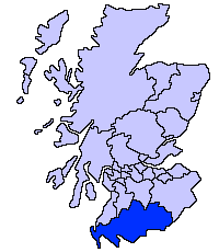
File:ScotlandDumfriesGalloway.png
ScotlandDumfriesGalloway.png (200 × 230像素,文件大小:4 KB,MIME类型:image/png)
文件历史
点击某个日期/时间查看对应时刻的文件。
| 日期/时间 | 缩略图 | 大小 | 用户 | 备注 | |
|---|---|---|---|---|---|
| 当前 | 2005年5月17日 (二) 21:31 |  | 200 × 230(4 KB) | Voyager | Dumfries and Galloway unitary council Slightly edited version of a map drawn by Morwen {{GFDL}} Category:Maps of Scottish unitary councils |
文件用途
以下页面使用本文件:
全域文件用途
以下其他wiki使用此文件:
- ast.wikipedia.org上的用途
- be.wikipedia.org上的用途
- bg.wikipedia.org上的用途
- ca.wikipedia.org上的用途
- cy.wikipedia.org上的用途
- de.wikipedia.org上的用途
- de.wikivoyage.org上的用途
- en.wikipedia.org上的用途
- eu.wikipedia.org上的用途
- Dumfries eta Galloway
- Dumfries
- Lankide:Euskaldunaa
- Stranraer
- Annan
- Txantiloi:Dumfries eta Galloway
- Wikiproiektu:Irlanda, Gales eta Eskoziako udalerriak
- Applegarthtown
- Inch (Dumfries eta Galloway)
- Bladnoch (Wigtownshire)
- Cairnryan
- Glasserton
- Glenluce
- Kirkcolm
- Kirkmaiden
- Leswalt
- Mochrum
- New Luce
- Newton Stewart
- Old Luce
- Penninghame
- Port William (Dumfries eta Galloway)
- Portpatrick
- Sandhead
- Sorbie
- Stoneykirk
- Wigtown
- Whithorn
- Kirkcowan
- Kirkinner
- Anwoth
- Caerlaverock
- Barburgh Mill
- Brow (Dumfries eta Galloway)
查看此文件的更多全域用途。


