File:Tamis banat1718 1739.png

本预览的尺寸:465 × 599像素。 其他分辨率:186 × 240像素 | 373 × 480像素 | 1,008 × 1,298像素。
原始文件 (1,008 × 1,298像素,文件大小:146 KB,MIME类型:image/png)
摘要
| 描述 |
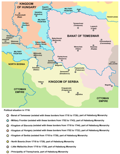
English: Map of the Banat of Temeswar, Kingdom of Serbia and Military Frontier in 1718. Serbian: Мапа Тамишког Баната, Краљевине Србије и војне границе 1718. године. |
| 日期 | |
| 来源 | 自己的作品 |
| 作者 | PANONIAN |
许可协议
| 我,本作品著作权人,释出本作品至公有领域。这适用于全世界。 在一些国家这可能不合法;如果是这样的话,那么: 我无条件地授予任何人以任何目的使用本作品的权利,除非这些条件是法律规定所必需的。 |
References
- The Times History of Europe, Times Books, London, 2002.
- Istorijski atlas, Zavod za udžbenike i nastavna sredstva - Zavod za kartografiju "Geokarta", Beograd, 1999.
- Školski istorijski atlas, Zavod za izdavanje udžbenika Socijalističke Republike Srbije, Beograd, 1970.
- Denis Šehić - Demir Šehić, Istorijski atlas Sveta, Beograd, 2007.
- Milan Tutorov, Banatska rapsodija - istorika Zrenjanina i Banata, Novi Sad, 2001.
- Peter Rokai - Zoltan Đere - Tibor Pal - Aleksandar Kasaš, Istorija Mađara, Beograd, 2002.
- Dr Dušan J. Popović, Srbi u Vojvodini, knjiga 2, Novi Sad, 1990.
- Dr Milenko Palić, Srbi u Mađarskoj - Ugarskoj do 1918, Novi Sad, 1995.
- J. H. Šviker, Politička istorija Srba u Ugarskoj, Novi Sad - Beograd, 1998.
- Fridrih Vilhelm fon Taube, Istorijski i geografski opis Kraljevine Slavonije i Vojvodstva Srema, Novi Sad, 1998.
- Miodrag Milin, Vekovima zajedno (Iz istorije srpsko-rumunskih odnosa), Temišvar, 1995.
- Suzana Milovanović, Potiska i pomoriška vojna granica (1702-1751), Novi Sad, 2003.
- Dimitrije Boarov, Politička istorija Vojvodine, Novi Sad, 2001.
- Drago Njegovan, Prisajedinjenje Vojvodine Srbiji, Novi Sad, 2004.
- Olga Zirojević, Srbija pod turskom vlašću 1459-1804, Beograd, 2007.
- Vladimir Ćorović, Ilustrovana istorija Srba, knjiga četvrta, Beograd, 2006.
- http://www.conflicts.rem33.com/images/Ungarn/OESTEREICH%20ENTWICKLUNG.jpg
- http://terkepek.adatbank.transindex.ro/kepek/netre/51.gif
- http://upload.wikimedia.org/wikipedia/commons/8/8e/Growth_of_Habsburg_territories.jpg
- http://images.nationmaster.com/images/motw/historical/ward_1912/south_east_europe_1648.jpg archive copy at the Wayback Machine
- http://dic.academic.ru/pictures/dewiki/80/Passarowitz_1718.JPG
- http://upload.wikimedia.org/wikipedia/commons/7/7c/Temeswarer_Banat.JPG
- http://gettysburg.cdmhost.com/cdm4/item_viewer.php?CISOROOT=/p4016coll7&CISOPTR=429&CISOBOX=1&REC=2
- http://www.garwood-voigt.com/catalogues/H22365SclavoniaeHomann.jpg
文件历史
点击某个日期/时间查看对应时刻的文件。
| 日期/时间 | 缩略图 | 大小 | 用户 | 备注 | |
|---|---|---|---|---|---|
| 当前 | 2014年6月23日 (一) 22:47 | | 1,008 × 1,298(146 KB) | PANONIAN | aesthetics |
| 2014年6月23日 (一) 11:07 |  | 1,008 × 1,298(146 KB) | PANONIAN | aesthetics | |
| 2013年9月12日 (四) 09:12 |  | 1,008 × 1,298(149 KB) | PANONIAN | correction | |
| 2013年2月13日 (三) 18:34 |  | 1,008 × 1,298(149 KB) | PANONIAN | correction | |
| 2012年12月22日 (六) 13:15 |  | 1,008 × 1,298(149 KB) | PANONIAN | minor aesthetical improvement | |
| 2011年9月30日 (五) 17:07 |  | 998 × 1,294(149 KB) | PANONIAN | correction | |
| 2011年9月29日 (四) 15:47 |  | 998 × 1,294(149 KB) | PANONIAN | correction | |
| 2011年9月29日 (四) 14:07 |  | 998 × 1,294(149 KB) | PANONIAN | some corrections and improvements | |
| 2009年12月21日 (一) 19:52 |  | 998 × 1,206(144 KB) | PANONIAN | {{Information |Description={{en|1=Map of the Banat of Temeswar and Military Frontier in 1718}} |Source={{own}} |Author=PANONIAN |Date= |Permission= |other_versions= }} |
文件用途
以下页面使用本文件:
全域文件用途
以下其他wiki使用此文件:
- ar.wikipedia.org上的用途
- az.wikipedia.org上的用途
- be-tarask.wikipedia.org上的用途
- be.wikipedia.org上的用途
- bg.wikipedia.org上的用途
- bs.wikipedia.org上的用途
- ca.wikipedia.org上的用途
- cs.wikipedia.org上的用途
- da.wikipedia.org上的用途
- de.wikipedia.org上的用途
- el.wikipedia.org上的用途
- en.wikipedia.org上的用途
- es.wikipedia.org上的用途
- eu.wikipedia.org上的用途
- fa.wikipedia.org上的用途
- fr.wikipedia.org上的用途
- gl.wikipedia.org上的用途
- he.wikipedia.org上的用途
- hr.wikipedia.org上的用途
- it.wikipedia.org上的用途
- ko.wikipedia.org上的用途
- mk.wikipedia.org上的用途
- mr.wikipedia.org上的用途
- nl.wikipedia.org上的用途
查看本文件的更多全域用途。