File:Beeching2.svg

此 SVG 檔案的 PNG 預覽的大小:364 × 599 像素。 其他解析度:146 × 240 像素 | 291 × 480 像素 | 466 × 768 像素 | 622 × 1,024 像素 | 1,244 × 2,048 像素 | 1,480 × 2,436 像素。
原始檔案 (SVG 檔案,表面大小:1,480 × 2,436 像素,檔案大小:182 KB)
摘要
| 描述 |
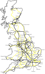
This is what the BR network could have looked like, by the 1980s, had the Beeching II developments gone ahead. All lines except those shown in bold would have been closed. Swathes of the country — notably North, South West Scotland and most of Wales — would no longer have lines. The plans were quietly shelved and closures slowed. Beeching resigned. Notes:
|
| 日期 | |
| 來源 | self-made, based on an a poster from Beeching II report |
| 作者 | Was done on behalf of the Wikipedia User:Btline (original image up-loader) by Cronholm144 via the Wikipedia Graphic Lab |
| 其他版本 | File:Beeching2_clear.svg |
授權條款
I, Cronholm144,此作品的版權所有人,決定用以下授權條款發佈本作品:

|
已授權您依據自由軟體基金會發行的無固定段落、封面文字和封底文字GNU自由文件授權條款1.2版或任意後續版本,對本檔進行複製、傳播和/或修改。該協議的副本列在GNU自由文件授權條款中。 |
| 此檔案採用創用CC 姓名標示-相同方式分享 3.0 未在地化版本授權條款。 | ||
| 姓名標示: I, Cronholm144 | ||
| ||
| 已新增授權條款標題至此檔案,作為GFDL授權更新的一部份。 |
您可以選擇您需要的授權條款。
檔案歷史
點選日期/時間以檢視該時間的檔案版本。
| 日期/時間 | 縮圖 | 尺寸 | 使用者 | 備註 | |
|---|---|---|---|---|---|
| 目前 | 2007年7月13日 (五) 12:24 | | 1,480 × 2,436(182 KB) | Time3000~commonswiki | Fix island obscuring text |
| 2007年7月13日 (五) 12:21 |  | 1,480 × 2,436(182 KB) | Time3000~commonswiki | Include islands (e.g. Isle of Mann) and fix typo | |
| 2007年7月10日 (二) 20:50 |  | 1,444 × 2,436(198 KB) | Cronholm144 | tweak | |
| 2007年7月10日 (二) 01:22 |  | 1,444 × 2,436(198 KB) | Cronholm144 | cities | |
| 2007年7月9日 (一) 02:09 |  | 1,284 × 2,436(114 KB) | Cronholm144 | {{Information |Description=map o' Britain |Source=self-made |Date= |Author= Cronholm144 }} |
檔案用途
下列頁面有用到此檔案:
全域檔案使用狀況
以下其他 wiki 使用了這個檔案:
- azb.wikipedia.org 的使用狀況
- cs.wikipedia.org 的使用狀況
- de.wikipedia.org 的使用狀況
- en.wikipedia.org 的使用狀況
- es.wikipedia.org 的使用狀況
- fr.wikipedia.org 的使用狀況
- hu.wikipedia.org 的使用狀況
- it.wikipedia.org 的使用狀況
- ja.wikipedia.org 的使用狀況
- lv.wikipedia.org 的使用狀況
- pt.wikipedia.org 的使用狀況
- ru.wikipedia.org 的使用狀況
- ur.wikipedia.org 的使用狀況