File:Circuit de Nevers Magny-Cours.svg

此 SVG 檔案的 PNG 預覽的大小:800 × 554 像素。 其他解析度:320 × 222 像素 | 640 × 443 像素 | 1,024 × 709 像素 | 1,280 × 886 像素 | 2,560 × 1,773 像素 | 1,356 × 939 像素。
原始檔案 (SVG 檔案,表面大小:1,356 × 939 像素,檔案大小:91 KB)
摘要
| 描述 |
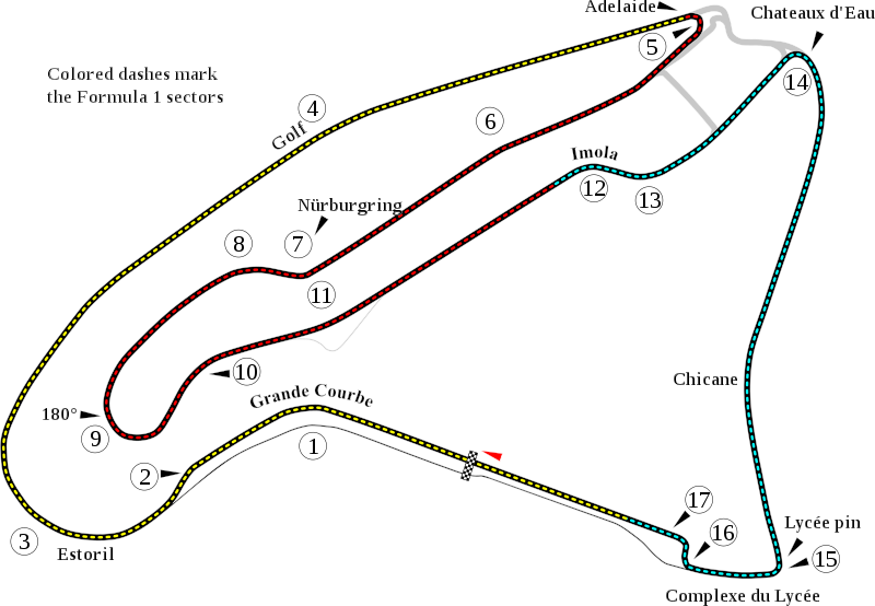
English: Track map of w:Circuit de Nevers Magny-Cours. |
| 日期 | |
| 來源 | 自己的作品 |
| 作者 | Will Pittenger |
| 其他版本 |
|

| 拍攝地點 | | 位於此地的本圖片與其他圖片: OpenStreetMap |
|---|
授權條款
| 我,此作品的版權所有人,釋出此作品至公共領域。此授權條款在全世界均適用。 這可能在某些國家不合法,如果是的話: 我授予任何人有權利使用此作品於任何用途,除受法律約束外,不受任何限制。 |
檔案歷史
點選日期/時間以檢視該時間的檔案版本。
| 日期/時間 | 縮圖 | 尺寸 | 使用者 | 備註 | |
|---|---|---|---|---|---|
| 目前 | 2008年7月13日 (日) 05:09 | | 1,356 × 939(91 KB) | Will Pittenger | New version gets around the text on path bug in Mediawiki by turning such text into objects. To edit the text, please use the previous version. |
| 2008年7月13日 (日) 05:06 |  | 1,356 × 939(67 KB) | Will Pittenger | {{Information |Description={{en|1=Track map of w:Circuit de Nevers Magny-Cours.}} |Source=Own work by uploader |Author=Will Pittenger |Date=7-13-2008 |Permission= |other_versions=<gallery>Image:Circuit de Nevers Magny-Cours.png |
檔案用途
下列9個頁面有用到此檔案:
全域檔案使用狀況
以下其他 wiki 使用了這個檔案:
- af.wikipedia.org 的使用狀況
- ar.wikipedia.org 的使用狀況
- ast.wikipedia.org 的使用狀況
- bg.wikipedia.org 的使用狀況
- bn.wikipedia.org 的使用狀況
- br.wikipedia.org 的使用狀況
- ca.wikipedia.org 的使用狀況
- cs.wikipedia.org 的使用狀況
- de.wikipedia.org 的使用狀況
檢視此檔案的更多全域使用狀況。