File:CraterHighlands Tanzania NASA.jpg
預覽大小:484 × 600 像素。 其他解析度:194 × 240 像素 | 540 × 669 像素。
原始檔案 (540 × 669 像素,檔案大小:118 KB,MIME 類型:image/jpeg)
摘要
| 描述 |
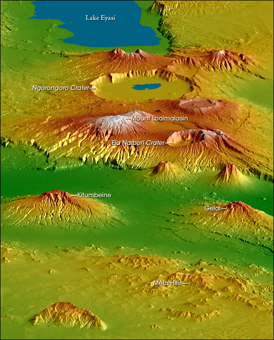
English: Topographical map of the w:Crater Highlands in Tanzania. Color indicates height, with lowest elevations in green and highest elevations in white. Shading shows the slope. The vertical relief has been exaggerated by a factor of 2 to reveal greater detail about the landscape. The image is oriented as though you were looking from the north toward the southwest.
Afrikaans: Topografiese kaart van Tanzanië se kraterhooglande. Kleur dui hoogte aan, met laagste gebiede in groen en hoogste hoogtes in wit. Skadu dui hellings aan, en die vertikale reliëf is verdubbel om meer landskapdetail weer te gee. Die uitsig is georiënteer van die noordooste na suidweste. Natronmeer is net buite sig aan regterhand. |
| 日期 | |
| 來源 | https://earthobservatory.nasa.gov/IOTD/view.php?id=6316 |
| 作者 | Robert E. Crippen, NASA/JPL Shuttle Radar Topography Mission team. Labels by NASA Earth Observatory newsroom. |
| 授權許可 (重用此檔案) |
US government, public domain. |
| 其他版本 | Larger, unannotated version available at source URL. |
授權條款
| 本作品由NASA創作,屬於公有領域。根據NASA的版權政策:“NASA的創作除非另有聲明否則不受版權保護。”(參見:Template:PD-USGov/zh,NASA版權政策或JPL圖像使用政策) | ||
 |
警告:
|
檔案歷史
點選日期/時間以檢視該時間的檔案版本。
| 日期/時間 | 縮圖 | 尺寸 | 使用者 | 備註 | |
|---|---|---|---|---|---|
| 目前 | 2006年4月28日 (五) 17:53 | | 540 × 669(118 KB) | Holly Cheng | {{Information | Description=Topographical map of the w:Crater Highlands in Tanzania. Color indicates height, with lowest elevations in green and highest elevations in white. Shading shows the slope. The vertical relief has been exaggerated by a factor |
檔案用途
全域檔案使用狀況
以下其他 wiki 使用了這個檔案:
- arz.wikipedia.org 的使用狀況
- avk.wikipedia.org 的使用狀況
- ceb.wikipedia.org 的使用狀況
- de.wikipedia.org 的使用狀況
- el.wikipedia.org 的使用狀況
- en.wikipedia.org 的使用狀況
- es.wikipedia.org 的使用狀況
- fr.wikipedia.org 的使用狀況
- he.wikipedia.org 的使用狀況
- hr.wikipedia.org 的使用狀況
- ru.wikipedia.org 的使用狀況
- sh.wikipedia.org 的使用狀況
- sl.wikipedia.org 的使用狀況
- sr.wikipedia.org 的使用狀況
- sw.wikipedia.org 的使用狀況
- uk.wikipedia.org 的使用狀況
- www.wikidata.org 的使用狀況