File:Detailed map of Benson, Arizona.png
無更高解析度可提供。
Detailed_map_of_Benson,_Arizona.png (575 × 425 像素,檔案大小:24 KB,MIME 類型:image/png)

|
本圖片是以PNG、GIF或JPEG格式上傳。然而,其中包含的資料或訊息,應該重新建立成可縮放向量圖形(SVG)檔案,以更有效率或更準確的方式儲存。如有可能,請上傳本圖片的SVG格式版本。在上傳之後,請修改維基各姊妹計畫中所有使用舊版圖片的條目(列在圖像連結章節中),替換為新版圖片,並在舊圖片的描述頁中加入{{Vector version available|新圖片名稱.svg}}模板,同時移除本模板。
|
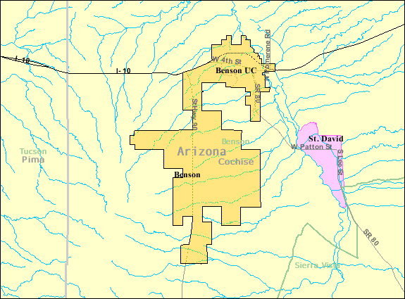
| 描述 | Map of Benson, a city in Cochise County, Arizona, United States, with its boundaries at the time of the 2000 census. | |||
| 日期 | 日期不明; downloaded by me on 13 December 2008 | |||
| 來源 | http://factfinder.census.gov/leg2/46/120825446.gif, from http://factfinder.census.gov | |||
| 作者 | United States Census Bureau | |||
| 授權許可 (重用此檔案) |
|

檔案歷史
點選日期/時間以檢視該時間的檔案版本。
| 日期/時間 | 縮圖 | 尺寸 | 使用者 | 備註 | |
|---|---|---|---|---|---|
| 目前 | 2008年12月14日 (日) 01:57 | | 575 × 425(24 KB) | Nyttend | {{Information |Description=Map of {{w|Benson, Arizona|Benson}}, a city in {{w|Cochise County, Arizona|Cochise County}}, {{w|Arizona}}, {{w|United States}}, with its boundaries at the time of the {{w|2000 United States Census|2000 census}}. |Source=http:// |
檔案用途
下列頁面有用到此檔案:
全域檔案使用狀況
以下其他 wiki 使用了這個檔案:
- ar.wikipedia.org 的使用狀況
- arz.wikipedia.org 的使用狀況
- azb.wikipedia.org 的使用狀況
- ca.wikipedia.org 的使用狀況
- ceb.wikipedia.org 的使用狀況
- en.wikipedia.org 的使用狀況
- eu.wikipedia.org 的使用狀況
- fa.wikipedia.org 的使用狀況
- fr.wikipedia.org 的使用狀況
- sr.wikipedia.org 的使用狀況
- sv.wikipedia.org 的使用狀況
- tt.wikipedia.org 的使用狀況
- ur.wikipedia.org 的使用狀況
- www.wikidata.org 的使用狀況
- zh-min-nan.wikipedia.org 的使用狀況